Paulding, Michigan
| Paulding, Michigan | |
|---|---|
| Unincorporated community | |
|
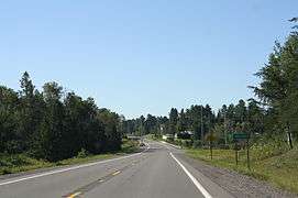
Downtown Paulding | |
 Paulding, Michigan | |
| Coordinates: 46°24′05″N 89°10′48″W / 46.40139°N 89.18000°WCoordinates: 46°24′05″N 89°10′48″W / 46.40139°N 89.18000°W[1] | |
| Country | United States |
| State | Michigan |
| County | Ontonagon |
| Township | Haight |
| Elevation[1] | 1,358 ft (414 m) |
| Time zone | Eastern (EST) (UTC-5) |
| • Summer (DST) | EDT (UTC-4) |
| Area code(s) | 906 |
| GNIS feature ID | 1621164[1] |

Paulding is an unincorporated community in Ontonagon County, Michigan, United States. Paulding is located in Haight Township along US Highway 45, 13.5 miles (21.7 km) southeast of Ontonagon.[2] The Paulding Light, part of the area's folklore, is visible in a valley near Paulding.
History
A post office called Paulding was established in 1893, and remained in operation until it was discontinued in 1971.[3] The community was named for John Paulding, a militiaman in the American Revolution.[4]
Paulding sign
References
- 1 2 3 U.S. Geological Survey Geographic Names Information System: Paulding, Michigan
- ↑ Ontonagon County (pdf) (Map). Michigan Department of Technology, Management and Budget. 2010. Retrieved 7 May 2011.
- ↑ "Ontonagon County". Jim Forte Postal History. Retrieved 24 March 2015.
- ↑ Chicago and North Western Railway Company (1908). A History of the Origin of the Place Names Connected with the Chicago & North Western and Chicago, St. Paul, Minneapolis & Omaha Railways. p. 112.
Municipalities and communities of Ontonagon County, Michigan, United States | ||
|---|---|---|
| Village | 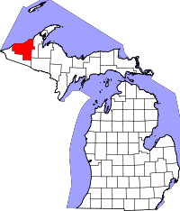 | |
| Townships | ||
| CDP | ||
| Other unincorporated communities | ||
| Ghost towns | ||
This article is issued from Wikipedia - version of the 10/23/2016. The text is available under the Creative Commons Attribution/Share Alike but additional terms may apply for the media files.