Bruce Crossing, Michigan
| Bruce Crossing, Michigan | |
|---|---|
| Unincorporated community | |
|
Downtown Bruce Crossing | |
 Bruce Crossing, Michigan | |
| Coordinates: 46°32′06″N 89°10′44″W / 46.53500°N 89.17889°WCoordinates: 46°32′06″N 89°10′44″W / 46.53500°N 89.17889°W[1] | |
| Country | United States |
| State | Michigan |
| County | Ontonagon |
| Township | Stannard |
| Elevation[1] | 1,138 ft (347 m) |
| Population [1] | ~5 |
| Time zone | Eastern (EST) (UTC-5) |
| • Summer (DST) | EDT (UTC-4) |
| ZIP code | 49912 |
| Area code(s) | 906 |
| GNIS feature ID | 622123[1] |

Bruce Crossing is an unincorporated community in Ontonagon County, Michigan, United States. Bruce Crossing is located in Stannard Township at the junction of US Highway 45 and M-28, 24.5 miles (39.4 km) south-southeast of Ontonagon.[2] Bruce Crossing has a post office with ZIP code 49912.[3]
History
Bruce Crossing was first settled by August Neuman, who built a sawmill at the location. The community was originally named Bruce's Crossing when its post office opened on March 5, 1888. The name came from the first postmaster, Donald M. Bruce, who owned a store at the crossing of the Duluth, South Shore and Atlantic Railway and the old Military Road. It was shortened to Bruce Crossing on August 13, 1891.[4]
Images
-

Bruce Crossing post office
-

Bruce Crossing sign on US 45
References
- 1 2 3 4 U.S. Geological Survey Geographic Names Information System: Bruce Crossing, Michigan
- ↑ Ontonagon County (pdf) (Map). Michigan Department of Technology, Management and Budget. 2010. Retrieved May 9, 2011.
- ↑ ZIP Code Lookup, United States Post Office
- ↑ Romig, Walter (1986) [1973]. Michigan Place Names. Detroit, Michigan: Wayne State University Press. ISBN 0-8143-1838-X.
Municipalities and communities of Ontonagon County, Michigan, United States | ||
|---|---|---|
| Village | 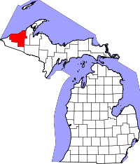 | |
| Townships | ||
| CDP | ||
| Other unincorporated communities | ||
| Ghost towns | ||