Page, Oklahoma
| Page, Oklahoma | |
|---|---|
| Unincorporated community | |
 Page, Oklahoma | |
| Coordinates: 34°42′38″N 94°32′59″W / 34.71056°N 94.54972°WCoordinates: 34°42′38″N 94°32′59″W / 34.71056°N 94.54972°W | |
| Country | United States |
| State | Oklahoma |
| County | Le Flore |
| Elevation | 922 ft (281 m) |
| Time zone | Central (CST) (UTC-6) |
| • Summer (DST) | CDT (UTC-5) |
| Area code(s) | 539/918 |
| GNIS feature ID | 1100715[1] |
Page is an unincorporated community in Le Flore County, Oklahoma, United States. Page is located along U.S. Route 59 and U.S. Route 270 5.5 miles (8.9 km) west of the Arkansas border.
History
Page was named for William C. Page, a Choctaw Indian.[2]
References
- ↑ "US Board on Geographic Names". United States Geological Survey. 2007-10-25. Retrieved 2008-01-31.
- ↑ Heavener Historical Society (2013). Heavener (LeFlore County) Oklahoma. Xlibris Corporation. p. 281.
Municipalities and communities of Le Flore County, Oklahoma, United States | ||
|---|---|---|
| Cities | 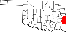 | |
| Towns | ||
| CDP | ||
| Other unincorporated communities | ||
| Footnotes | ‡This populated place also has portions in an adjacent county or counties | |
This article is issued from Wikipedia - version of the 11/3/2016. The text is available under the Creative Commons Attribution/Share Alike but additional terms may apply for the media files.