Padroni, Colorado
| Padroni, Colorado | |
|---|---|
| CDP | |
 Location in Logan County and the state of Colorado | |
| Coordinates: 40°46′45″N 103°10′21″W / 40.77917°N 103.17250°WCoordinates: 40°46′45″N 103°10′21″W / 40.77917°N 103.17250°W | |
| Country |
|
| State |
|
| County | Logan[1] |
| Area | |
| • Total | 0.8 sq mi (2.1 km2) |
| • Land | 0.8 sq mi (2.1 km2) |
| • Water | 0 sq mi (0 km2) |
| Elevation[1] | 3,999 ft (1,219 m) |
| Population (2000) | |
| • Total | 97 |
| • Density | 121.3/sq mi (46.2/km2) |
| Time zone | Mountain (MST) (UTC-7) |
| • Summer (DST) | MDT (UTC-6) |
| ZIP code[2] | 80745 |
| Area code(s) | 970 |
| FIPS code | 08-56695 |
| GNIS feature ID | 0171130 |
Padroni is a census-designated place (CDP) in Logan County, Colorado, United States. The population was 97 at the 2000 census.[3] The Padroni Post Office has the ZIP Code 80745.[2]
Padroni was named for George and Tom Padroni, early settlers.[4]
Geography
Padroni is located at 40°46′45″N 103°10′21″W / 40.77917°N 103.17250°W (40.779175, -103.172394).[5]
According to the United States Census Bureau, the CDP has a total area of 0.8 square miles (2.1 km2), all of it land.
Demographics
As of the census[3] of 2000, there were 97 people, 37 households, and 27 families residing in the CDP. The population density was 121.0 people per square mile (46.8/km²). There were 43 housing units at an average density of 53.6 per square mile (20.8/km²). The racial makeup of the CDP was 86.60% White, 1.03% Pacific Islander, 10.31% from other races, and 2.06% from two or more races. Hispanic or Latino of any race were 11.34% of the population.
There were 37 households out of which 37.8% had children under the age of 18 living with them, 43.2% were married couples living together, 10.8% had a female householder with no husband present, and 27.0% were non-families. 24.3% of all households were made up of individuals and 8.1% had someone living alone who was 65 years of age or older. The average household size was 2.62 and the average family size was 2.96.
In the CDP the population was spread out with 33.0% under the age of 18, 10.3% from 18 to 24, 27.8% from 25 to 44, 20.6% from 45 to 64, and 8.2% who were 65 years of age or older. The median age was 29 years. For every 100 females there were 120.5 males. For every 100 females age 18 and over, there were 103.1 males.
The median income for a household in the CDP was $28,750, and the median income for a family was $39,167. Males had a median income of $36,875 versus $0 for females. The per capita income for the CDP was $10,608. There were 31.8% of families and 16.9% of the population living below the poverty line, including 27.3% of under eighteens and none of those over 64.
See also
References
- 1 2 "US Board on Geographic Names". United States Geological Survey. 2007-10-25. Retrieved 2008-01-31.
- 1 2 "ZIP Code Lookup" (JavaScript/HTML). United States Postal Service. December 14, 2006. Retrieved December 14, 2006.
- 1 2 "American FactFinder". United States Census Bureau. Retrieved 2008-01-31.
- ↑ Dawson, John Frank. Place names in Colorado: why 700 communities were so named, 150 of Spanish or Indian origin. Denver, CO: The J. Frank Dawson Publishing Co. p. 39.
- ↑ "US Gazetteer files: 2010, 2000, and 1990". United States Census Bureau. 2011-02-12. Retrieved 2011-04-23.
Municipalities and communities of Logan County, Colorado, United States | ||
|---|---|---|
| City | 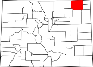 | |
| Towns | ||
| CDPs | ||
| Unincorporated communities | ||