Outer Drive
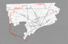 Outer Drive highlighted in red | |
| Length | 40 mi (60 km) |
|---|---|
| South end | Jefferson Avenue in Ecorse |
| Major junctions |
|
| Eastern end | Mack Avenue – border of Detroit and Grosse Pointe Park |
Outer Drive is a bypass road which encircles both the eastern and western portions of the Metro Detroit area. It resembles a jagged horseshoe and was not originally intended to move traffic as much as to provide a pleasurable drive around Detroit. A boulevard for the vast majority of its length, Outer Drive includes travel through beautiful subdivisions, school sites, and park areas. First proposed in 1918, it immediately won acceptance and eventually evolved into the thoroughfare which exists today. A 1929 article in Michigan Women magazine, predicted a "...great pleasure boulevard..." that would be "...like a necklace around Detroit...." However, in an article dated August 4, 2004, in the Metro Times, Michigan author Curt Guyette described Outer Drive as "...one of the oddest city thoroughfares in the country." Outer Drive was once made famous by the elm trees that lined it, but in a circa-1983 WXYZ-TV report about the road, reporter Erik Smith mentioned that "...now, it may be more famous for it's [sic] potholes."
While mostly within the Detroit city limits, Outer Drive also ventures into the cities of Allen Park, Dearborn, Dearborn Heights, Ecorse, Lincoln Park, and Melvindale.
At its western starting point at Jefferson Avenue in Ecorse near the Detroit River, the thoroughfare meanders northwesterly to Michigan Avenue, where it makes a northeast bend along the River Rouge; it then continues northeasterly with several 90 degree angle turns until Outer Drive ends at Livernois Avenue. Outer Drive then resumes on Detroit's east side, over-taking State Fair Avenue, Conner Avenue, Alter Road, Chandler Park Drive, and Whittier Avenue, with its eastern terminus at Mack Avenue at the northern edge of the City of Grosse Pointe Park, but not actually entering that city. Outer Drive is notable for having several isolated divided portions. There are three such segments. The largest is the westernmost section, beginning at Jefferson Avenue in Ecorse and ending at Livernois Avenue in Detroit—this particular sector is 23.6 miles (38.0 km).[1] The middle section is between Dequindre Road (at East State Fair Avenue) and at East McNichols Road (between the Mount Olivet Cemetery and the Coleman A. Young International Airport); that section is 4.9 miles (7.9 km) entirely within Detroit.[2] The easternmost section is between Conner Avenue (near Gratiot Avenue) and Mack Avenue; this portion, too is 5.3 miles (8.5 km), completely inside Detroit.[3]
Unlike other divided highways in Michigan, Outer Drive allows standard left turns on and off of it. The speed limit on Outer Drive is at most 35 mph (56 km/h); it is low since other main urban streets have a speed limit of 45 mph (72 km/h).
See also
References
Metro Times Article about the history of Outer Drive