Osen
| Osen kommune | |||
|---|---|---|---|
| Municipality | |||
 | |||
| |||
 Osen within Sør-Trøndelag | |||
| Coordinates: 64°17′52″N 10°30′48″E / 64.29778°N 10.51333°ECoordinates: 64°17′52″N 10°30′48″E / 64.29778°N 10.51333°E | |||
| Country | Norway | ||
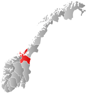
| County | Sør-Trøndelag | ||
| District | Fosen | ||
| Administrative centre | Steinsdalen | ||
| Government | |||
| • Mayor (2007) | Jørn Nordmeland (formerly of SV) | ||
| Area | |||
| • Total | 387.48 km2 (149.61 sq mi) | ||
| • Land | 369.99 km2 (142.85 sq mi) | ||
| • Water | 17.49 km2 (6.75 sq mi) | ||
| Area rank | 241 in Norway | ||
| Population (2010) | |||
| • Total | 1,033 | ||
| • Rank | 405 in Norway | ||
| • Density | 2.8/km2 (7/sq mi) | ||
| • Change (10 years) | -13.5 % | ||
| Demonym(s) | Osing[1] | ||
| Time zone | CET (UTC+1) | ||
| • Summer (DST) | CEST (UTC+2) | ||
| ISO 3166 code | NO-1633 | ||
| Official language form | Bokmål | ||
| Website |
www | ||
|
| |||

![]() Osen is a municipality in Sør-Trøndelag county, Norway. It is part of the Fosen region. The administrative centre of the municipality is the village of Steinsdalen. Osen is one of two Norwegian municipalities that do not have any non-western immigrants as of 1 January 2008.[2]
Osen is a municipality in Sør-Trøndelag county, Norway. It is part of the Fosen region. The administrative centre of the municipality is the village of Steinsdalen. Osen is one of two Norwegian municipalities that do not have any non-western immigrants as of 1 January 2008.[2]
General information

The municipality of Osen was established on 1 June 1892 when the old municipality of Bjørnør was split into three municipalities. The initial population of Osen was 1,575. The municipal boundaries have not changed since.[3]
Name
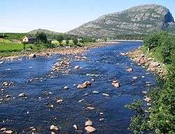
The municipality (originally the parish) is named after the old Osen farm (Old Norse: Óss), since the first church was built there. The name is identical with the word óss which means "mouth of a river" (here Steinselva). Osen ("the Os") is a later finite form of óss.[4]
History
Osen was used as a satellite prison camp during the World War Two, mainly for Yugoslavian population.
Coat-of-arms
The coat-of-arms is from modern times. They were granted on 27 March 1987, and is a copy of an old petroglyph. The arms show a part of a fishing net placed over the shield. The arms simply indicate the importance of fishing for the community. Several different arms were designed, all with fisheries as the main theme, but the council finally chose this one, which is unique among civic heraldry.[5]
Churches
The Church of Norway has one parish (sokn) within the municipality of Osen. It is part of the Deanery (prosti) of Fosen and the Diocese of Nidaros.
| Parish (Sokn) | Church Name | Year Built | Location of the Church |
|---|---|---|---|
| Osen | Osen kirke | 1877 | Steinsdalen |
| Seter kapell | 1969 | Seter |
Geography

The municipality of Osen is located to the north of Roan. The rest of the municipality is surrounded by Nord-Trøndelag county to the north and east. The ocean lies to the west.
Most of the residents live in the Steinsdalen valley or along the coast. The northern part of the municipality has no direct road connection to the rest of the municipality, but is connected to the municipality of Flatanger to the north.
The Kya lighthouse and Buholmråsa lighthouse lie in the ocean in the western part of the municipality.
References
- ↑ "Navn på steder og personer: Innbyggjarnamn" (in Norwegian). Språkrådet. Retrieved 2015-12-01.
- ↑ "Tabell 10 Innvandrerbefolkningen, etter vestlig og ikke-vestlig landbakgrunn og kommune" (in Norwegian). Statistics Norway. 1 January 2008.
- ↑ Jukvam, Dag (1999). "Historisk oversikt over endringer i kommune- og fylkesinndelingen" (PDF) (in Norwegian). Statistisk sentralbyrå.
- ↑ Rygh, Oluf (1901). Norske gaardnavne: Søndre Trondhjems amt (in Norwegian) (14 ed.). Kristiania, Norge: W. C. Fabritius & sønners bogtrikkeri. p. 3.
- ↑ Norske Kommunevåpen (1990). "Nye kommunevåbener i Norden". Retrieved 27 October 2008.
See also
External links
 Media related to Osen at Wikimedia Commons
 Sør-Trøndelag travel guide from Wikivoyage
- Municipal fact sheet from Statistics Norway