Flatanger
| Flatanger kommune | |||
|---|---|---|---|
| Municipality | |||
 | |||
| |||
 Flatanger within Nord-Trøndelag | |||
| Coordinates: 64°25′11″N 10°54′28″E / 64.41972°N 10.90778°ECoordinates: 64°25′11″N 10°54′28″E / 64.41972°N 10.90778°E | |||
| Country | Norway | ||
| County | Nord-Trøndelag | ||
| District | Namdalen | ||
| Administrative centre | Lauvsnes | ||
| Government | |||
| • Mayor (2003) | Reidar Lindseth (V) | ||
| Area | |||
| • Total | 459.30 km2 (177.34 sq mi) | ||
| • Land | 434.17 km2 (167.63 sq mi) | ||
| • Water | 25.13 km2 (9.70 sq mi) | ||
| Area rank | 219 in Norway | ||
| Population (2011) | |||
| • Total | 1,109 | ||
| • Rank | 390 in Norway | ||
| • Density | 2.6/km2 (7/sq mi) | ||
| • Change (10 years) | -4.2 % | ||
| Demonym(s) | Flatangring[1] | ||
| Time zone | CET (UTC+1) | ||
| • Summer (DST) | CEST (UTC+2) | ||
| ISO 3166 code | NO-1749 | ||
| Official language form | Neutral | ||
| Website |
www | ||
|
| |||

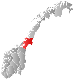
Flatanger is a municipality in Nord-Trøndelag county, Norway. It is part of the Namdalen region. The administrative centre of the municipality is the village of Lauvsnes. Other villages include Jøssund and Vik.
General information
Flatanger was established as a municipality on 1 January 1871 when it was separated from the large municipality of Fosnes. Initially, Flatanger had 1,472 residents. It is one of the few municipalities in Norway whose boundaries have not changed since it was established.[2]
Name
The municipality is named after the old name for one of the fjords in the area, but it is not known which one. The name is composed of two parts: flat, which probably means "shallow water", and angr, which means "fjord or inlet".[3][4]
Coat-of-arms
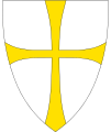
The coat-of-arms is from modern times; they were granted in 1990. The arms show three silver chevrons on a green background. The design was chosen to represent the bow of a boat, seen from the front.
Churches
The Church of Norway has one parish (sokn) within the municipality of Flatanger. It is part of the Namdal deanery in the Diocese of Nidaros.
| Parish (Sokn) | Church Name | Location of the Church | Year Built |
|---|---|---|---|
| Flatanger | Vik Church | Vik | 1873 |
| Løvøy Church | Lauvøya | 1871 |
Geography

The municipality consists mostly of mainland, but also includes almost 1,400 islands of various sizes. Some of the major islands include Bjørøya, Lauvøya, Villa, Halmøya, and Kvernøya. Ellingråsa Lighthouse is located on the island of Bjørøya and Villa Lighthouse is on Villa. These islands all lie on the south side of the Folda firth. The Namsenfjorden forms part of the northern boundary of the municipality.
Government
All municipalities in Norway, including Flatanger, are responsible for primary education (through 10th grade), outpatient health services, senior citizen services, unemployment and other social services, zoning, economic development, and municipal roads. The municipality is governed by a municipal council of elected representatives, which in turn elect a mayor.
Municipal council
The municipal council (Kommunestyre) of Flatanger is made up of 15 representatives that are elected to every four years. Currently, the party breakdown is as follows:[5]
| Party Name | Name in Norwegian | Number of representatives | |
|---|---|---|---|
| Labour Party | Arbeiderpartiet | 3 | |
| Progress Party | Fremskrittspartiet | 2 | |
| Conservative Party | Høyre | 2 | |
| Centre Party | Senterpartiet | 4 | |
| Socialist Left Party | Sosialistisk Venstreparti | 2 | |
| Liberal Party | Venstre | 2 | |
| Total number of members: | 15 | ||
Politics
In the 2007 municipal elections, Flatanger had the highest vote for the Venstre party in all of Norway, at 42.9 per cent.
Rock Climbing
Flatanger is also home to one of the world's hardest rock climbs. Change 9b+/5.15c+ which was first sent by Adam Ondra on the 4th of October 2012.
Famous people from Flatanger
- Brede Moe, footballer
- Adolf Ribsskog, school man and mayor
- Ole Konrad Ribsskog, school man and mayor
- Toralf Sandø, theater director and actor
- Julie Dahle Aagård, singer
References
- ↑ "Navn på steder og personer: Innbyggjarnamn" (in Norwegian). Språkrådet. Retrieved 2015-12-01.
- ↑ Jukvam, Dag (1999). "Historisk oversikt over endringer i kommune- og fylkesinndelingen" (PDF) (in Norwegian). Statistisk sentralbyrå.
- ↑ Store norske leksikon. "Flatanger" (in Norwegian). Retrieved 2011-08-18.
- ↑ Rygh, Oluf (1903). Norske gaardnavne: Nordre Trondhjems amt (dokpro.uio.no) (in Norwegian) (15 ed.). Kristiania, Norge: W. C. Fabritius & sønners bogtrikkeri. p. 344.
- ↑ "Table: 04813: Members of the local councils, by party/electoral list at the Municipal Council election (M)" (in Norwegian). Statistics Norway. 2015.
External links
| Wikimedia Commons has media related to Flatanger. |
 Nord-Trøndelag travel guide from Wikivoyage
- Municipal fact sheet from Statistics Norway