Orwood, Mississippi
| Orwood, Mississippi | |
|---|---|
| Ghost town | |
 Orwood, Mississippi | |
| Coordinates: 34°15′32″N 89°43′05″W / 34.25889°N 89.71806°WCoordinates: 34°15′32″N 89°43′05″W / 34.25889°N 89.71806°W | |
| Country | United States |
| State | Mississippi |
| County | Lafayette |
| Elevation | 397 ft (121 m) |
| Time zone | Central (CST) (UTC-6) |
| • Summer (DST) | CDT (UTC-5) |
| GNIS feature ID | 684410[1] |
Orwood is a ghost town in far southwestern Lafayette County, Mississippi. It was originally spelled “Orrwood,” but at some point the second “r” was dropped.
"The town was first settled by Green McKie who settled a farm in 1837. Later Charles H. Gray of Mecklenburg County, North Carolina moved to Orwood in 1839. Charles Gray was a wealthy planter who lost his fortune during the civil war. He has a beautiful old Southern Colonial home built by William Turner in 1854. According to the 1936 WPA records it was of the same design as the John Culley home in Oxford. Gray’s son, Dr. Ed Gray was living in the community during the yellow fever epidemic of 1876. The Entire Gray family fell ill with yellow fever and Dr. Gray died. His widow lived on in the family house for many years. Other early planters in Orwood were Nathaniel Dobson Gray, Ira Addison Orr, Josiah Robertson, Robert Nickle, John Henderson, Cyrus Wilson, Tom Robinson, and N. Brasel."
Church
"Some of the earliest settlers are buried in Water Valley where they attended church. The first person buried in Orwood was Joseph Capps in 1854. An infant of the McKie family was buried there in 1855. The Sand Spring Presbyterian Church is one of the most important parts of the history of this Community. In 1848 the territory was in the Chickasaw Presbytery of the Synod of Memphis. In September 1850, sixteen members of the Water Valley church, living on the North side of Yocona River, petitioned the Session of Water Valley church for permission to be organized into a separate church. That petition was granted and the first pastor, Rev. Angus Johnson and Ruling Elder John M. Phifer was appointed to organize the church on the first Sunday in October of 1850. Before that date, six more names were added to the list so the church was organized with 22 Charter members, as follows: Robert Nickle, Jane Nickle, N.D. Gray, Jane Gray, Mary E. Spears, Jane Spears, Katura Brazell, John W. Henderson, James M. Wilson, Drusilla Weir, Marcus McCord, Hannah McCord, Jane Robinson, Harriet Robinson, Clarissa Robinson, Josiah A. Robinson, John K. Robinson, A.W. Byers, Eliza Byers, C.H. Gray, Mrs. Sarah Gray, and Mary E. Orr."
"The first church building was made of logs and was located about a mile west of the present Church in Panola County. It was a Union building and was used by Methodists, Baptist, and Presbyterian. The present building was erected in 1854. Col. James Brown, of Oxford, donated the grounds, consisting of 17 ¾ acres. Another Oxford citizen, Mr. William Turner, was the contractor. The foundation timbers were hewn and hauled by slaves from several plantations. They also helped in the construction. The first Manse was built by Rev. R. W. Mecklin in 1879. This home was later known as the old Spears home. A second Manse was built in 1890."
School

Orwood had a successful school at one time. The early school was located behind the present Sand Spring Church. Another building was erected about 1910. It was described by O.D. Smith in 1937 as a frame building costing $300.00. The early records indicate a fairly large attendance. The people of Orwood realized the importance of education. Some of them traveled many miles over very bad roads to attend. Most teachers boarded with families nearby.
Other buildings
In addition to the church and school there was also a Post Office, General Store, and a grist mill. Though Orwood is no longer its own township the Sand Spring Presbyterian Church still operates as a center of the remaining families in the area and still holds weekly services. [2]
References
- ↑ "Orwood". Geographic Names Information System. United States Geological Survey.
- ↑ Galloway Elmore, Vye; Karr, Maxine H. (1986). Lafayette County Heritage. The Skipwith Historical and Genealogical Society, Inc. pp. 176–178. ISBN 0-88107-048-3.
Municipalities and communities of Lafayette County, Mississippi, United States | ||
|---|---|---|
| City | 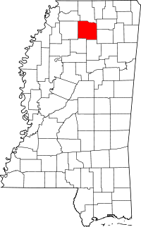 | |
| Town | ||
| CDP | ||
| Other unincorporated communities | ||
| Ghost town | ||