Orleans, Indiana
| Orleans, Indiana | |
|---|---|
| Town | |
|
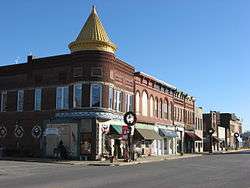
Orleans' business district | |
| Motto: "Dogwood Capital Of Indiana" | |
 Location of Orleans in the state of Indiana | |
| Coordinates: 38°39′40″N 86°27′12″W / 38.66111°N 86.45333°WCoordinates: 38°39′40″N 86°27′12″W / 38.66111°N 86.45333°W | |
| Country | United States |
| State | Indiana |
| County | Orange |
| Township | Orleans |
| Area[1] | |
| • Total | 1.71 sq mi (4.43 km2) |
| • Land | 1.71 sq mi (4.43 km2) |
| • Water | 0 sq mi (0 km2) |
| Elevation | 633 ft (193 m) |
| Population (2010)[2] | |
| • Total | 2,142 |
| • Estimate (2012[3]) | 2,135 |
| • Density | 1,252.6/sq mi (483.6/km2) |
| Time zone | Eastern (EST) (UTC-5) |
| • Summer (DST) | EDT (UTC-4) |
| ZIP code | 47452 |
| Area code(s) | 812 |
| FIPS code | 18-57024[4] |
| GNIS feature ID | 0440701[5] |
| Website |
www |
Orleans is a town in Orleans Township, Orange County, Indiana, United States. The population was 2,142 at the 2010 census.
History
Orleans was platted in 1815, and named in commemoration of the Battle of New Orleans.[6] A post office has been in operation at Orleans since 1823.[7]
Jenkins Place and Orleans Historic District are listed on the National Register of Historic Places.[8]
Geography
Orleans is located at 38°39′40″N 86°27′12″W / 38.66111°N 86.45333°W (38.660993, -86.453368).[9]
According to the 2010 census, Orleans has a total area of 1.71 square miles (4.43 km2), all land.[1]
Demographics
| Historical population | |||
|---|---|---|---|
| Census | Pop. | %± | |
| 1870 | 905 | — | |
| 1880 | 812 | −10.3% | |
| 1890 | 857 | 5.5% | |
| 1900 | 1,236 | 44.2% | |
| 1910 | 1,367 | 10.6% | |
| 1920 | 1,408 | 3.0% | |
| 1930 | 1,422 | 1.0% | |
| 1940 | 1,428 | 0.4% | |
| 1950 | 1,531 | 7.2% | |
| 1960 | 1,659 | 8.4% | |
| 1970 | 1,834 | 10.5% | |
| 1980 | 2,161 | 17.8% | |
| 1990 | 2,083 | −3.6% | |
| 2000 | 2,273 | 9.1% | |
| 2010 | 2,142 | −5.8% | |
| Est. 2015 | 2,129 | [10] | −0.6% |
2010 census
As of the census[2] of 2010, there were 2,142 people, 904 households, and 581 families residing in the town. The population density was 1,252.6 inhabitants per square mile (483.6/km2). There were 1,000 housing units at an average density of 584.8 per square mile (225.8/km2). The racial makeup of the town was 98.6% White, 0.1% African American, 0.3% Native American, 0.4% Asian, and 0.7% from two or more races. Hispanic or Latino of any race were 0.6% of the population.
There were 904 households of which 32.5% had children under the age of 18 living with them, 48.7% were married couples living together, 11.1% had a female householder with no husband present, 4.5% had a male householder with no wife present, and 35.7% were non-families. 31.5% of all households were made up of individuals and 15.8% had someone living alone who was 65 years of age or older. The average household size was 2.37 and the average family size was 2.98.
The median age in the town was 40.3 years. 24.5% of residents were under the age of 18; 8.3% were between the ages of 18 and 24; 23.8% were from 25 to 44; 25.4% were from 45 to 64; and 17.8% were 65 years of age or older. The gender makeup of the town was 47.2% male and 52.8% female.
2000 census
As of the census of 2000, there were 2,273 people, 922 households, and 614 families residing in the town. The population density was 1,449.3 people per square mile (559.0/km²). There were 992 housing units at an average density of 632.5 per square mile (244.0/km²). The racial makeup of the town was 98.77% White, 0.13% African American, 0.04% Native American, 0.13% from other races, and 0.92% from two or more races. Hispanic or Latino of any race were 1.01% of the population.
There were 922 households out of which 32.3% had children under the age of 18 living with them, 53.7% were married couples living together, 9.9% had a female householder with no husband present, and 33.4% were non-families. 30.0% of all households were made up of individuals and 16.8% had someone living alone who was 65 years of age or older. The average household size was 2.47 and the average family size was 3.08.
In the town the population was spread out with 28.4% under the age of 18, 8.1% from 18 to 24, 26.5% from 25 to 44, 20.2% from 45 to 64, and 16.8% who were 65 years of age or older. The median age was 36 years. For every 100 females there were 90.4 males. For every 100 females age 18 and over, there were 83.7 males.
The median income for a household in the town was $27,138, and the median income for a family was $35,150. Males had a median income of $26,630 versus $19,375 for females. The per capita income for the town was $14,476. About 12.3% of families and 17.2% of the population were below the poverty line, including 21.9% of those under age 18 and 16.3% of those age 65 or over.
References
- 1 2 "G001 - Geographic Identifiers - 2010 Census Summary File 1". United States Census Bureau. Retrieved 2015-07-17.
- 1 2 "American FactFinder". United States Census Bureau. Retrieved 2012-12-11.
- ↑ "Population Estimates". United States Census Bureau. Archived from the original on June 17, 2013. Retrieved 2013-06-25.
- ↑ "American FactFinder". United States Census Bureau. Retrieved 2008-01-31.
- ↑ "US Board on Geographic Names". United States Geological Survey. 2007-10-25. Retrieved 2008-01-31.
- ↑ History of Lawrence, Orange, and Washington Counties, Indiana: From the Earliest Time to the Present. Higginson Book Company. 1884. pp. 491–492.
- ↑ "Orange County". Jim Forte Postal History. Retrieved 19 September 2015.
- ↑ National Park Service (2010-07-09). "National Register Information System". National Register of Historic Places. National Park Service.
- ↑ "US Gazetteer files: 2010, 2000, and 1990". United States Census Bureau. 2011-02-12. Retrieved 2011-04-23.
- ↑ "Annual Estimates of the Resident Population for Incorporated Places: April 1, 2010 to July 1, 2015". Retrieved July 2, 2016.
- ↑ "Census of Population and Housing". Census.gov. Archived from the original on May 11, 2015. Retrieved June 4, 2015.
External links
Municipalities and communities of Orange County, Indiana, United States | ||
|---|---|---|
| Towns | ||
| Townships | ||
| Unincorporated communities |
| |
| Footnotes | ‡This populated place also has portions in an adjacent county or counties | |