Oregon Route 36
| ||||
|---|---|---|---|---|
 | ||||
| Route information | ||||
| Maintained by ODOT | ||||
| Length: | 51.58 mi[1] (83.01 km) | |||
| Component highways: | Mapleton–Junction City Highway No. 229 | |||
| Major junctions | ||||
| West end: |
| |||
| East end: |
| |||
| Location | ||||
| Counties: | Lane | |||
| Highway system | ||||
| ||||

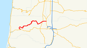
Oregon Route 36 is an Oregon state highway that runs between the city of Mapleton in the Oregon Coast Range, and the city of Junction City in the Willamette Valley. OR 36 traverses the Mapleton–Junction City Highway No. 229 of the Oregon state highway system.[2] The entire route of the highway is located within Lane County.
Route description
The western terminus of Oregon Route 36 is a junction with Oregon Route 126 in Mapleton. From Mapleton, the route heads due north through the Coast Range, then heads due east, following the course of the Siuslaw River. At the community of Swisshome it departs from the river, passing through the communities of Deadwood and Greenleaf, Triangle Lake, Blachly and Low Pass. As it emerges from the mountains, it passes through the Alderwood State Wayside, and descends into the Willamette Valley. It then passes through the communities of Goldson and Cheshire before ending just south of Junction City at an intersection with Oregon Route 99.
History
The highway was originally part of U.S. Route 28 and was the primary route between the Oregon Coast and the Eugene area; however, because of its winding nature, it was not suitable for high volumes of traffic. The commercial importance of the highway diminished greatly when a more direct route between Mapleton and Eugene—the present day alignment of Oregon Route 126—was constructed.
Major intersections
Milepoints are as reported by ODOT and do not necessarily reflect current mileage. Z indicates overlapping mileage due to construction longer than established route, and – indicates negative mileage behind established beginning point.[3] For routes traversing multiple named state highways, each milepoint is preceded by the corresponding state highway number. The entire route is in Lane County. [1]
| Location[1] | Milepoint[1] | Destinations | Notes | ||
|---|---|---|---|---|---|
| | 0.01 | ||||
| | 33.30 | Low Pass summit, elevation 1,022 feet (312 m) | |||
| Burp Hollow | 37.86 | Long Tom River | |||
| | 38.39 | Long Tom River | |||
| | 45.95 | Territorial Highway (OR 200 south) – Elmira, Veneta | Western end of concurrency with OR 200 | ||
| Cheshire | 47.41 | Territorial Highway (OR 200 north) | Eastern end of concurrency with OR 200 | ||
| | 47.81 | Long Tom River | |||
| | 51.59 | ||||
1.000 mi = 1.609 km; 1.000 km = 0.621 mi
| |||||
References
- 1 2 3 4 Road Inventory and Classification Services Unit. "Straightline Charts". Transportation Development Division, Oregon Department of Transportation. Retrieved October 25, 2015.
- Mapleton–Junction City Highway No. 229 (October 2011)
- ↑ Road Inventory and Classification Services Unit. "2012 Cross Reference Table of Highway Route Number to State Highway Number" (PDF). Transportation Development Division, Oregon Department of Transportation. Retrieved October 25, 2015.
- ↑ Road Inventory and Classification Services Unit. "Straightline Chart Legend" (PDF). Transportation Development Division, Oregon Department of Transportation. Retrieved August 29, 2015.