Siuslaw River
| Siuslaw River | |
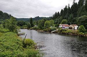 Siuslaw River at Mapleton | |
| Name origin: From a Yakonan name for a locality, tribe or chief[1] | |
| Country | United States |
|---|---|
| State | Oregon |
| County | Lane |
| Source | Central Oregon Coast Range |
| - location | about 10 miles (16 km) west of Cottage Grove |
| - elevation | 636 ft (194 m) [2] |
| - coordinates | 43°49′23″N 123°15′42″W / 43.82306°N 123.26167°W [3] |
| Mouth | Pacific Ocean |
| - location | Florence |
| - elevation | 0 ft (0 m) [3] |
| - coordinates | 44°01′01″N 124°08′14″W / 44.01694°N 124.13722°WCoordinates: 44°01′01″N 124°08′14″W / 44.01694°N 124.13722°W [3] |
| Length | 110 mi (177 km) [4] |
| Basin | 773 sq mi (2,002 km2) [5] |
| Discharge | for near Mapleton, 23.7 miles (38.1 km) from the mouth |
| - average | 1,974 cu ft/s (56 m3/s) [6] |
| - max | 49,400 cu ft/s (1,399 m3/s) |
| - min | 45 cu ft/s (1 m3/s) |
 Location of the mouth of the Siuslaw River in Oregon | |
| Wikimedia Commons: Siuslaw River | |
The Siuslaw River (/saɪˈjuːslɔː/ sy-YEW-slaw) is a river, about 110 miles (180 km) long, that flows to the Pacific Ocean coast of Oregon in the United States.[4] It drains an area of about 773 square miles (2,000 km2) in the Central Oregon Coast Range southwest of the Willamette Valley and north of the watershed of the Umpqua River.[5]
It rises in the mountains of southwestern Lane County, about 10 miles (16 km) west of Cottage Grove.[7] It flows generally west-northwest through the mountains, past Swisshome, entering the Pacific at Florence.[7] The head of tide is 26 miles (42 km) upstream.[8]
The valley of the river has been historically one of the productive timber regions in Oregon. The lower course of the river passes through Siuslaw National Forest.
The Coos Bay branch of the Coos Bay Rail Link crosses many bridges as it follows the narrow, winding valley of the Siuslaw River to the swing bridge at Cushman.
The river has historically been a spawning ground for Chinook and coho salmon. Although the Chinook population is substantial, coho numbers have declined from an annual average of 209,000 fish between 1889 and 1896 to just over 3,000 fish between 1990 and 1995.[9] The estuary of the river is surrounded by extensive wetlands that are a significant habitat for migratory birds along the coast.[10] It is one of the very few Western Oregon rivers where all major forks are undammed.[9]

See also
References
- ↑ McArthur, Lewis A.; Lewis L. McArthur (2003) [1928]. Oregon Geographic Names (7th ed.). Portland, Oregon: Oregon Historical Society Press. p. 883. ISBN 0-87595-277-1.
- ↑ Source elevation derived from Google Earth search using GNIS source coordinates.
- 1 2 3 "Siuslaw River". Geographic Names Information System. United States Geological Survey (USGS). November 28, 1980. Retrieved August 16, 2010.
- 1 2 United States Geological Survey (USGS). "United States Geological Survey Topographic Map". TopoQuest. Retrieved August 17, 2010. Map quadrangles show river mileage from mouth to source.
- 1 2 Ame, John (2007). "Siuslaw Watershed". Oregon State University. Retrieved November 26, 2015.
- ↑ "Water-Data Report 2010: 14307620 Siuslaw River near Mapleton, OR" (PDF). United States Geological Survey. Retrieved October 19, 2011.
- 1 2 Oregon Atlas & Gazetteer. Freeport, Maine: DeLorme Mapping. 1991. pp. 32, 40–41, 46. ISBN 0-89933-235-8.
- ↑ "Maintenance Dredging for the Siuslaw River Coastal Navigation Project (Draft Environmental Assessment)" (PDF). U.S. Army Corps of Engineers. April 2010. p. 9. Retrieved October 19, 2011.
- 1 2 "A Watershed Assessment for the Siuslaw Basin". Ecotrust. 2002. Retrieved October 19, 2011.
- ↑ "Bringing Back the Tides to Estuary Wetlands". Currents. McKenzie River Trust (Winter/Spring): 1. 2011. Retrieved October 19, 2011.
External links
-
 Media related to Siuslaw River at Wikimedia Commons
 - Oregon Coastal Atlas: Siuslaw River estuary