Onie, West Virginia
| Onie | |
|---|---|
| Unincorporated community | |
 Onie  Onie Location within the state of West Virginia | |
| Coordinates: 39°37′11″N 80°37′51″W / 39.61972°N 80.63083°WCoordinates: 39°37′11″N 80°37′51″W / 39.61972°N 80.63083°W | |
| Country | United States |
| State | West Virginia |
| County | Wetzel |
| Elevation | 902 ft (275 m) |
| Time zone | Eastern (EST) (UTC-5) |
| • Summer (DST) | EDT (UTC-4) |
| GNIS ID | 1717809[1] |
Onie was an unincorporated community in Wetzel County, West Virginia. It was also known as Unie.
Near Wileyville, Onie was located at the mouth of Honey Run which is a tributary of Little Fishing Creek.[2] Although this town appeared on a few maps, Onie disappeared shortly after it first appeared. According to local memories, Onie had a bar, a blacksmith, and a hotel.[2]
Around 1900, Onie was an oil boom town. Oil production peaked in West Virginia by 1900, when the state ranked second in oil production, and Onie declined after that.[2] As of 2008, East Resources still had a field office and wells at this location, but the fields had been used for hay instead of oil for a long time after Onie vanished.
References
- ↑ U.S. Geological Survey Geographic Names Information System: Onie, West Virginia
- 1 2 3 Dorsey, Brenda. "It's A Gasser: The First Wetzel Oil and Gas Boom", The Wetzel Chronicle (April 2, 2008).
Municipalities and communities of Wetzel County, West Virginia, United States | ||
|---|---|---|
| Cities | 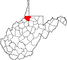 | |
| Towns | ||
| CDPs | ||
| Unincorporated communities |
| |
| Ghost towns | ||
| Footnotes | ‡This populated place also has portions in an adjacent county or counties | |