Knob Fork, West Virginia
| Knob Fork | |
|---|---|
| Unincorporated community | |
 Knob Fork  Knob Fork Location within the state of West Virginia | |
| Coordinates: 39°38′55″N 80°32′48″W / 39.64861°N 80.54667°WCoordinates: 39°38′55″N 80°32′48″W / 39.64861°N 80.54667°W | |
| Country | United States |
| State | West Virginia |
| County | Wetzel |
| Time zone | Eastern (EST) (UTC-5) |
| • Summer (DST) | EDT (UTC-4) |
Knob Fork is an unincorporated community in Wetzel County, West Virginia, United States. It lies at an elevation of 1050 feet (320 m). Other names for the community include Geaneytown, Jolliff, Jolliffe, Jolliffes Store, Knobfork Store, Sugar Run, and Uniontown.[1] The present name is after nearby Knob Fork creek.[2]
References
- ↑ U.S. Geological Survey Geographic Names Information System: Knob Fork, West Virginia
- ↑ Kenny, Hamill (1945). West Virginia Place Names: Their Origin and Meaning, Including the Nomenclature of the Streams and Mountains. Piedmont, WV: The Place Name Press. pp. 354–355.
Municipalities and communities of Wetzel County, West Virginia, United States | ||
|---|---|---|
| Cities | 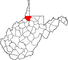 | |
| Towns | ||
| CDPs | ||
| Unincorporated communities |
| |
| Ghost towns | ||
| Footnotes | ‡This populated place also has portions in an adjacent county or counties | |
This article is issued from Wikipedia - version of the 7/28/2016. The text is available under the Creative Commons Attribution/Share Alike but additional terms may apply for the media files.