Old U.S. Route 71 (Jenny Lind, Arkansas)
|
Old US 71-Jenny Lind Segment | |
 | |
| Nearest city | Jenny Lind, Arkansas |
|---|---|
| Area | 1.8 acres (0.73 ha) |
| Built | 1927 |
| Architectural style | highway |
| MPS | Arkansas Highway History and Architecture MPS |
| NRHP Reference # | 09000738[1] |
| Added to NRHP | September 23, 2009 |
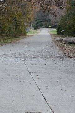
The Old US 71-Jenny Lind Segment is a stretch of historic road pavement southeast of Jenny Lind, Arkansas. It consists of a bypassed section of U.S. Route 71 (US 71) that is now designated Doraul Acres Lane. It extends for about 0.75 miles (1.21 km), traveling roughly parallel to, and south of, the current alignment of US 71 between Hidden Valley Way and Shadow Lake Drive. It is concrete pavement 18 feet (5.5 m) wide with no shoulder, and there is a single concrete slab bridge, which spans Bear Creek. This roadway section was built 1927-29, when US 71 was first built. It was bypassed in 1959.[2]
The roadway was listed on the National Register of Historic Places in 2009.[1]
See also
References
- 1 2 National Park Service (2010-07-09). "National Register Information System". National Register of Historic Places. National Park Service.
- ↑ "NRHP nomination for Old US 71-Jenny Lind Segment" (PDF). Arkansas Preservation. Retrieved 2015-04-27.
| Topics | |
|---|---|
| Lists by states |
|
| Lists by insular areas | |
| Lists by associated states | |
| Other areas | |
| |
This article is issued from Wikipedia - version of the 6/24/2016. The text is available under the Creative Commons Attribution/Share Alike but additional terms may apply for the media files.