Okreek, South Dakota
| Okreek | |
|---|---|
| Unincorporated community | |
 Okreek  Okreek Location within the state of South Dakota | |
| Coordinates: 43°21′44″N 100°23′9″W / 43.36222°N 100.38583°WCoordinates: 43°21′44″N 100°23′9″W / 43.36222°N 100.38583°W | |
| Country | United States |
| State | South Dakota |
| County | Todd |
| Population (2010) | |
| • Total | 269 |
| Time zone | Central (CST) (UTC-6) |
| • Summer (DST) | CDT (UTC-5) |
| ZIP codes | 57563 |
Okreek is an unincorporated community in Todd County, South Dakota, United States. As of the 2010 Census, the population was 269. The town is wholly within the jurisdiction of the Rosebud Indian Reservation, and the populace is almost entirely Sioux-American. Okreek consists primarily of two long blocks of inhabited tract housing, and has about 30 private telephone subscribers within town limits. There is also an elementary school and a Post Office which has been assigned the ZIP Code of 57563.[1]
The name Okreek is a corruption of Oak Creek, a stream near the town site.[2]
References
- ↑ "Okreek, SD ZIP Codes". SD HomeTownLocator. HTL, Inc. Retrieved 2008-09-12.
- ↑ Federal Writers' Project (1940). South Dakota place-names, v.1-3. University of South Dakota. p. 52.
Municipalities and communities of Todd County, South Dakota, United States | ||
|---|---|---|
| City | 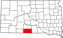 | |
| Town | ||
| CDPs |
| |
| Unincorporated communities | ||
| Indian reservation | ||
| Footnotes | ‡This populated place also has portions in an adjacent county or counties | |
This article is issued from Wikipedia - version of the 7/31/2016. The text is available under the Creative Commons Attribution/Share Alike but additional terms may apply for the media files.