Okegawa, Saitama
| Okegawa 桶川市 | |||
|---|---|---|---|
| City | |||
|
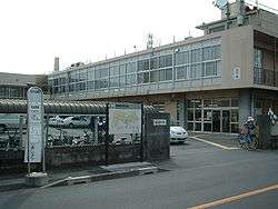
Okegawa city hall | |||
| |||
 Location of Okegawa in Saitama Prefecture | |||
 Okegawa Location of Okegawa in Saitama Prefecture | |||
| Coordinates: 36°0′20.6″N 139°32′33.7″E / 36.005722°N 139.542694°ECoordinates: 36°0′20.6″N 139°32′33.7″E / 36.005722°N 139.542694°E | |||
| Country | Japan | ||
| Region | Kantō | ||
| Prefecture | Saitama Prefecture | ||
| Area | |||
| • Total | 25.35 km2 (9.79 sq mi) | ||
| Population (February 2016) | |||
| • Total | 74,000 | ||
| • Density | 2,920/km2 (7,600/sq mi) | ||
| Time zone | Japan Standard Time (UTC+9) | ||
| - Tree | Zelkova serrata | ||
| - Flower | Azalea | ||
| Website | Official website | ||


Okegawa (桶川市 Okegawa-shi) is a city located in southern Saitama Prefecture, in the central Kantō region of Japan. As of 1 February 2016, the city had an estimated population of 74,000 and a population density of 2920 persons per km². Its total area was 25.35 km².
Geography
Okegawa is located in east-central Saitama Prefecture. The Arakawa River flows through the city.
Surrounding municipalities
History
During the Edo period, Okegawa-shuku was the sixth of the sixty-nine stations of the Nakasendō.
The modern town of Okegawa was established within Iruma District with the establishment of the municipalities system on April 1, 1889. On January 1, 1955, Okegawa annexed the neighboring village of Kano, followed by the village of Kawataya on March 10, 1955. Okegawa was elevated to city status on November 3, 1970.
Economy
Okegawa was traditionally known as a center for safflower production. The city now has a mixed economy, with a signification portion of its population commuting to Tokyo or Saitama city for work.
Education
- Okegawa has seven elementary schools, four middle schools and three high schools and three special education schools.
Transportation
Railway
Highway
- Ken-Ō Expressway – Okegawa-Kita IC, Okegawa-Kano IC
- Japan National Route 17
Local attractions
- Okegawa-shuku
- Honda Airport
- Kawataya Kofun cluster
- Okegawa Gion Festival
Noted people from Okegawa
- Masahiro Motoki, actor
- Michiyo Tsujimura, agricultural chemist
External links
![]() Media related to Okegawa, Saitama at Wikimedia Commons
Media related to Okegawa, Saitama at Wikimedia Commons
- Official website (Japanese)
| Wards of Saitama | ||
|---|---|---|
| Core cities | ||
| Special cities | ||
| Cities | ||
| Chichibu District | ||
| Hiki District | ||
| Iruma District | ||
| Kitaadachi District | ||
| Kitakatsushika District | ||
| Kodama District | ||
| Minamisaitama District | ||
| Ōsato District | ||