Ohio State Route 726
| ||||
|---|---|---|---|---|
 | ||||
| Route information | ||||
| Maintained by ODOT | ||||
| Length: | 14.21 mi[1] (22.87 km) | |||
| Existed: | 1937 – present | |||
| Major junctions | ||||
| South end: |
| |||
|
| ||||
| North end: |
| |||
| Location | ||||
| Counties: | Darke, Preble | |||
| Highway system | ||||
| ||||

State Route 726 (SR 726) is a north–south state highway in western Ohio, a U.S. state. The southern terminus of the state route is at a T-intersection with US 127 about 1 mile (1.6 km) north of the city limits of Eaton. The northern terminus of SR 726 is at a signalized intersection with SR 121 in downtown New Madison.
Route description
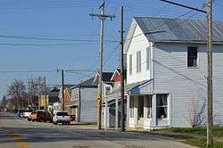
As Main Street in Eldorado
SR 726 runs through northern Preble County and southern Darke County. No portion of this highway is inclusive within the National Highway System.[2]
History
Created in 1937 along the alignment that it occupies to this day between US 127 and SR 121, SR 726 has not experienced any changes of major significance to its routing since inception.[3][4]
Major intersections
| County | Location | mi[1] | km | Destinations | Notes |
|---|---|---|---|---|---|
| Preble | Washington Township | 0.00 | 0.00 | ||
| Monroe Township | 4.83 | 7.77 | |||
| Darke | Butler Township | 11.41 | 18.36 | ||
| New Madison | 14.21 | 22.87 | |||
| 1.000 mi = 1.609 km; 1.000 km = 0.621 mi | |||||
References
- 1 2 Ohio Department of Transportation. "Technical Services Straight Line Diagrams". Retrieved 2010-11-04.
- ↑ National Highway System: Ohio (PDF) (Map). Federal Highway Administration. December 2003. Retrieved 2010-11-04.
- ↑ Ohio State Map (Map). Ohio Department of Transportation. 1936.
- ↑ Ohio State Map (Map). Ohio Department of Transportation. 1937.
This article is issued from Wikipedia - version of the 4/12/2016. The text is available under the Creative Commons Attribution/Share Alike but additional terms may apply for the media files.