Ohio State Route 603
| ||||
|---|---|---|---|---|
 | ||||
| Route information | ||||
| Maintained by ODOT | ||||
| Length: | 33.58 mi[1] (54.04 km) | |||
| Existed: | 1938[2][3] – present | |||
| Major junctions | ||||
| South end: |
| |||
|
| ||||
| North end: |
| |||
| Location | ||||
| Counties: | Richland, Ashland | |||
| Highway system | ||||
| ||||

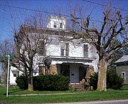
The Silas Ferrell House, a historic site on State Route 603 at Shiloh
State Route 603 (SR 603) is a north–south state highway in the northern portion of the U.S. state of Ohio. Its southern terminus is at State Route 95 near Perrysville, and its northern terminus is at State Routes 61 and 98 in Plymouth along the Baseline Road that separates Huron County and Richland County, and subsequently the southern boundary of the Firelands and Connecticut Western Reserve.
History
SR 603 was commissioned in 1938 along its current alignment, between Shiloh and SR 95.[2][3] Between 1953 and 1955 the route was paved.[4][5] The route was extended west to Plymouth between 1959 and 1961.[6][7]
Major intersections
| County | Location | mi[1] | km | Destinations | Notes | |||
|---|---|---|---|---|---|---|---|---|
| Richland | Monroe Township | 0.00 | 0.00 | |||||
| 4.72 | 7.60 | |||||||
| Ashland | Mifflin Township | 9.98 | 16.06 | Eastern terminus of SR 430 | ||||
| 10.60 | 17.06 | |||||||
| Richland |
No major junctions | |||||||
| Ashland | Milton Township | 13.63 | 21.94 | |||||
| Richland | Weller Township | 18.71 | 30.11 | |||||
| 19.09 | 30.72 | |||||||
| Blooming Grove Township | 23.11 | 37.19 | ||||||
| Richland–Huron county line | Plymouth | 33.58 | 54.04 | |||||
| 1.000 mi = 1.609 km; 1.000 km = 0.621 mi | ||||||||
References
- 1 2 Ohio Department of Transportation. "Technical Services Straight Line Diagrams". Retrieved August 31, 2013.
- 1 2 Ohio Department of Highways (1937). Official Highway Map of Ohio (MrSID) (Map). 1:633,600. Columbus: Ohio Department of Highways. OCLC 5673562, 16960304. Retrieved September 17, 2013.
- 1 2 Ohio Department of Highways (1938). Official Highway Map of Ohio (MrSID) (Map). 1:633,600. Columbus: Ohio Department of Highways. OCLC 5673562, 7453129. Retrieved September 17, 2013.
- ↑ Ohio Department of Highways (1953). Official Highway Map of Ohio (MrSID) (Map). 1:633,600. Columbus: Ohio Department of Highways. OCLC 5673562, 7448735. Retrieved September 17, 2013.
- ↑ Ohio Department of Highways (1955). Official Highway Map of Ohio (MrSID) (Map). 1:633,600. Columbus: Ohio Department of Highways. OCLC 5673562, 7448742. Retrieved September 17, 2013.
- ↑ Ohio Department of Highways (1959). Official Highway Map of Ohio (MrSID) (Map) (1959–60 ed.). 1:633,600. Columbus: Ohio Department of Highways. OCLC 5673562, 13687960. Retrieved September 17, 2013.
- ↑ Ohio Department of Highways (1961). Official Highway Map of Ohio (MrSID) (Map). 1:633,600. Columbus: Ohio Department of Highways. OCLC 5673562, 54667348. Retrieved September 17, 2013.
This article is issued from Wikipedia - version of the 8/28/2014. The text is available under the Creative Commons Attribution/Share Alike but additional terms may apply for the media files.