Oakhurst, Oklahoma
| Oakhurst, Oklahoma | |
|---|---|
| Census-designated place | |
 Location within Creek County, and the state of Oklahoma | |
| Coordinates: 36°4′45″N 96°3′5″W / 36.07917°N 96.05139°WCoordinates: 36°4′45″N 96°3′5″W / 36.07917°N 96.05139°W | |
| Country | United States |
| State | Oklahoma |
| Counties | Tulsa, Creek |
| Area | |
| • Total | 5.7 sq mi (14.7 km2) |
| • Land | 5.7 sq mi (14.7 km2) |
| • Water | 0.0 sq mi (0.0 km2) |
| Elevation | 761 ft (232 m) |
| Population (2010) | |
| • Total | 2,185 |
| • Density | 385/sq mi (148.8/km2) |
| Time zone | Central (CST) (UTC-6) |
| • Summer (DST) | CDT (UTC-5) |
| ZIP code | 74050 |
| Area code(s) | 539/918 |
| FIPS code | 40-53350[1] |
| GNIS feature ID | 1096147[2] |
Oakhurst is an unincorporated community and census-designated place (CDP) in Creek and Tulsa counties in the U.S. state of Oklahoma. The population was 2,185 at the 2010 census, a loss of 20 percent from 2,731 at the 2000 census.[3]
Geography
Oakhurst is located in western Tulsa County and northeastern Creek County at 36°4′45″N 96°3′5″W / 36.07917°N 96.05139°W (36.079291, -96.051444).[4] It is bordered by Tulsa to the east, Sand Springs to the northwest, and Sapulpa to the south. Interstate 44 passes through the community, with access from exits 221 and 222. Downtown Tulsa is 7 miles (11 km) to the northeast via Interstate 244, which branches from I-44 in northeast Oakhurst.
According to the United States Census Bureau, the CDP has a total area of 5.7 square miles (14.7 km2), all land.[5] The CDP has lost area over time as the surrounding cities expand; in 2000 the area of Oakhurst was 6.7 square miles (17.4 km2).
Demographics
As of the census[1] of 2000, there were 2,731 people, 1,067 households, and 767 families residing in the CDP. The population density was 406.8 people per square mile (157.1/km²). There were 1,191 housing units at an average density of 177.4 per square mile (68.5/km²). The racial makeup of the CDP was 81.03% White, 1.28% African American, 10.00% Native American, 0.55% Asian, 0.07% Pacific Islander, 0.73% from other races, and 6.33% from two or more races. Hispanic or Latino of any race were 2.49% of the population.
There were 1,067 households out of which 28.2% had children under the age of 18 living with them, 55.9% were married couples living together, 10.4% had a female householder with no husband present, and 28.1% were non-families. 24.7% of all households were made up of individuals and 9.0% had someone living alone who was 65 years of age or older. The average household size was 2.56 and the average family size was 3.04.
In the CDP the population was spread out with 24.6% under the age of 18, 7.8% from 18 to 24, 28.2% from 25 to 44, 26.4% from 45 to 64, and 12.9% who were 65 years of age or older. The median age was 38 years. For every 100 females there were 97.8 males. For every 100 females age 18 and over, there were 97.5 males.
The median income for a household in the CDP was $34,858, and the median income for a family was $41,104. Males had a median income of $30,227 versus $20,453 for females. The per capita income for the CDP was $15,125. About 6.7% of families and 8.9% of the population were below the poverty line, including 3.9% of those under age 18 and 4.6% of those age 65 or over.
References
- 1 2 "American FactFinder". United States Census Bureau. Archived from the original on September 11, 2013. Retrieved 2008-01-31.
- ↑ "US Board on Geographic Names". United States Geological Survey. 2007-10-25. Retrieved 2008-01-31.
- ↑ CensusViewer:Population of the City of Oakhurst, Oklahoma
- ↑ "US Gazetteer files: 2010, 2000, and 1990". United States Census Bureau. 2011-02-12. Retrieved 2011-04-23.
- ↑ "Geographic Identifiers: 2010 Demographic Profile Data (G001): Oakhurst CDP, Oklahoma". U.S. Census Bureau, American Factfinder. Retrieved March 9, 2015.
Municipalities and communities of Creek County, Oklahoma, United States | ||
|---|---|---|
| Cities | 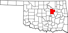 | |
| Towns | ||
| CDP | ||
| Unincorporated communities | ||
| Ghost town | ||
| Footnotes | ‡This populated place also has portions in an adjacent county or counties | |
Municipalities and communities of Tulsa County, Oklahoma, United States | ||
|---|---|---|
| Cities |  | |
| Towns | ||
| CDPs | ||
| Unincorporated community | ||
| Footnotes | ‡This populated place also has portions in an adjacent county or counties | |