Nyamagana District
| Nyamagana District | |
|---|---|
| District | |
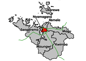 Nyamagana District's location within Mwanza Region. Trunk roads in green. | |
| Coordinates: 02°35′S 032°55′E / 2.583°S 32.917°ECoordinates: 02°35′S 032°55′E / 2.583°S 32.917°E | |
| Country | Tanzania |
| Region | Mwanza Region |
| Population (2012) | |
| • Total | 363,452 |
Nyamagana District is one of the seven districts of the Mwanza Region of Tanzania. It is bordered to the north by Ilemela District, to the east by Magu District, to the south by Misungwi District and to the west by the Mwanza Bay of Lake Victoria. Part of the region's capital, the town of Mwanza, is within Nyamagana District. The district commission's office is scheduled to be re-located to the Mkolani area of Mwanza town, but currently it is still in the old city hall in the centre of town.
As of 2012, the population of the Nyamagana District was 363,452.[1]
Wards
As of 2012, Nyamagana District was divided into twelve wards. [1]
2012 wards
|
|
|
References
- 1 2 "Census 2012". National Bureau of Statistics. Retrieved 9 December 2015.
This article is issued from Wikipedia - version of the 12/10/2015. The text is available under the Creative Commons Attribution/Share Alike but additional terms may apply for the media files.