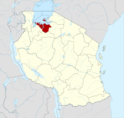
Mwanza Region
| Mwanza Region Mkoa wa Mwanza (Swahili) | |
|---|---|
| Region | |
|
| |
 Regional map before partition in 2012 | |
| Country | Tanzania |
| Zone | Lake |
| Capital | Mwanza |
| Government | |
| • Regional Commissioner | Evarist Ndikilo |
| Area | |
| • Total | 9,467 km2 (3,655 sq mi) |
| Population (2012) | |
| • Total | 2,772,509 |
| • Density | 290/km2 (760/sq mi) |
| Time zone | EAT (UTC+3) |
| Postcode | 33xxx |
| Area code(s) | 028 |
| Website |
mwanza |
Mwanza Region is one of Tanzania's 30 administrative regions. The regional capital is Mwanza.
The neighbouring regions are Geita to the west, Shinyanga to the south, and Simiyu to the east. Furthermore, Lake Victoria borders the region's north frontier.
The regional commissioner of the Mwanza Region is John Mongella.[1]
Districts
The region is administratively divided into seven districts:
| Districts of Mwanza Region | |||||
|---|---|---|---|---|---|
| Map | District | Population (2012) | |||
 |
Ilemela | 343,001 | |||
| Kwimba | 406,509 | ||||
| Magu | 299,759 | ||||
| Misungwi | 351,607 | ||||
| Nyamagana | 363,452 | ||||
| Sengerema | 663,034 | ||||
| Ukerewe | 345,147 | ||||
| Total | 2,772,509 | ||||
Population and area
According to the 2012 national census, the Mwanza Region had a population of 2,772,509, which was lower than the pre-census projection of 3,771,067.[2]:page 2 For 2002-2012, the region's 3.0 percent average annual population growth rate was the eighth highest in the country.[2]:page 4 It was also the sixth most densely populated region with 293 people per square kilometer.[2]:page 6
As of 2007, the region covered an area of 20,095 square kilometres (7,759 sq mi) of dry land;[3] however, parts of the region went to establish the Geita Region in 2012.
Culture
The Mwanza Region is occupied by various tribal groups, included the Wasukuma, the Wakerewe, Wakara and Wazinza. Mwanza city's Makongoro Road is named after a prominent Sukuma chief who controlled the area in the late 1800s. Under British rule, the region was one district in the Lake Province, which became the Lake Region after independence. In 1963, the Mwanza Region was created.
Wasukuma tribe is the major tribe occupying the Mwanza Region, the other region that is occupied by Wasukuma is Shinyanga Region.
Transport
Mwanza region is well connected by road, rail, water and air transport.
Roads
Paved trunk road T4 from Musoma to Bukoba passes through the district from east to west. While paved trunk road T8 from Mwanza to Shinyanga passes through the region from north to south.[4]
Railways
The Mwanza branch of the Central Line railway passes through the region on its way from Mwanza to Tabora and there are several stations within the region's borders.[5]
Water transport
Ferries connect Ukerewe Island with Mwanza city. Other ferries operate between Mwanza and Sengerema District.
Air transport
Mwanza International Airport is located within the region's boundaries, in the city of Mwanza.
References
- ↑ Kitabu cha Mawasiliano Serikalini, Tanzania Government Directory, 2012, page 181
- 1 2 3 Population Distribution by Administrative Units, United Republic of Tanzania, 2013
- ↑ "Socio-Economic Profile of Mwanza Region" (PDF). The Planning Commission, Dar es Salaam, and The Regional Commissioner's Office, Mwanza. October 1997. Archived from the original (PDF) on 31 May 2004.
- ↑ "Mwanza Roads Network" (PDF). Tanroads. Retrieved 9 December 2015.
- ↑ "Railways Network". Tanzania Railways Limited. Retrieved 7 March 2016.
External links
- Government site on Mwanza region
- Mwanza Women Development
- St Augustine University of Tanzania at RC.net
| Mainland | ||
|---|---|---|
| Zanzibar | ||
Coordinates: 2°45′S 32°45′E / 2.750°S 32.750°E