Magu District
| Magu District | |
|---|---|
| District | |
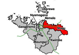 Magu District's location within Mwanza Region. Trunk roads in green. | |
| Coordinates: 02°35′S 033°26′E / 2.583°S 33.433°ECoordinates: 02°35′S 033°26′E / 2.583°S 33.433°E | |
| Country | Tanzania |
| Region | Mwanza Region |
| UFI | -2567436 |
Magu District[1] is one of the seven districts of the Mwanza Region of Tanzania, East Africa. Its administrative centre is the town of Magu on the Simiyu River. It is bordered to the north by Lake Victoria and Busega District, to the east by Bariadi District, to the south by Itilima District, Maswa District, Kwimba District and Misungwi District, and to the west by the city of Mwanza, which consists of Nyamagana District and Ilemela District.
As of 2012, the population of Magu was 299,759.[2] This is less than the district's population in 2002, when the number was 416,113,[3] due to the fact that the district was split up in 2012 and about half of the original Magu district is now part of the new Busega District, Simiyu Region.[4]
Administrative subdivisions
Constituencies
For parliamentary elections, Tanzania is divided into constituencies. As of the 2010 elections Magu District had two constituencies:[5]
- Busega Constituency
- Magu Constituency
Divisions
As of 2012, Magu District was administratively divided into four divisions:[2]
- Itumbili
- Kahangara
- Ndagalu
- Sanjo
Wards
As of 2002, Magu District was administratively divided into twenty-seven wards.[3] As of 2012, it was divided into 18 wards having undergone considerable reorganisation.[6]
2002 wards
The twenty-seven wards in 2002:
|
|
|
2012 wards
|
|
|
Notes
- ↑ Magu District (Approved) at GEOnet Names Server, United States National Geospatial-Intelligence Agency
- 1 2 "Census 2012". National Bureau of Statistics. Retrieved 9 December 2015.
- 1 2 "2002 Population and Housing Census: General Report: Mwanza: Magu". Archived from the original on 18 March 2004.
- ↑ "Tanzania: New Regions, Districts Will Facilitate Service Provision". All Africa. Retrieved 1 December 2015.
- ↑ "Organisations located in Magu District - Tanzania". African Development Information.
- ↑ "Postcodes Mwanza Region 33000" (PDF). Tanzania Communications Regulatory Authority (TCRA). 2012.