Nus
For other uses, see NUS.
| Nus | ||
|---|---|---|
| Comune | ||
| Comune di Nus Commune de Nus | ||
 | ||
| ||
 Nus Location of Nus in Italy | ||
| Coordinates: 45°44′N 7°28′E / 45.733°N 7.467°ECoordinates: 45°44′N 7°28′E / 45.733°N 7.467°E | ||
| Country | Italy | |
| Region | Valle d'Aosta | |
| Province / Metropolitan city | none | |
| Frazioni | Arlian, Blavy, Champagne, Clémensod, Cret, Fognier, Issologne, La Plantaz, Lavanche, Lignan, Mandollaz, Marsan, Martinet, Mazod, Messigné, Petit-Fénis, Pesse, Plane, Plaisant, Plantayes, Porliod, Praille, Praz, Ronchettes, Rovarey, Sacquignod, Tolasèche, Val, Vénoz | |
| Area | ||
| • Total | 57.38 km2 (22.15 sq mi) | |
| Elevation | 529 m (1,736 ft) | |
| Population (1 January 2007)[1] | ||
| • Total | 2,755 | |
| • Density | 48/km2 (120/sq mi) | |
| Demonym(s) | Neuveins | |
| Time zone | CET (UTC+1) | |
| • Summer (DST) | CEST (UTC+2) | |
| Postal code | 11020 | |
| Dialing code | 0165 | |
| Patron saint | Hilary of Poitiers | |
| Saint day | 13 January | |
| Website | Official website | |
.svg.png)
See also: Nuss (disambiguation)
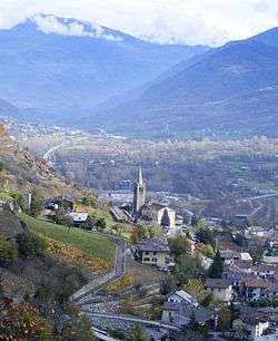
Nus is a town and comune in the Aosta Valley region of northern Italy.
See also
- Vien de Nus, Italian wine grape that is a specialty of the region.
References
This article is issued from Wikipedia - version of the 9/22/2016. The text is available under the Creative Commons Attribution/Share Alike but additional terms may apply for the media files.