Norwood Young America, Minnesota
| Norwood Young America | |
|---|---|
| City | |
 Location of the city of Norwood Young America within Carver County, Minnesota | |
| Coordinates: 44°46′N 93°55′W / 44.767°N 93.917°W | |
| Country | United States |
| State | Minnesota |
| County | Carver |
| Merged | 1997 |
| Government | |
| • Mayor | Tina Diedrick |
| Area[1] | |
| • Total | 2.52 sq mi (6.53 km2) |
| • Land | 2.52 sq mi (6.53 km2) |
| • Water | 0 sq mi (0 km2) |
| Elevation | 991 ft (302 m) |
| Population (2010)[2] | |
| • Total | 3,549 |
| • Estimate (2012[3]) | 3,583 |
| • Density | 1,408.3/sq mi (543.7/km2) |
| Time zone | CST (UTC-6) |
| • Summer (DST) | CDT (UTC-5) |
| ZIP codes | 55368, 55397, 55473 plus 20-some more. |
| Area code(s) | 952 |
| FIPS code | 27-47520 |
| GNIS feature ID | 1764916[4] |
| Website | www.cityofnya.com |
Norwood Young America is a city in Carver County, Minnesota, United States. The population was 3,549 at the 2010 census.[5]
History
Young America was platted in 1856.[6] Norwood was platted in 1872.[7]
The present city of Norwood Young America was formed on January 1, 1997 when the cities of Norwood and Young America merged.[8] The city is usually referred to in speech by its abbreviation, NYA.
Prior to the 1997 merger, Young America was known as being one of the two cities where correspondences for consumer product contests went to, the other being Blair, Nebraska.
Geography

According to the United States Census Bureau, the city has a total area of 2.52 square miles (6.53 km2), all of it land.[1]
U.S. Highway 212, Minnesota Highway 5, and Minnesota Highway 25 are three of the main routes in the community.
Demographics
| Historical population | |||
|---|---|---|---|
| Census | Pop. | %± | |
| 2000 | 3,108 | — | |
| 2010 | 3,549 | 14.2% | |
| Est. 2015 | 3,677 | [9] | 3.6% |
2010 census
As of the census[2] of 2010, there were 3,549 people, 1,389 households, and 954 families residing in the city. The population density was 1,408.3 inhabitants per square mile (543.7/km2). There were 1,472 housing units at an average density of 584.1 per square mile (225.5/km2). The racial makeup of the city was 95.2% White, 0.4% African American, 0.2% Native American, 0.5% Asian, 2.4% from other races, and 1.2% from two or more races. Hispanic or Latino of any race were 4.1% of the population.
There were 1,389 households of which 35.9% had children under the age of 18 living with them, 53.1% were married couples living together, 10.5% had a female householder with no husband present, 5.0% had a male householder with no wife present, and 31.3% were non-families. 25.6% of all households were made up of individuals and 11.7% had someone living alone who was 65 years of age or older. The average household size was 2.55 and the average family size was 3.05.
The median age in the city was 35.8 years. 27.2% of residents were under the age of 18; 7.3% were between the ages of 18 and 24; 28.3% were from 25 to 44; 25.8% were from 45 to 64; and 11.5% were 65 years of age or older. The gender makeup of the city was 49.5% male and 50.5% female.
2000 census

As of the census of 2000, there were 3,108 people, 1,171 households, and 833 families residing in the city. The population density was 1,855.8 people per square mile (718.6/km²). There were 1,201 housing units at an average density of 717.1 per square mile (277.7/km²). The racial makeup of the city was 98.10% White, 0.13% African American, 0.45% Native American, 0.42% Asian, 0.51% from other races, and 0.39% from two or more races. Hispanic or Latino of any race were 2.64% of the population.
There were 1,171 households out of which 40.5% had children under the age of 18 living with them, 58.2% were married couples living together, 8.5% had a female householder with no husband present, and 28.8% were non-families. 24.2% of all households were made up of individuals and 11.7% had someone living alone who was 65 years of age or older. The average household size was 2.65 and the average family size was 3.19.
In the city the population was spread out with 29.4% under the age of 18, 9.9% from 18 to 24, 31.0% from 25 to 44, 18.0% from 45 to 64, and 11.7% who were 65 years of age or older. The median age was 33 years. For every 100 females there were 93.9 males. For every 100 females age 18 and over, there were 92.9 males.
The median income for a household in the city was $46,152, and the median income for a family was $54,792. Males had a median income of $36,292 versus $26,837 for females. The per capita income for the city was $18,431. About 2.7% of families and 5.6% of the population were below the poverty line, including 4.7% of those under age 18 and 8.2% of those age 65 or over.
Business
In 1973, the Dile Corporation moved to Young America, and changed its name to Young America Corporation. They are one of the largest employers in the town, processing rebate, coupon, and other marketing programs for businesses. They receive a great deal of mail, enough that this small town has over 20 zip codes assigned to it. A main one is 55555.
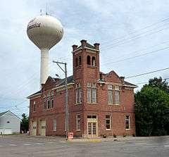
National Register of Historic Places gallery
Norwood Young America has several buildings listed on the National Register of Historic Places.
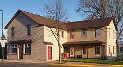
 Young America City Hall, now converted to a live/work space.
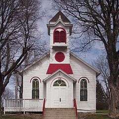
 Winter Saloon (1890)
Arts and culture
Norwood Young America is home to Stiftungsfest, Minnesota's oldest festival (dating to 1861).
The Minnesota Historical Society has a Young America photograph collection, ca. 1913-1927.
External links
References
- 1 2 "US Gazetteer files 2010". United States Census Bureau. Retrieved 2012-11-13.
- 1 2 "American FactFinder". United States Census Bureau. Retrieved 2012-11-13.
- ↑ "Population Estimates". United States Census Bureau. Retrieved 2013-05-28.
- ↑ "US Board on Geographic Names". United States Geological Survey. 2007-10-25. Retrieved 2008-01-31.
- ↑ "2010 Census Redistricting Data (Public Law 94-171) Summary File". American FactFinder. United States Census Bureau. Retrieved 27 April 2011.
- ↑ Upham, Warren (1920). Minnesota Geographic Names: Their Origin and Historic Significance. Minnesota Historical Society. p. 84.
- ↑ Upham, Warren (1920). Minnesota Geographic Names: Their Origin and Historic Significance. Minnesota Historical Society. p. 83.
- ↑ "Population Estimates 1990s Geographic Change Notes: Minnesota". U.S. Census Bureau. Retrieved 2007-05-23.
- ↑ "Annual Estimates of the Resident Population for Incorporated Places: April 1, 2010 to July 1, 2015". Retrieved July 2, 2016.
- ↑ "Census of Population and Housing". Census.gov. Retrieved June 4, 2015.
Municipalities and communities of Carver County, Minnesota, United States | ||
|---|---|---|
| Cities | 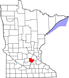 | |
| Townships | ||
| Unincorporated communities | ||
| Ghost town | ||
| Footnotes | ‡This populated place also has portions in an adjacent county or counties | |
Coordinates: 44°46′N 93°55′W / 44.767°N 93.917°W