Norton, Kansas
| Norton, Kansas | |
|---|---|
| City | |
|
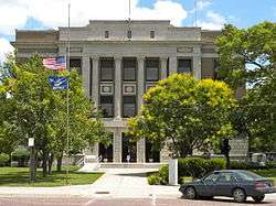
Norton County Courthouse (2010) | |
 Location within Norton County and Kansas | |
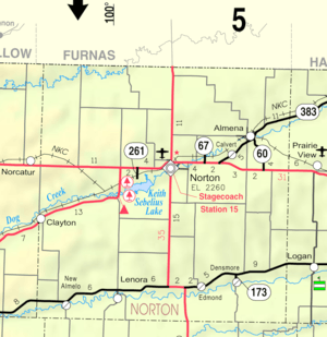 KDOT map of Norton County (legend) | |
| Coordinates: 39°50′0″N 99°53′27″W / 39.83333°N 99.89083°WCoordinates: 39°50′0″N 99°53′27″W / 39.83333°N 99.89083°W | |
| Country | United States |
| State | Kansas |
| County | Norton |
| Area[1] | |
| • Total | 1.93 sq mi (5.00 km2) |
| • Land | 1.93 sq mi (5.00 km2) |
| • Water | 0 sq mi (0 km2) |
| Elevation | 2,313 ft (705 m) |
| Population (2010)[2] | |
| • Total | 2,928 |
| • Estimate (2015)[3] | 2,841 |
| • Density | 1,500/sq mi (590/km2) |
| Time zone | Central (CST) (UTC-6) |
| • Summer (DST) | CDT (UTC-5) |
| ZIP code | 67654 |
| Area code(s) | 785 |
| FIPS code | 20-51500 [4] |
| GNIS feature ID | 0471901 [5] |
| Website | City Website |
Norton is a city in, and the county seat of, Norton County, Kansas, United States.[6] As of the 2010 census, the city population was 2,928.[7]
History
Norton was founded in 1872.[8] Like the county, it was named for Capt. Orloff Norton.[9]
The first hotel was a log house, built in 1873.[10]
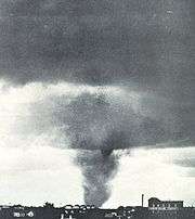
One of the first recorded tornado pictures was taken in Norton, in 1909 by photographer, Will Keller.
Geography
Norton is located at 39°50′0″N 99°53′27″W / 39.83333°N 99.89083°W (39.833338, -99.890899).[11] According to the United States Census Bureau, the city has a total area of 1.93 square miles (5.00 km2), all land.[1] The city is situated on the north side of Prairie Dog Creek in Norton County. Before the Bureau of Reclamation constructed Keith Sebelius Lake in 1963, Norton was prone to frequent flooding. The construction of the Dam has since resolved the problem and created the current reservoir that sits 2.5 miles (4.0 km) southwest of Norton.[12] The Nebraska border is located 11 miles (18 km) north of the city.
Demographics
| Historical population | |||
|---|---|---|---|
| Census | Pop. | %± | |
| 1880 | 634 | — | |
| 1890 | 1,074 | 69.4% | |
| 1900 | 1,202 | 11.9% | |
| 1910 | 1,787 | 48.7% | |
| 1920 | 2,186 | 22.3% | |
| 1930 | 2,767 | 26.6% | |
| 1940 | 2,762 | −0.2% | |
| 1950 | 3,060 | 10.8% | |
| 1960 | 3,345 | 9.3% | |
| 1970 | 3,627 | 8.4% | |
| 1980 | 3,400 | −6.3% | |
| 1990 | 3,017 | −11.3% | |
| 2000 | 3,012 | −0.2% | |
| 2010 | 2,928 | −2.8% | |
| Est. 2015 | 2,841 | [3] | −3.0% |
| U.S. Decennial Census | |||
2010 census
As of the census[2] of 2010, there were 2,928 people, 1,290 households, and 763 families residing in the city. The population density was 1,517.1 inhabitants per square mile (585.8/km2). There were 1,465 housing units at an average density of 759.1 per square mile (293.1/km2). The racial makeup of the city was 96.8% White, 0.2% African American, 0.1% Native American, 0.4% Asian, 0.5% from other races, and 1.9% from two or more races. Hispanic or Latino of any race were 3.3% of the population.
There were 1,290 households of which 26.3% had children under the age of 18 living with them, 46.5% were married couples living together, 9.3% had a female householder with no husband present, 3.3% had a male householder with no wife present, and 40.9% were non-families. 36.1% of all households were made up of individuals and 18.3% had someone living alone who was 65 years of age or older. The average household size was 2.20 and the average family size was 2.86.
The median age in the city was 44.8 years. 23.2% of residents were under the age of 18; 6.4% were between the ages of 18 and 24; 20.6% were from 25 to 44; 27.8% were from 45 to 64; and 22% were 65 years of age or older. The gender makeup of the city was 46.6% male and 53.4% female.
2000 census
As of the census[4] of 2000, there were 3,012 people, 1,331 households, and 814 families residing in the city. The population density was 1,566.5 people per square mile (605.7/km²). There were 1,517 housing units at an average density of 789.0 per square mile (305.1/km²). The racial makeup of the city was 97.91% White, 0.40% Native American, 0.33% Asian, 0.03% African American, 0.03% Pacific Islander, 0.63% from other races, and 0.66% from two or more races. Hispanic or Latino of any race were 2.03% of the population.
There were 1,331 households out of which 27.7% had children under the age of 18 living with them, 50.5% were married couples living together, 8.5% had a female householder with no husband present, and 38.8% were non-families. 36.1% of all households were made up of individuals and 20.7% had someone living alone who was 65 years of age or older. The average household size was 2.19 and the average family size was 2.86.
In the city the population was spread out with 24.5% under the age of 18, 5.3% from 18 to 24, 23.5% from 25 to 44, 22.1% from 45 to 64, and 24.6% who were 65 years of age or older. The median age was 43 years. For every 100 females there were 91.5 males. For every 100 females age 18 and over, there were 82.9 males.
The median income for a household in the city was $30,339, and the median income for a family was $36,179. Males had a median income of $25,943 versus $20,559 for females. The per capita income for the city was $16,438. About 5.5% of families and 9.5% of the population were below the poverty line, including 10.4% of those under age 18 and 6.5% of those age 65 or over.
Climate
Norton is on the boundary of two climate zones, humid continental and semiarid. Temperatures can fluctuate drastically between the winter and summer seasons with average lows of 15 °F in January to average highs of 94 °F in July. Precipitation is relatively low with an average yearly rainfall of 21.1 inches. Snowfall throughout the year averages 25.1 inches (640 mm), however, because of its location on the high plains, snowfall totals can sometimes approach the yearly average after a single snowfall.
| Climate data for Norton, Kansas | |||||||||||||
|---|---|---|---|---|---|---|---|---|---|---|---|---|---|
| Month | Jan | Feb | Mar | Apr | May | Jun | Jul | Aug | Sep | Oct | Nov | Dec | Year |
| Record high °F (°C) | 81 (27) |
81 (27) |
93 (34) |
100 (38) |
105 (41) |
114 (46) |
117 (47) |
115 (46) |
112 (44) |
101 (38) |
86 (30) |
83 (28) |
117 (47) |
| Average high °F (°C) | 42 (6) |
47 (8) |
55 (13) |
67 (19) |
76 (24) |
87 (31) |
94 (34) |
93 (34) |
86 (30) |
72 (22) |
56 (13) |
45 (7) |
68 (20) |
| Average low °F (°C) | 15 (−9) |
19 (−7) |
26 (−3) |
38 (3) |
49 (9) |
60 (16) |
65 (18) |
64 (18) |
54 (12) |
41 (5) |
27 (−3) |
19 (−7) |
40 (4) |
| Record low °F (°C) | −24 (−31) |
−23 (−31) |
−20 (−29) |
4 (−16) |
26 (−3) |
37 (3) |
44 (7) |
39 (4) |
19 (−7) |
8 (−13) |
−11 (−24) |
−19 (−28) |
−24 (−31) |
| Average precipitation inches (mm) | 0.4 (10) |
0.7 (18) |
1.2 (30) |
2.1 (53) |
3 (80) |
3.7 (94) |
2.7 (69) |
2.7 (69) |
1.0 (25) |
1.4 (36) |
0.8 (20) |
0.6 (15) |
21.1 (536) |
| Average snowfall inches (cm) | 4 (10) |
5.5 (14) |
7.2 (18.3) |
1.8 (4.6) |
0.1 (0.3) |
0 (0) |
0 (0) |
0 (0) |
0 (0) |
0.2 (0.5) |
2.6 (6.6) |
3.7 (9.4) |
25.1 (63.8) |
| Average rainy days | 1.5 | 2.2 | 3.4 | 4.9 | 6.1 | 6.5 | 5.3 | 5.2 | 3.5 | 2.7 | 2 | 1.8 | 45.1 |
| Source: Weatherbase [13] NOAA[14] | |||||||||||||
Education
The Board of Education for the Unified School District #211, the Norton Community Schools, oversees the operation of three student attendance centers in the Community of Norton.
Eisenhower Elementary School Constructed in 1954 and added on to in 1966 and 1990, Eisenhower Elementary serves students in USD 211 in grades ECD through sixth grade. Full day, every day kindergarten is offered as is a full range of special education services. Grades ECD through four are taught in self-contained classrooms. Grades 5 & 6 are departmentalized for instruction in math, reading, science, language arts and computer technology. Each teacher also teaches social studies and spelling to their homeroom students.
Norton Junior High School Constructed in 1937 and extensively remodeled in 1984, Norton Junior High School serves the 120+ students in grades 7 & 8. In addition to required classes of math, language arts, physical education/ health, science and social studies each junior high student receives 3 semesters of instruction in computer technology and digital media production and one semester of technology exploration (robotics, pneumatics, electronics, etc.). Elective classes are offered in vocal music, instrumental music, art, wood working, and family and consumer sciences.
Norton Community High School Constructed in 1975 & 1977, NCHS is a 3A high school with an enrollment of 200+. A comprehensive high school, NCHS is able to offer instruction in the areas of calculus, physics, human anatomy, chemistry II and foreign language. In addition to the regular academic curriculum, NCHS offers fine arts and vocational training.
The Norton Community High School Bluejays have won ten Kansas State High School Activities Association state championships in wrestling, including a state championship in 2010 and three consecutive Class 3-2-1A championships in 2004-6. Norton's football team won back-to-back Class 4A state championships in 1985 and 1986, and finished as state runners-up in 1989. The girls basketball and boys basketball teams won state championships in 1983 and 2003, respectively, and have made numerous state tournament appearances. NCHS also boasts programs in girls tennis, girls volleyball, boys golf, cross country, and track and field.
Notable people
- Nick Allen, baseball player
- Kathleen Sebelius, the Secretary of Health and Human Services since April 28, 2009[15] and a former governor of Kansas.
- Keith Sebelius, former member of the United States House of Representatives from Kansas from 1969 to 1981
- K. Gary Sebelius, US Magistrate Judge, son of Keith Sebelius, husband of Kathleen Sebelius
See also
References
- 1 2 "US Gazetteer files 2010". United States Census Bureau. Retrieved 2012-07-06.
- 1 2 "American FactFinder". United States Census Bureau. Retrieved 2012-07-06.
- 1 2 "Annual Estimates of the Resident Population for Incorporated Places: April 1, 2010 to July 1, 2015". Retrieved July 2, 2016.
- 1 2 "American FactFinder". United States Census Bureau. Retrieved 2008-01-31.
- ↑ "US Board on Geographic Names". United States Geological Survey. 2007-10-25. Retrieved 2008-01-31.
- ↑ "Find a County". National Association of Counties. Retrieved 2011-06-07.
- ↑ "2010 City Population and Housing Occupancy Status". U.S. Census Bureau. Retrieved March 27, 2011.
- ↑ Kansas State Historical Society (1916). Biennial Report of the Board of Directors of the Kansas State Historical Society. Kansas State Printing Plant. p. 253.
- ↑ "Profile for Norton, Kansas". ePodunk. Retrieved 21 June 2014.
- ↑ Blackmar, Frank Wilson (1912). Kansas: A Cyclopedia of State History, Volume 2. Standard Publishing Company. p. 374.
- ↑ "US Gazetteer files: 2010, 2000, and 1990". United States Census Bureau. 2011-02-12. Retrieved 2011-04-23.
- ↑ "Project Details - Almena Unit". United States Bureau of Reclamation. Retrieved 2010-11-02.
- ↑ "Historical Weather for Norton, KS". Weatherbase. Retrieved September 4, 2009.
- ↑ "Norton Climate Records". NOAA. Retrieved September 4, 2009.
- ↑ Goldstein, David; Klepper, David (2009-04-28). "Sebelius sworn in to Cabinet, Parkinson becomes Kansas governor". The Kansas City Star. Archived from the original on April 30, 2009. Retrieved 2009-04-29.
Further reading
- History of the State of Kansas; William G. Cutler; A.T. Andreas Publisher; 1883. (Online HTML eBook)
- Kansas : A Cyclopedia of State History, Embracing Events, Institutions, Industries, Counties, Cities, Towns, Prominent Persons, Etc; 3 Volumes; Frank W. Blackmar; Standard Publishing Co; 944 / 955 / 824 pages; 1912. (Volume1 - Download 54MB PDF eBook),(Volume2 - Download 53MB PDF eBook), (Volume3 - Download 33MB PDF eBook)
External links
| Wikimedia Commons has media related to Norton, Kansas. |
- City
- Norton - Directory of Public Officials
- Norton Area Chamber of Commerce
- Norton County
- Norton Facebook Group
- Schools
- USD 211, local school district
- Maps
- Norton City Map, KDOT
Municipalities and communities of Norton County, Kansas, United States | ||
|---|---|---|
| Cities | 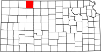 | |
| Unincorporated community | ||
| Footnotes | ‡This populated place also has portions in an adjacent county or counties | |