New Haven Township, Gallatin County, Illinois
| New Haven Township | |
|---|---|
| Township | |
|
Fields just south of New Haven | |
 Location in Gallatin County | |
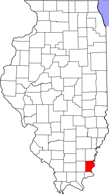 Gallatin County's location in Illinois | |
| Coordinates: 37°50′36″N 88°05′57″W / 37.84333°N 88.09917°WCoordinates: 37°50′36″N 88°05′57″W / 37.84333°N 88.09917°W | |
| Country | United States |
| State | Illinois |
| County | Gallatin |
| Established | November 5, 1890 |
| Area | |
| • Total | 45.56 sq mi (118.0 km2) |
| • Land | 43.73 sq mi (113.3 km2) |
| • Water | 1.84 sq mi (4.8 km2) 4.04% |
| Elevation | 335 ft (102 m) |
| Population (2010) | |
| • Total | 478 |
| • Density | 10.9/sq mi (4.2/km2) |
| Time zone | CST (UTC-6) |
| • Summer (DST) | CDT (UTC-5) |
| ZIP codes | 62867, 62871 62979, 62984 |
| GNIS feature ID | 0429436 |

New Haven Township is one of ten townships in Gallatin County, Illinois, USA. As of the 2010 census, its population was 478 and it contained 251 housing units.[1]
Geography
According to the 2010 census, the township has a total area of 45.56 square miles (118.0 km2), of which 43.73 square miles (113.3 km2) (or 95.98%) is land and 1.84 square miles (4.8 km2) (or 4.04%) is water.[1]
Within the township lies the Duffy Site, a Late Woodland Native American archaeological site located southeast of the village of New Haven.[2]
Cities, towns, villages
Major highways
Rivers
Lakes
- Hulda Lake
School districts
- Gallatin Community Unit School District 7
Political districts
- Illinois' 15th congressional district
- State House District 118
- State Senate District 59
References
- "New Haven Township, Gallatin County, Illinois". Geographic Names Information System. United States Geological Survey. Retrieved 2010-01-17.
- United States Census Bureau 2007 TIGER/Line Shapefiles
- United States National Atlas
- 1 2 "Population, Housing Units, Area, and Density: 2010 - County -- County Subdivision and Place -- 2010 Census Summary File 1". United States Census. Retrieved 2013-05-28.
- ↑ Winters, Howard D. An Archaeological Survey of the Wabash Valley in Illinois. Springfield: Illinois State Museum Society, 1963, 82.
External links
 |
Asbury Township Heralds Prairie Township, White County |
Emma Township, White County | | |
| Ridgway Township | |
Point Township, Posey County, Indiana Uniontown Township, Union County, Kentucky | ||
| ||||
| | ||||
| Gold Hill Township | Shawnee Township |
Municipalities and communities of Gallatin County, Illinois, United States | ||
|---|---|---|
| City | ||
| Villages | ||
| Townships | ||
| Unincorporated communities | ||
This article is issued from Wikipedia - version of the 12/4/2013. The text is available under the Creative Commons Attribution/Share Alike but additional terms may apply for the media files.