New Hampshire Route 118
| ||||
|---|---|---|---|---|
|
Map of Grafton County in northwestern New Hampshire with NH 118 highlighted in red | ||||
| Route information | ||||
| Maintained by NHDOT | ||||
| Length: | 37.003 mi[1] (59.551 km) | |||
| Major junctions | ||||
| South end: |
| |||
| North end: |
| |||
| Location | ||||
| Counties: | Grafton | |||
| Highway system | ||||
| ||||

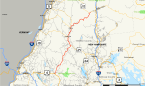
New Hampshire Route 118 (abbreviated NH 118) is a 37.003-mile-long (59.551 km) secondary north–south highway in Grafton County, New Hampshire. NH 118 stretches from Woodstock in the White Mountains Region south to Canaan in the Upper Valley region.
The northern terminus of NH 118 is at New Hampshire Route 112 (the Lost River Road) in Woodstock. The road runs southward through the towns of Warren, Wentworth, Rumney, and Dorchester. The southern terminus of NH 118 is at U.S. Route 4 in Canaan. From Canaan to Wentworth, the highway is named Dorchester Road. The section from Warren to the Lost River is known as the Sawyer Highway.
Major intersections
The entire route is in Grafton County. [1][2]
| Location[1][2] | mi[1][2] | km | Destinations | Notes | |
|---|---|---|---|---|---|
| Canaan | 0.000 | 0.000 | Southern terminus of NH 118 | ||
| Rumney | 15.035 | 24.196 | Southern end of concurrency with NH 25 | ||
| Wentworth | 19.250 | 30.980 | Eastern terminus of NH 25A | ||
| Warren | 23.095 | 37.168 | Eastern terminus of NH 25C | ||
| 23.994 | 38.615 | Northern end of concurrency with NH 25 | |||
| Woodstock | 37.003 | 59.551 | Northern terminus | ||
1.000 mi = 1.609 km; 1.000 km = 0.621 mi
| |||||
References
- 1 2 3 4 Bureau of Planning & Community Assistance (February 20, 2015). "NH Public Roads". Concord, New Hampshire: New Hampshire Department of Transportation. Retrieved April 7, 2015.
- 1 2 3 Bureau of Planning & Community Assistance (April 3, 2015). "Nodal Reference 2015, State of New Hampshire". New Hampshire Department of Transportation. Retrieved April 7, 2015.
External links
This article is issued from Wikipedia - version of the 4/18/2015. The text is available under the Creative Commons Attribution/Share Alike but additional terms may apply for the media files.