New England Traverse
| New England Traverse | |
|---|---|
|
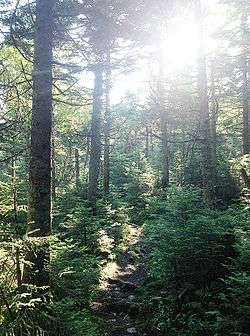
Sub-Alpine Boreal Forest along the New England Traverse | |
| Length | 534 mi (859 km) |
| Location | New Jersey / New York / Connecticut / Massachusetts / Vermont |
| Trailheads |
Fort Lee, New Jersey North Troy, Vermont |
| Use | Hiking, Snowshoeing |
| Elevation | |
| Highest point | Mount Mansfield 4,393 ft (1,339 m) |
| Lowest point | Bear Mountain Bridge 124 ft (38 m) |
| Hiking details | |
| Trail difficulty | Moderate to strenuous |
The New England Traverse is a wilderness footpath traveling from Manhattan to Canada. The route is 534 miles (859 km) long and uses three designated hiking trails, spanning five states, three geographic regions and three unique biomes, producing over 500,000 acres (200,000 ha) of conserved public land.
Making use of the Long Path, the Appalachian Trail and the Long Trail, the route traverses the Hudson Highlands, the Berkshires and the Green Mountains regions, while traveling through eastern woodland, sub-alpine boreal forest and alpine tundra biomes. Some notable conserved lands that are crossed include the Palisades Interstate Park, Bear Mountain State Park, Mount Greylock State Reservation, Mount Mansfield State Forest, Camel's Hump State Forest, and the Green Mountain National Forest. The trail sections used by the traverse are maintained by the New York–New Jersey Trail Conference, the Appalachian Mountain Club, the Appalachian Trail Conservancy and the Green Mountain Club.
Route
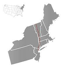
The route follows the first section of the Long Path outside of New York City, where it follows the Palisades to the Hudson Highlands and joins the Appalachian Trail. The New England Traverse then follows the Appalachian Trail through the Berkshires to the Green Mountains where it joins the Long Trail north to the Canada–US border.
History
Originally presented by long-distance hiker John Fox as a solution to the need for a trail across the region and to gain awareness for the value of the natural environments near the urban metropolises of the northeastern United States. The trail was not meant to serve as a proposal for official designation but instead to offer inspiration for the completion of similar trails in the region.
See also
References
- "New England Traverse: Discovering a Wilderness Route", Backpacking Light, 2013
- Fox, John (Winter–Spring 2014). "Environmental Factors Effecting a Traverse of New England". Appalachian Magazine.
External links
- New York-New Jersey Trail Conference
- Appalachian Trail Conservancy
- Appalachian Mountain Club
- Green Mountain Club