New Concord, Ohio
| New Concord, Ohio | |
|---|---|
| Village | |
|
| |
 Location of New Concord, Ohio | |
 Location of New Concord in Muskingum County | |
| Coordinates: 39°59′40″N 81°44′11″W / 39.99444°N 81.73639°WCoordinates: 39°59′40″N 81°44′11″W / 39.99444°N 81.73639°W | |
| Country | United States |
| State | Ohio |
| County | Muskingum |
| Townships | Highland, Union |
| Area[1] | |
| • Total | 1.63 sq mi (4.22 km2) |
| • Land | 1.63 sq mi (4.22 km2) |
| • Water | 0 sq mi (0 km2) |
| Elevation[2] | 863 ft (263 m) |
| Population (2010)[3] | |
| • Total | 2,491 |
| • Estimate (2012[4]) | 2,490 |
| • Density | 1,528.2/sq mi (590.0/km2) |
| Time zone | Eastern (EST) (UTC-5) |
| • Summer (DST) | EDT (UTC-4) |
| ZIP code | 43762 |
| Area code(s) | 740 |
| FIPS code | 39-54446[5] |
| GNIS feature ID | 1065115[2] |
New Concord is a village in Muskingum County, Ohio, United States. The population is 2,491 as of the 2010 census. New Concord is the home of Muskingum University and is served by a branch of the Muskingum County Library System.
History
New Concord was laid out in 1828 when the National Road was extended to that point.[6] In 1837, almost ten years later, Muskingum University was founded with its first class graduating in 1839.[7] A post office named New Concord has been in operation since 1832.[8] As U.S. Route 40 was a large connector for trade, New Concord became a stopping place for those who came through until bypassed by Interstate 70 in the 1960s and 1970s.[7][9]
Geography
New Concord is located at 39°59′40″N 81°44′11″W / 39.994389°N 81.736412°W.[10]
According to the United States Census Bureau, the village has a total area of 1.63 square miles (4.22 km2), all land.[1]
New Concord is located on U.S. Route 40, the old National Road, and just off the newer Interstate 70 which parallels it.
Demographics
| Historical population | |||
|---|---|---|---|
| Census | Pop. | %± | |
| 1850 | 337 | — | |
| 1860 | 474 | 40.7% | |
| 1870 | 488 | 3.0% | |
| 1880 | 514 | 5.3% | |
| 1890 | 719 | 39.9% | |
| 1900 | 675 | −6.1% | |
| 1910 | 683 | 1.2% | |
| 1920 | 889 | 30.2% | |
| 1930 | 1,087 | 22.3% | |
| 1940 | 1,067 | −1.8% | |
| 1950 | 1,797 | 68.4% | |
| 1960 | 2,127 | 18.4% | |
| 1970 | 2,318 | 9.0% | |
| 1980 | 1,860 | −19.8% | |
| 1990 | 2,086 | 12.2% | |
| 2000 | 2,651 | 27.1% | |
| 2010 | 2,491 | −6.0% | |
| Est. 2015 | 2,343 | [11] | −5.9% |
2000 census
As of the census[5] of 2000, there were 2,651 people, 672 households, and 376 families residing in the village. The population density was 1,771.0 people per square mile (682.4/km2). There were 709 housing units at an average density of 473.6 per square mile (182.5/km2). The racial makeup of the village was 96.15% White, 1.43% African American, 0.11% Native American, 1.66% Asian, 0.08% from other races, and 0.57% from two or more races. Hispanic or Latino of any race were 0.91% of the population.
There were 672 households out of which 26.8% had children under the age of 18 living with them, 44.5% were married couples living together, 9.7% had a female householder with no husband present, and 44.0% were non-families. 36.3% of all households were made up of individuals and 15.5% had someone living alone who was 65 years of age or older. The average household size was 2.24 and the average family size was 2.93.
In the village, the population was spread out with 12.7% under the age of 18, 48.5% from 18 to 24, 13.6% from 25 to 44, 12.8% from 45 to 64, and 12.4% who were 65 years of age or older. The median age was 22 years. For every 100 females there were 85.1 males. For every 100 females age 18 and over, there were 85.3 males.
The median income for a household in the village was $27,011, and the median income for a family was $43,333. Males had a median income of $34,750 versus $25,583 for females. The per capita income for the village was $17,973. About 16.1% of families and 24.6% of the population were below the poverty line, including 29.2% of those under age 18 and 13.5% of those aged 65 or over.
2010 census
As of the census[3] of 2010, there were 2,491 people, 670 households, and 366 families residing in the village. The population density was 1,528.2 inhabitants per square mile (590.0/km2). There were 745 housing units at an average density of 457.1 per square mile (176.5/km2). The racial makeup of the village was 96.1% White, 1.2% African American, 0.1% Native American, 1.0% Asian, 0.4% from other races, and 1.1% from two or more races. Hispanic or Latino of any race were 1.0% of the population.
There were 670 households of which 25.7% had children under the age of 18 living with them, 38.8% were married couples living together, 10.1% had a female householder with no husband present, 5.7% had a male householder with no wife present, and 45.4% were non-families. 33.7% of all households were made up of individuals and 14.2% had someone living alone who was 65 years of age or older. The average household size was 2.27 and the average family size was 2.78.
The median age in the village was 22.5 years. 12% of residents were under the age of 18; 46.6% were between the ages of 18 and 24; 14% were from 25 to 44; 14.6% were from 45 to 64; and 13% were 65 years of age or older. The gender makeup of the village was 45.2% male and 54.8% female.
Notable people
- John Glenn - former United States Senator, and the first American to orbit the Earth[13]
- William Rainey Harper - founder and first president of the University of Chicago
- David W. Stewart - United States Senator from Iowa
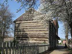
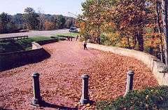
Places of interest
References
- 1 2 "US Gazetteer files 2010". United States Census Bureau. Retrieved 2013-01-06.
- 1 2 "US Board on Geographic Names". United States Geological Survey. 2007-10-25. Retrieved 2008-01-31.
- 1 2 "American FactFinder". United States Census Bureau. Retrieved 2013-01-06.
- ↑ "Population Estimates". United States Census Bureau. Retrieved 2013-06-17.
- 1 2 "American FactFinder". United States Census Bureau. Retrieved 2008-01-31.
- ↑ Everhart, F.J. (1882). 1794. History of Muskingum County, Ohio, with illustrations and biographical sketches of prominent men and pioneers. F.J. Everhart & Co. p. 418.
- 1 2 "A Brief History | Village of New Concord, Ohio". www.newconcord-oh.gov. Retrieved 2016-11-10.
- ↑ "Muskingum County". Jim Forte Postal History. Retrieved 5 January 2016.
- ↑ "Interstate-Guide: Interstate 70". Retrieved 2016-11-10.
- ↑ "US Gazetteer files: 2010, 2000, and 1990". United States Census Bureau. 2011-02-12. Retrieved 2011-04-23.
- ↑ "Annual Estimates of the Resident Population for Incorporated Places: April 1, 2010 to July 1, 2015". Retrieved July 2, 2016.
- ↑ "Census of Population and Housing". Census.gov. Retrieved June 4, 2015.
- ↑ Kupperberg, Paul (1 November 2003). John Glenn: The First American in Orbit and His Return to Space. The Rosen Publishing Group. p. 15. ISBN 978-0-8239-4460-6.
External links
Municipalities and communities of Muskingum County, Ohio, United States | ||
|---|---|---|
| City | 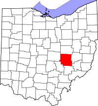 | |
| Villages | ||
| Townships | ||
| CDPs | ||
| Unincorporated communities |
| |
| Footnotes | ‡This populated place also has portions in an adjacent county or counties | |