Jackson Township, Muskingum County, Ohio
| Jackson Township, Muskingum County, Ohio | |
|---|---|
| Township | |
|
Countryside north of Frazeysburg | |
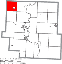 Location of Jackson Township in Muskingum County | |
| Coordinates: 40°7′26″N 82°7′52″W / 40.12389°N 82.13111°WCoordinates: 40°7′26″N 82°7′52″W / 40.12389°N 82.13111°W | |
| Country | United States |
| State | Ohio |
| County | Muskingum |
| Area | |
| • Total | 24.4 sq mi (63.3 km2) |
| • Land | 24.4 sq mi (63.2 km2) |
| • Water | 0.0 sq mi (0.0 km2) |
| Elevation[1] | 719 ft (219 m) |
| Population (2000) | |
| • Total | 2,221 |
| • Density | 91.0/sq mi (35.1/km2) |
| Time zone | Eastern (EST) (UTC-5) |
| • Summer (DST) | EDT (UTC-4) |
| FIPS code | 39-37926[2] |
| GNIS feature ID | 1086722[1] |

Jackson Township is one of the twenty-five townships of Muskingum County, Ohio, United States. The 2000 census found 2,221 people in the township, 1,020 of whom lived in the unincorporated portions of the township.[3]
Geography
Located in the northwestern corner of the county, it borders the following townships:
- Pike Township, Coshocton County - north
- Washington Township, Coshocton County - northeast corner
- Cass Township - east
- Licking Township - south
- Hanover Township, Licking County - southwest corner
- Perry Township, Licking County - west
The village of Frazeysburg is located in central Jackson Township.
Name and history
Established in 1815, Jackson Township most likely was named after General Andrew Jackson, afterward President of the United States.[4] It is one of thirty-seven Jackson Townships statewide.[5]
By the 1830s, Jackson Township had two gristmills and three saw mills.[6]
Government
The township is governed by a three-member board of trustees, who are elected in November of odd-numbered years to a four-year term beginning on the following January 1. Two are elected in the year after the presidential election and one is elected in the year before it. There is also an elected township fiscal officer,[7] who serves a four-year term beginning on April 1 of the year after the election, which is held in November of the year before the presidential election. Vacancies in the fiscal officership or on the board of trustees are filled by the remaining trustees.
References
- 1 2 "US Board on Geographic Names". United States Geological Survey. 2007-10-25. Retrieved 2008-01-31.
- ↑ "American FactFinder". United States Census Bureau. Archived from the original on September 11, 2013. Retrieved 2008-01-31.
- ↑ Muskingum County, Ohio — Population by Places Estimates Ohio State University, 2007. Accessed 15 May 2007.
- ↑ Everhart, F.J. (1882). 1794. History of Muskingum County, Ohio, with illustrations and biographical sketches of prominent men and pioneers. F.J. Everhart & Co. p. 476.
- ↑ "Detailed map of Ohio" (PDF). United States Census Bureau. 2000. Retrieved 2007-02-16.
- ↑ Kilbourn, John (1833). "The Ohio Gazetteer, or, a Topographical Dictionary". Scott and Wright. p. 250. Retrieved 12 December 2013.
- ↑ §503.24, §505.01, and §507.01 of the Ohio Revised Code. Accessed 4/30/2009.
External links
Municipalities and communities of Muskingum County, Ohio, United States | ||
|---|---|---|
| City | 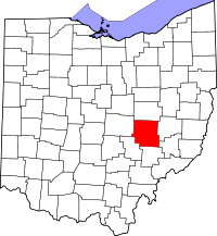 | |
| Villages | ||
| Townships | ||
| CDPs | ||
| Unincorporated communities |
| |
| Footnotes | ‡This populated place also has portions in an adjacent county or counties | |