Nelson, Georgia
| Nelson, Georgia | |
|---|---|
| City | |
|
Nelson city hall | |
 Location in Pickens County and the state of Georgia | |
| Coordinates: 34°22′54″N 84°22′17″W / 34.38167°N 84.37139°WCoordinates: 34°22′54″N 84°22′17″W / 34.38167°N 84.37139°W | |
| Country | United States |
| State | Georgia |
| Counties | Pickens, Cherokee |
| Area | |
| • Total | 1.46 sq mi (3.77 km2) |
| • Land | 1.45 sq mi (3.75 km2) |
| • Water | 0.008 sq mi (0.02 km2) |
| Elevation | 1,237 ft (377 m) |
| Population (2010) | |
| • Total | 1,314 |
| • Density | 907/sq mi (350.3/km2) |
| Time zone | Eastern (EST) (UTC-5) |
| • Summer (DST) | EDT (UTC-4) |
| ZIP code | 30151 |
| Area code(s) | 770 |
| FIPS code | 13-54572[1] |
| GNIS feature ID | 0319244[2] |

Nelson is a city in Pickens and Cherokee counties in the U.S. state of Georgia. As of the 2010 census, the city had a total population of 1,314.[3] It is part of the Atlanta metropolitan area.
History
The city is named for John Nelson, an early landowner, farmer, and rifle maker.[4]
A railroad line built in 1883 from Atlanta, through the valleys and mountain passes of Cherokee County to Nelson and Tate, made possible the development of large marble quarries. One of the largest marble veins in the world is in Pickens County, running at least 4 miles (6 km) long. It is a half-mile deep and almost that wide in places. Over 60 percent of the monuments in Washington, D.C. are made from Pickens County marble.
The Marble Museum is located in the Nelson City Hall and features a year-round exhibit that includes "examples of fine marble and shows the history of marble mining in Pickens County". Many stone cutters and other workers who migrated from either Italy or Scotland in the early years of the industry settled in Nelson to work in the area's marble industry. Today the Georgia Northeastern Railroad operates between Tate, Georgia, and the CSX interchange at Elizabeth (Marietta) five days a week. The Georgia Marble rail lines at Tate and Marble Hill, and the Blue Ridge Scenic Railroad at Blue Ridge, Georgia are also operated by GNRR. Their website also states the "GNRR runs through a Georgia Marble facility that no is no longer served by rail" at Nelson.
On April 1, 2013, the city council voted unanimously to approve the "Family Protection Ordinance". Every head of household must own a gun and ammunition to "provide for the emergency management of the city" and to "provide for and protect the safety, security and general welfare of the city and its inhabitants." No one is required to buy one if they don't have one and the ordinance doesn't penalize anyone who does not comply. Convicted felons are exempt.[5]
Geography
Nelson is located on the border of Pickens and Cherokee counties at 34°22′54″N 84°22′17″W / 34.38167°N 84.37139°W (34.381562, -84.371303).[6] The original city center is located in Pickens County, but the city limits have recently expanded southward so that more of the city is now located in Cherokee County.
According to the United States Census Bureau, the city has a total area of 1.5 square miles (3.8 km2), of which 0.008 square miles (0.02 km2), or 0.56%, is water.[3]
Nelson is served through its downtown by the Georgia Northeastern Railroad, and by Canton Road, the town's main street and the former route of Georgia State Route 5. South on old 5 is Ball Ground, and north is Tate. The north end of Interstate 575 and south end of State Route 515 is at the county line just to the west of Nelson. I-575 leads south 52 miles (84 km) to Atlanta, and SR 515 leads north 26 miles (42 km) to Ellijay.
Demographics
| Historical population | |||
|---|---|---|---|
| Census | Pop. | %± | |
| 1890 | 266 | — | |
| 1900 | 254 | −4.5% | |
| 1910 | 550 | 116.5% | |
| 1920 | 511 | −7.1% | |
| 1930 | 798 | 56.2% | |
| 1940 | 679 | −14.9% | |
| 1950 | 645 | −5.0% | |
| 1960 | 658 | 2.0% | |
| 1970 | 613 | −6.8% | |
| 1980 | 562 | −8.3% | |
| 1990 | 486 | −13.5% | |
| 2000 | 626 | 28.8% | |
| 2010 | 1,314 | 109.9% | |
| Est. 2015 | 1,347 | [7] | 2.5% |
As of the census[1] of 2000, there were 626 people, 254 households, and 188 families residing in the city. The population density was 695.0 people per square mile (268.6/km²). There were 275 housing units at an average density of 305.3 per square mile (118.0/km²). The racial makeup of the city was 89.94% White, 9.42% African American, 0.16% Native American, 0.16% Asian, and 0.32% from two or more races. Hispanic or Latino of any race were 0.16% of the population.
There were 254 households out of which 27.2% had children under the age of 18 living with them, 64.2% were married couples living together, 8.3% had a female householder with no husband present, and 25.6% were non-families. 22.4% of all households were made up of individuals and 10.6% had someone living alone who was 65 years of age or older. The average household size was 2.46 and the average family size was 2.88.
In the city the population was spread out with 19.3% under the age of 18, 7.7% from 18 to 24, 28.9% from 25 to 44, 27.2% from 45 to 64, and 16.9% who were 65 years of age or older. The median age was 42 years. For every 100 females there were 93.2 males. For every 100 females age 18 and over, there were 90.6 males.
The median income for a household in the city was $44,250, and the median income for a family was $51,806. Males had a median income of $35,066 versus $30,450 for females. The per capita income for the city was $20,604. About 1.1% of families and 3.7% of the population were below the poverty line, including 1.1% of those under age 18 and 8.5% of those age 65 or over.
The estimated median household income in 2008 was $56,361, compared to $50,861 for the state of Georgia. The estimated per capita income in 2008 was $26,140.
The estimated median house or condo value in 2008 was $208,186, compared to $169,100 for the state of Georgia. The estimated median home value in Nelson was $110,800 in 2000. In 2008, the mean price for all housing units was $204,682, for detached houses $212,211, for townhouses or other attached units $147,212, and for mobile homes $54,519.
Notable people
- Claude Akins, actor
References
- 1 2 "American FactFinder". United States Census Bureau. Retrieved 2008-01-31.
- ↑ "US Board on Geographic Names". United States Geological Survey. 2007-10-25. Retrieved 2008-01-31.
- 1 2 "Geographic Identifiers: 2010 Demographic Profile Data (G001): Nelson city, Georgia". U.S. Census Bureau, American Factfinder. Retrieved July 24, 2014.
- ↑ U.S. Geological Survey Geographic Names Information System: Nelson, Georgia
- ↑ "GA. City Council Votes to Require Gun Ownership". AP. Retrieved 2 April 2013.
- ↑ "US Gazetteer files: 2010, 2000, and 1990". United States Census Bureau. 2011-02-12. Retrieved 2011-04-23.
- ↑ "Annual Estimates of the Resident Population for Incorporated Places: April 1, 2010 to July 1, 2015". Retrieved July 2, 2016.
- ↑ "Census of Population and Housing". Census.gov. Retrieved June 4, 2015.
Municipalities and communities of Cherokee County, Georgia, United States | ||
|---|---|---|
| Cities | 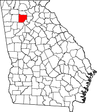 | |
| Unincorporated communities | ||
| Footnotes | ‡This populated place also has portions in an adjacent county or counties | |
Municipalities and communities of Pickens County, Georgia, United States | ||
|---|---|---|
| Cities |  | |
| Town | ||
| Unincorporated communities | ||
| Footnotes | ‡This populated place also has portions in an adjacent county or counties | |