Nelligen, New South Wales
| Nelligen New South Wales | |
|---|---|
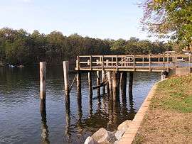 Wharf at Nelligen on the Clyde River | |
|
Nelligen | |
| Coordinates | 35°38′51″S 150°08′29″E / 35.64750°S 150.14139°ECoordinates: 35°38′51″S 150°08′29″E / 35.64750°S 150.14139°E |
| Population | 228 (2006 census)[1] |
| Postcode(s) | 2536 |
| Elevation | 0 m (0 ft) |
| Location |
|
| LGA(s) | Eurobodalla Shire |
| State electorate(s) | Bega |
| Federal Division(s) | Eden-Monaro |
Nelligen is a village on the Clyde River on the South Coast of New South Wales, Australia. It is located on the Kings Highway.
Location and services
The village is situated on the western bank of the River near a junction with Nelligen Creek,[2] and 8 km (5 mi) inland from Batemans Bay.
Local services include a general store, hotel, and general cemetery.[3][4][5]
History

The original inhabitants of the land were Aborigines of the Walbanga, Murrinjari and Bergalia clans.[5] The origin of the name is unclear and was already in use at the time of the first survey in 1828. The surveyor Robert Hoddle described the site of the future township as 640 acres (2.6 km2) of "good forest land at Nellican Creek"[5] and by the 1830s timber cutters had cleared a site for settlement and work had begun on a road to Batemans Bay.
The village of Nelligen was gazetted in 1854 and a road inland to Braidwood was completed two years later. No bridges existed across the Clyde at the time, so produce and minerals from southern New South Wales were delivered to Nelligen for transport by twice-weekly steamer to Sydney; the town was serviced by the Illawarra Steam Navigation Company. The post office opened in 1858 and a Protestant church was constructed in 1872.[5] The existing Roman Catholic church dates from 1895.[5]
By 1892 the population had grown to 500 but construction of several coastal bridges and the growth of Batemans Bay began to reduce local trading opportunities. By 1934 the population had fallen to 350,[5] and by 2006 this had further declined to 228.[1]
Between about 1860 and 1915 there were some gold workings in the Nelligen district.[6]
A punt service across the Clyde River was begun at Nelligen in 1895 and continued until 1964 when the Nelligen bridge was completed.[7]
Gallery

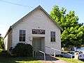 Mechanics' Institute at Nelligen, New South Wales built 1903
References
| Wikimedia Commons has media related to Nelligen, New South Wales. |
- 1 2 Australian Bureau of Statistics (25 October 2007). "Nelligen (State Suburb)". 2006 Census QuickStats. Retrieved 2008-01-12.
- ↑ "Nelligen Creek". Geographical Names Register (GNR) of NSW. Geographical Names Board of New South Wales. Retrieved 12 January 2008.
- ↑ "Nelligen South Coast NSW Australia Tourist Information". Clyde River Houseboats. January 2008. Retrieved 2008-01-12.
- ↑ "Nelligen on the Clyde". TravelSouth. January 2008. Retrieved 2008-01-12.
- 1 2 3 4 5 6 "Nelligen". The Age Newspaper. 2004-02-08. Retrieved 2008-01-12.
- ↑ Moore, Dennis. "The Forgotten Gold Mines of Nelligen". Welcome to the Clyde Coast. www.clydecoast.com.au. Archived from the original on 2007-08-29. Retrieved 2008-01-14.
- ↑ "Brief history of Nelligen, Batemans Bay and the Clyde River on the Eurobodalla South Coast, NSW Australia". Clyde River Houseboats. Retrieved 2008-01-14.
| Cities | |
|---|---|
| Townships |
|
| Local government areas | |
| National parks |
|
| Rivers and other waterbodies | |