Neighborhoods in Boston

Boston's diverse neighborhoods serve as a political and cultural organizing mechanism. The City of Boston's Office of Neighborhood Services has designated 23 Neighborhoods in the city:
- Allston
- Back Bay
- Bay Village
- Beacon Hill
- Brighton
- Charlestown
- Chinatown/Leather District
- Dorchester (divided for planning purposes into Mid Dorchester and Dorchester)
- Downtown
- East Boston
- Fenway Kenmore
- Hyde Park
- Jamaica Plain
- Mattapan
- Mission Hill
- North End
- Roslindale
- Roxbury
- South Boston
- South End
- West End
- West Roxbury
The islands in Boston Harbor are administered as part of the Boston Harbor Islands National Recreation Area.[1]
The Boston Redevelopment Authority,[2] the City Parking Clerk,[3] and the City's Department of Neighborhood Development[4] have also designated their own neighborhoods. Unofficially, Boston has many overlapping neighborhoods of various sizes. Neighborhood associations have formed around smaller communities or commercial districts (often with "Square" in the name) that have a well-defined center but poorly identified extremities.
History of Boston's neighborhoods
As the city of Boston has grown and evolved, its neighborhoods have changed as well. The names of the West End, North End, and South End refer to their positions on the Shawmut Peninsula, the original extent of Boston. Due to the annexation of surrounding communities, those neighborhoods are no longer at those geographic extremities.[5][6] The Back Bay and Bay Village neighborhoods were formerly part of an actual bay, becoming the neighborhoods they are today after landfill projects expanded the size of the city. Brighton (including Allston), Charlestown, Dorchester (including South Boston, Mid Dorchester, Mattapan, and Hyde Park), Roxbury (including West Roxbury, Roslindale and Jamaica Plain), have all at some point been municipalities independent from downtown Boston, providing a source of well-defined boundaries for the largest areas.
Geographic overview
Downtown Boston includes Downtown Crossing, the Financial District, and Government Center.
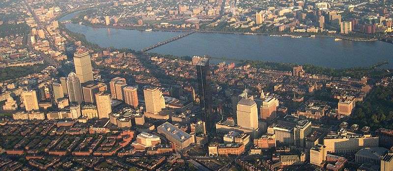
Surrounding downtown are the neighborhoods of Chinatown/Leather District, South End, North End, West End, Bay Village, Beacon Hill, and Back Bay. Chinatown/Leather District is the historical garment district and today has thriving Chinese and other Asian populations.[7] The South End is the center of the city's LGBT population and also populated by artists and young professionals as well as a vibrant African American community.[8] The North End retains an Italian flavor with its many Italian restaurants, though many of its Italian families have moved out, while young professionals have moved in.[9] The Back Bay, west of the Public Garden and Beacon Hill, a wealthy neighborhood,[10] is the site of the Massachusetts State House. The Back Bay and Beacon Hill are also home to national and local politicians, famous authors, and top business leaders and professionals. Bay Village is one of the smallest neighborhoods in Boston and mostly contains Greek Revival-style row houses.[11]
North and east of downtown are the neighborhoods of East Boston and Charlestown. East Boston has a majority of Hispanic and Brazilian population with a remnant of older Italians. On the north bank of the Charles River is Charlestown; once a predominantly Irish enclave and site of the Bunker Hill Monument, it is now a haven for young professionals.[12][13]
West of downtown are the neighborhoods of Fenway Kenmore, Allston, Brighton and Mission Hill. Fenway Kenmore borders the campus of Boston University and houses many college students and young professionals and is the location of Fenway Park. Allston and Brighton are populated heavily by students from nearby universities, as well as recent graduates. Mission Hill is adjacent to the Longwood Medical district, full of world-class medical institutions and retains an extremely diverse mix of African Americans, Asian Americans, whites and Latinos.
South of downtown are the neighborhoods of Roxbury, Jamaica Plain, Dorchester, Mid Dorchester, and South Boston. Dorchester, including Mid Dorchester, is Boston's largest neighborhood and predominantly a working class community considered to be Boston's most diverse. Roxbury is populated largely by African Americans, Caribbean Americans, and Latinos and is historically the center of Boston's black community. Jamaica Plain is a community of white professionals and Latinos, and includes the larger side of the Arnold Arboretum. South Boston is a predominantly Irish-American neighborhood, which hosts the city's annual St. Patrick's Day parade.[14]
South of Roxbury, Jamaica Plain, and Dorchester are the neighborhoods of Mattapan, Roslindale, Hyde Park, and West Roxbury. Roslindale is known for its small business district and includes the smaller side of the Arnold Arboretum. Roslindale has also recently become a majority-minority neighborhood. Mattapan remains the neighborhood with Boston's highest concentrations of African Americans. Hyde Park and West Roxbury have a distinct suburban feel, while still being a part of the city of Boston. Both neighborhoods have large areas of wooded parks and recreation land. Hyde Park is populated largely by African Americans and Caribbean Americans, whereas West Roxbury is predominantly white with rapidly growing African American and Latino populations.[15][16][17]
List of places and squares within neighborhood areas
The 23 official neighborhoods in Boston are made up of approximately 84 sub-districts, squares, and neighborhoods within each official neighborhood.The Boston Redevelopment Authority defines 16 planning districts (plus the Boston Harbor Islands) and 64 Neighborhood Statistical Areas (with four areas further subdivided). These correspond roughly with the neighborhoods and sub-neighborhoods of Boston. Unofficially, Boston is made up of approximately 105 neighborhoods.
- Allston and Brighton
- Allston Village
- Brighton Center
- Chestnut Hill
- Cleveland Circle
- Harvard Stadium/Charlesview
- Union Square
- Oak Square
- Faneuil Square
- Brighton Mills
- Lower Allston
- North Brighton
- Packard's Corner
- Soldier's Field
- Back Bay

- Bay Village (also known as South Cove)
- Beacon Hill
- Charlestown
- Bunker Hill
- The Neck
- The Navy Yard[18]
- Hayes Square
- City Square
- Thompson Square
- Sullivan Square[19]
- Chinatown and the Leather District
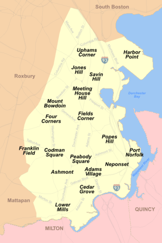
- Dorchester[20]
- Adams Corner/Adams Village
- Ashmont (including Ashmont Hill, Ashmont-Adams, and Peabody Square)
- Columbia Point/Harbor Point
- Cedar Grove
- Fields Corner
- Franklin Field
- Grove Hall
- Lower Mills
- Jones Hill
- Meeting House Hill
- Neponset
- Polish Triangle
- Popes Hill
- Port Norfolk
- Savin Hill
- Uphams Corner
- Downtown Boston and the Financial District
- Bulfinch Triangle
- Combat Zone (defunct)
- Downtown Crossing/Ladder District
- Fort Hill Square
- Government Center
- Haymarket Square (Boston)
- Post Office Square
- South Station
- Boston Theater District
- Waterfront
 Christopher Columbus Park in Downtown Waterfront
- East Boston
- Fenway/Kenmore
- Audubon Circle
- Back Bay Fens
- Kenmore Square
- Boston University (extends into Allston)
- Longwood Medical Area (extends into Mission Hill)
- Lansdowne Street/Fenway Park
- Hyde Park
- Readville
- Fairmount Hill
- Sunnyside

- Jamaica Plain
- Hyde Square
- Forest Hills/Woodbourne
- Moss Hill
- Mattapan
- Wellington Hill
- Mid Dorchester[21]
- Bowdoin-Geneva
- Codman Square
- Four Corners[22]
- Mission Hill
- Brigham Circle
- Back of the Hill
- Parker Hill
- North End
- Ann Street (North Street)
- Hanover Street

- Roslindale
- Roslindale Square
- Roxbury
- Dudley Square
- Egleston Square[23]
- Fort Hill
- Franklin Park (extends into Jamaica Plain and Dorchester)
- Roxbury Crossing
- South Boston
- Andrew Square (extends into Dorchester)
- D Street
- Fort Point
- South Boston Waterfront/Seaport District[24]
- City Point[25]
- South End
- West End
- Charles Street
- North Station/TD Garden
- Massachusetts General Hospital
- West Roxbury
- Parkway (extends into Roslindale)
References
- ↑ "Boston: A City of Neighborhoods". City of Boston. Retrieved 30 January 2014.
- ↑ "Neighborhoods". Boston Redevelopment Authority. Retrieved 30 January 2014.
- ↑ "Resident Parking Permit - New". City of Boston. Retrieved 30 January 2014.
- ↑ "About DND". City of Boston. Retrieved 30 January 2014.
- ↑ "FA 267". Bc.edu. Retrieved 2012-02-23.
- ↑ "The Original Shawmut Peninsula". Iboston.org. Retrieved 2012-02-23.
- ↑ "Chinatown: Exploring Boston's Neighborhoods" (PDF). City of Boston. Retrieved 30 January 2014.
- ↑ "A Short History of Boston's South End". South-end-boston.com. 2006-06-30. Retrieved 2012-02-23.
- ↑ Goldfield, Alex R. The North End: A Brief History of Boston's Oldest Neighborhood. Charlestown, SC: The History Press, 2009.
- ↑ Quotes delayed at least 15 min (1999-12-31). "Investing: Stock market, money & financial investment advice - MSN Money". Moneycentral.msn.com. Retrieved 2012-02-23.
- ↑ "Beacon Hill & Bay Village: Exploring Boston's Neighborhoods" (PDF). City of Boston. Retrieved 30 January 2014.
- ↑ "Charlestown, a historic treasure". Relohomesearch.com. Retrieved 2012-02-23.
- ↑ name="http://www.boston.com/yourtown/news/east_boston/2011/04/census_data_hispanicslatinos_r.html
- ↑ Warner, Sam Bass. Streetcar Suburbs: The Process of Growth in Boston, 1870-1900. Cambridge, MA: Harvard University Press, 1978.
- ↑ Rocheleau, Matt (2011-04-06). "Census data: African Americans now outnumber whites in Hyde Park". The Boston Globe.
- ↑ Rocheleau, Matt (2011-04-06). "Census data: West Roxbury's minority populations boomed from 2000". The Boston Globe.
- ↑ Rocheleau, Matt (2011-04-06). "Census data: Mattapan's population dropped at second-highest rate in city". The Boston Globe.
- ↑ "Boston National Historical Park - Charlestown Navy Yard (U.S. National Park Service)". Nps.gov. 2008-05-04. Retrieved 2012-02-23.
- ↑ "Boston Redevelopment Authority" (PDF). Cityofboston.gov. Retrieved 2012-02-23.
- ↑ Boston schoolyard sites
- ↑ "Mid-Dorchester Action Plan". City of Boston. Retrieved 30 January 2014.
- ↑ Four Corners Main Street
- ↑ Egleston Square Neighborhood Association
- ↑ "South Boston Waterfront | ICA, Legal Harborside, Cruiseport, Children's Museum". Boston-discovery-guide.com. Retrieved 2012-02-23.
- ↑ City Point Neighborhood Association, South Boston
External links
| Wikimedia Commons has media related to Neighborhoods of Boston. |
Lists of neighborhoods
- Office of Neighborhood Services
- Boston Redevelopment Authority
- "Neighborhoods as seen by the people". Maps, graphics, and geography of Greater Boston, Massachusetts. Bostonography. 2013.
Neighborhood guides
- Boston Neighborhoods website
- Wikivoyage Boston guide
- Things to Do in Boston's Neighborhoods - Photos & Recommendations