Natural disasters in Japan
Japan is one of the countries most affected by natural disasters. Two out of the five most expensive natural disasters in recent history have occurred in Japan, costing $181 billion in the years 2011 and 1995 only. Japan has also been the site of some of the 10 worst natural disasters of the 21st century. The types of natural disasters in Japan include tsunamis, floods, typhoons, earthquakes, cyclone s and volcanic eruptions. The country has gone through many years of natural disasters, affecting its economy, development, and social life.
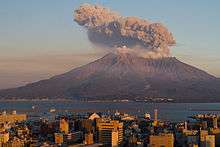
Volcanic eruptions
| Location | Last eruption |
|---|---|
| Mount Meakan, Hokkaido | 2008 |
| Mount Usu, Hokkaido | 2001 |
| Hokkaido Koma-ga-take, Hokkaido | 2000 |
| Mount Asama, Honshu | 2009 |
| Mount Hakkoda, Honshu | 1997 |
| Mount Niigatayake, Honshu | 1998 |
| Mount Yake, Honshu | 1995 |
| Oshima, Izu Islands | 1990 |
| Tori-shima, Izu Islands | 2002 |
| Miyake-jima, Izu Islands | 2010 |
| Mount Aso, Kyushu | 2004 |
| Mount Kuju, Kyushu | 1996 |
| Mount Sakura-jima, Kyushu | 2012 |
| Shinmoe-dake, Kyushu | 2011 |
| Mount Unzen, Kyushu | 1996 |
| Kikai Caldera, Osumi Islands | 2004 |
| Suwanose-jima, Ryukyu Islands | 2012 |
| Fukutoku-Okanoba, Bonin Islands | 2010 |
| Iwo Jima | 1997 |
| Mount Oyama, Miyake-jima | 2005 |
Earthquakes
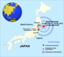
Japan has had a long history of earthquake catastrophe and seismic activity. Earthquakes are the vibrations caused by rocks breaking under stress. The underground surface along which the rock breaks and moves is called a fault plane. Over time, stresses build beneath the earth’s surface. Occasionally, stress is released resulting in the sudden, and sometime disastrous shaking we call an earthquake. Earthquakes can cause shaking that could last seconds or minutes. Besides that, there may be several earthquakes over a period ranging from hours to weeks called aftershocks, and the magnitude of the following tremors will decrease with time. It is important to know the earthquake magnitude because it can be the clue if there will be any aftershocks. Because of that, magnitude can be measured on the Richter scale, invented by Charles F. Richter in 1934. The Richter magnitude is calculated from the amplitude of the largest seismic wave recorded for the earthquake. In the past twenty years, the most severe earthquake that occurred was in 2011 off the coast of Tohoku.
List of earthquakes in Japan
| Location | Date | Estimated deaths |
|---|---|---|
| Hokkaido earthquake | 1993, 12 July | 202 |
| Offshore Sanriku earthquake | 1994, 28 December | 3 |
| Kobe earthquake | 1995, 17 January | 6,434 |
| Ryukyu Islands earthquake | 1998, 4 May | 0 |
| Geiyo earthquake | 2001, 24 March | 2 |
| Hokkaido earthquake | 2003, 25 September | 1 |
| Chuetsu earthquake | 2004, 23 October | 40 |
| Fukuoka earthquake | 2005, 20 March | 1 |
| Miyagi earthquake | 2005, 16 August | 0 |
| Kuril Islands earthquake | 2006, 15 November | 0 |
| Kuril Islands earthquake | 2007, 13 January | 0 |
| Noto earthquake | 2007, 25 March | 1 |
| Chuetsu Offshore earthquake | 2007, 16 July | 11 |
| Iwate-Miyagi Nairiku earthquake | 2008, 14 June | 12 |
| Izu Islands earthquake | 2009, 9 August | 0 |
| Shizuoka earthquake | 2009, 11 August | 1 |
| Ryukyu Islands earthquake | 2010, 26 February | 1 |
| Bonin Islands earthquake | 2010, 21 December | 0 |
| Tohoku earthquake | 2011, 11 March | 15,881 |
| Miyagi earthquake aftershock | 2011, 7 April | 4 |
| Fukushima earthquake | 2011, 11 April | 6 |
| Fukushima earthquake aftershock | 2011, 10 July | 0 |
| Izu Islands earthquake | 2012, 1 January | 0 |
| Kamaishi earthquake | 2012, 7 December | 0 |
| Chiba earthquake | 2012, 14 March | 0 |
Mudslides
A mudslide or mudflow occurs when rocks, sand and earth are loosened and fall from hills and mountains due to earthquake, rain or snow. In Japan, over two-thirds of the land is mountainous and therefore prone to mudslides.[1]
Major mudslide events
Mount Ontake
On September 14, 1984, the Otaki earthquake (magnitude 6.8) in Nagano Prefecture, Japan, caused a major mudslide on the south face of Mount Ontake, which reached speeds of 80~100 km/h.[2] Heavy rain over several days prior to the quake contributed to causing the mudslide, known as “Ontake Kuzure,” which took the lives of 29 people. After the disaster, barriers against mudslide were erected in nine locations at the foot of Mt. Ontake.[3]
Wakayama, Nara
In September 2011, typhoon No. 12, which formed and was named on August 25, made landfall over Japan, bringing heavy rain to the mountainous Kii Peninsula, and causing a mudslide, called “Shinsohokai,” in Wakayama and Nara. "Shinsohokai" means that not only soil collapses, but also bedrock. In this case, houses were covered with earth and sand from the mudslide and there were many injured and killed.[4]
Hiroshima
In June 2010, Hiroshima experienced heavy rains which caused severe damage, including mudslides and river floods; Shōbara had 64 mm rain in an hour and Hiroshima had 30–50 mm on June 12, 20-40mm on the 13th and 20-50mm on the 14th. Five people were killed and six injured; 1,787 houses were destroyed.[5]
Tsunamis
11 March 2011 - the aftermath of the 9.0 earthquake
See also
References
- ↑ "Japan Institute of Country-ology and Engineering". www.jice.or.jp. JICE. 2007. Retrieved 2015-05-25.
- ↑ "Naganoken Seibu Jishin (The earthquake which hit Nagano prefecture)". www.jma-net.go.jp. Matsuhiro Seismological Observatory. Retrieved 2015-05-25.
- ↑ "Naganoken Seibu Jishin (The earthquake which hit Nagano prefecture)". Sabo Gakkaishi. 48 (4): 66–68. 1995. doi:10.11475/sabo1973.48.4_66.
- ↑ "Kii Peninsula mudslide flooding". www.asahi.com. Asahi Sinbun DIGITAL. Retrieved 2015-05-25.
- ↑ "Hiroshima Crisis-Management Department Crisis-Management Division". BOUSAI. Retrieved 2015-05-25.