Mount Unzen
| Mount Unzen | |
|---|---|
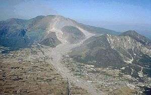 Mt. Unzen, showing extensive pyroclastic flow and lahar deposits | |
| Highest point | |
| Elevation | 1,500 m (4,900 ft) |
| Coordinates | 32°45′24″N 130°17′40″E / 32.75667°N 130.29444°ECoordinates: 32°45′24″N 130°17′40″E / 32.75667°N 130.29444°E |
| Geography | |
| Geology | |
| Age of rock | Oldest 500 kyr[1] |
| Mountain type | Complex stratovolcano |
| Last eruption | February to May 1996 |

Mount Unzen (雲仙岳 Unzen-dake) is an active volcanic group of several overlapping stratovolcanoes, near the city of Shimabara, Nagasaki Prefecture, on the island of Kyūshū, Japan's southernmost main island.
In 1792, the collapse of one of its several lava domes triggered a megatsunami that killed 14,524 people in Japan's worst-ever volcanic-related disaster. The volcano was most recently active from 1990 to 1995, and a large eruption in 1991 generated a pyroclastic flow that killed 43 people, including three volcanologists.
Currently its highest peaks are Fugen-dake (普賢岳) at 1,359 metres (4,459 ft) and Heisei-shinzan (平成新山) at 1,486 metres (4,875 ft). The latter emerged during the eruptions of the early, eponymous Heisei era (1989–).
Eruptive history
Prehistoric to 1989

Mount Unzen is part of Shimabara Peninsula, which has seen extensive volcanism over millions of years. The oldest volcanic deposits in the region date from over 6 million years ago, and extensive eruptions occurred over the whole peninsula between 2.5 and 0.5 million years ago.
The origins of the Unzen complex are traced to the formation of a graben through crustal faulting. This caused parts of the peninsula to subside by up to 1,000 metres (3,300 ft) below sea level and may have caused eruptive activity to localize at one site inside the graben. Eruptions of dacitic lava began from a site slightly to the south of today's Mount Unzen and migrated north over time.
The volcano rapidly grew during its first 200,000 years, forming a large cone. Later eruptions over the following 150,000 years filled in much of the graben. Initially, activity was dominated by blocky andesitic lava and ash flows, changing to dacitic pumice flows and airfall deposits from 500,000 to 400,000 years ago. The period from 400,000 to 300,000 years ago saw the emplacement of large areas of pyroclastic flow and lahar deposits; these form the major part of the volcanic fan surrounding the volcano. Beginning 300,000 to 150,000 years ago, thick phreatomagmatic deposits were laid down, suggesting the subsidence of the volcano into its graben was rapid during this period.
Activity from 150,000 years ago to the present has occurred at a number of sites around the volcanic complex, building four main domes at different times: the No-dake (70–150,000 years old), Myōken-dake (25–40,000 years old), Fugen-dake (younger than 25,000 years old) and Mayu-yama (4,000 years old) volcanic peaks. Fugen-dake has been the site of most eruptions during the past 20,000 years and lies about 6 kilometres (3.7 mi) from the center of Shimabara.
Unzen's deadliest eruption occurred in 1792, with a large dacitic lava flow coming from Fugen-dake. The east flank of the Mayu-yama dome collapsed unexpectedly following a post-eruption earthquake, creating a landslide into Ariake Bay. This caused a megatsunami that reached a height of 100 metres (330 ft), and killed an estimated 15,000 people. As of 2011 it is the worst volcanic related eruption in Japan.[2]
1990–1995


After 1792, the volcano remained dormant until an earthquake swarm began about 20 kilometres (12 mi) underneath and 10 kilometres (6.2 mi) west of Fugendake in November 1989. Over the following year, earthquakes continued, their hypocentres gradually migrating towards the summit. The first phreatic eruptions began in November 1990, and after inflation of the summit area, fresh lava began to emerge on May 20, 1991.[3]
The threat of further disastrous events prompted authorities to evacuate 12,000 local residents from their homes. On June 3, 1991, the volcano erupted violently, possibly as a result of depressurisation of the magma column after a landslide in the crater. A pyroclastic flow triggered by the collapse of a lava dome reached 4.5 kilometres (2.8 mi) from the crater and claimed the lives of 43 scientists and journalists, including volcanologists Katia and Maurice Krafft and Harry Glicken.[4][5]
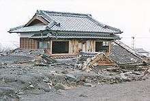
Between 1991 and 1994 the volcano generated at least 10,000 small pyroclastic flows, destroying about 2,000 houses. From 1993 onward, the rate of lava effusion gradually decreased, and eruptions came to an end in 1995. Since then heavy rains have frequently remobilised pyroclastic material, generating lahars. Dikes have been constructed in several river valleys to channel lahar flows away from vulnerable areas, and warning systems and evacuation plans have been developed and deployed.
Mount Unzen was designated a Decade Volcano by the United Nations, in 1991 as part of their International Decade for Natural Disaster Reduction, due to its history of violent activity and location in a densely populated area.
.svg.png)
Unzen Scientific Drilling Project (USDP)
In 1999, an ambitious project began at Mount Unzen to drill deep inside the volcano and sample magma in the 1990–1995 eruption conduit.[6] The project hoped to shed light on some fundamental questions in volcanology, such as why magma repeatedly travels in the same conduits despite the solidification of magma in them at the end of each eruption, and how it can lose enough gas on its ascent to erupt effusively rather than explosively.
Drilling began with test bores to assess the viability of a deep borehole. Two holes were drilled, 750 metres (2,460 ft) and 1,500 metres (4,900 ft) deep, and cores taken from these holes were used to better determine Unzen's eruptive history. One further 350-metre (1,150 ft) deep borehole was drilled to test the methods to be used in the final drilling project.
The main drill began in 2003, starting from the northern flank of the volcano with a 440 mm (17 in) hole at an angle of 25 degrees from vertical. At greater depths, the direction of boring was tilted towards the conduit, reaching an angle of 75 degrees from vertical at a depth of 800 metres (2,600 ft). Drilling reached 1,800 metres (5,900 ft), the original target depth, without reaching the conduit, but in July 2004 at a depth of 1,995 metres (6,545 ft), the conduit was finally reached. The vertical depth below the summit was 1,500 metres (4,900 ft).
The temperature at the conduit was about 155 °C (311 °F), much lower than pre-drill estimations of 500 °C (932 °F) and over. This was attributed to hydrothermal circulation accelerating the cooling of the magma over the nine to ten years since the end of the eruption.
Rivers
Arie River starts at Mount Unzen and flows to the Ariake Sea.
See also
- List of Special Places of Scenic Beauty, Special Historic Sites and Special Natural Monuments
- List of volcanoes in Japan
- List of volcanic eruptions by death toll
- Unzen Ropeway
- Mt. Pinatubo
References
- ↑ http://hakone.eri.u-tokyo.ac.jp/unzen/bgd.htm
- ↑ Johnston, Eric (1 March 2011). "Latest volcano show: Shinmoe". Japan Times. p. 3. Retrieved 5 May 2014.
- ↑ http://hakone.eri.u-tokyo.ac.jp/unzen/chr-1.htm
- ↑ S Connor, The men and women in wooly hats who risk their lives to study volcanoes, The Independent, 22 April 2010.
- ↑ Yamamoto, T.; Takarada, S.; Suto, S. (1993), "Pyroclastic flows from the 1991 eruption of Unzen volcano, Japan", Bulletin of Volcanology, Springer, 55 (3): 166, doi:10.1007/bf00301514
- ↑ Uto, Kozo; Nakada Setsuya ""Unzen Scientific Drilling Project"" (PDF). (519 KB) . Earthquake Research Institute, University of Tokyo. Retrieved 28 October 2010.
Bibliography
- Hoshizumi H., Uto K., Matsumoto A. (2001), Core stratigraphy of the Unzen Scientific Drilling: Volcanic History of the Unzen Volcano, Kyūshū, SW Japan, American Geophysical Union, Fall Meeting 2001
- Hoshizumi H., Uto K., Matsumoto A., Kurihara A. (2004), Growth History Of Unzen Volcano, Kyūshū, Japan, American Geophysical Union, Fall Meeting 2004
- Sakuma S., Nakada S., Uto K. (2004), Unzen Scientific Drilling Project: Challenging drilling operation into the magmatic conduit shortly after eruption, American Geophysical Union, Fall Meeting 2004
- Uto K., Hoshizumi H., Matsumoto A., Oguri K., Nguyen H. (2001), Volcanotectonic history of Shimabara Peninsula and the evolution of Unzen volcano in Southwest Japan, American Geophysical Union, Fall Meeting 2001
- Uto K., Nakada S., Shimizu H., Sakuma S., Hoshizumi H. (2004), Overview and the achievement of the Unzen Scientific Drilling Project, American Geophysical Union, Fall Meeting 2004
External links
| Wikimedia Commons has media related to Mount Unzen. |
- Unzendake – Japan Meteorological Agency (Japanese)
- "Unzendake: National catalogue of the active volcanoes in Japan" (PDF). – Japan Meteorological Agency
- Unzen Volcano – Geological Survey of Japan
- Unzendake – Smithsonian Institution: Global Volcanism Program
- Looking Into a Volcano: Drilling Unzen – Geotimes