National Register of Historic Places listings in Voyageurs National Park
This is a list of the National Register of Historic Places listings in Voyageurs National Park.
This is intended to be a complete list of the properties and districts on the National Register of Historic Places in Voyageurs National Park, Minnesota, United States. The locations of National Register properties and districts for which the latitude and longitude coordinates are included below, may be seen in an online map.[1]
There are eleven properties and districts listed on the National Register in the park.
- This National Park Service list is complete through NPS recent listings posted December 16, 2016.[2]
Current listings
| [3] | Name on the Register | Image | Date listed[4] | Location | City or town | Description |
|---|---|---|---|---|---|---|
| 1 | Archaeological Site No. 21SL82 |  |
(#88000067) |
Address Restricted |
International Falls | Campsite used c. 3000 BCE–1900 CE.[5] |
| 2 | Archeological Site 21SL141 | |
(#87002164) |
Address Restricted |
International Falls | Habitation site occupied c. 300–1900 CE.[5] |
| 3 | Archeological Site 21SL35 | |
(#87002165) |
Address Restricted |
International Falls | Pre-Columbian habitation site.[5] |
| 4 | Archeological Site 21SL55 | |
(#88000989) |
Address Restricted |
International Falls | Campsite used 700–1500 CE.[5] |
| 5 | Archeological Site No. 21SL73 | |
(#88003130) |
Address Restricted |
International Falls | Seasonal campsite used 100 BCE–1500 CE.[5] |
| 6 | Jun Fujita Cabin | 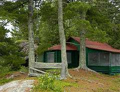 |
(#96001351) |
Wendt Island, Voyageurs National Park 48°32′59″N 92°52′11″W / 48.549828°N 92.869838°W |
Ranier | 1928 rustic cabin of Japanese American photographer and poet Jun Fujita. Also a rare surviving example of the early recreational development of the Boundary Waters.[6] |
| 7 | Gold Mine Sites |  |
(#77000155) |
Around Rainy Lake in Voyageurs National Park 48°36′09″N 93°10′05″W / 48.6025°N 93.168056°W |
Island View | District of seven scattered mine shafts and test pits from an 1894 gold rush that brought industry and settlement to the area.[7] |
| 8 | William Ingersoll Estate | 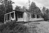 |
(#11000360) |
Ingersoll's Island 48°21′16″N 92°28′23″W / 48.354351°N 92.473104°W |
Crane Lake vicinity | 1920s island summer home complex, whose 1928 main cabin is a rare surviving E. F. Hodgson Company prefabricated kit house.[8] |
| 9 | Kabetogama Ranger Station District | 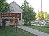 |
(#93000479) |
Southwestern shore of Kabetogama Lake in Voyageurs National Park 48°26′43″N 93°01′47″W / 48.445278°N 93.029722°W |
Ray | Complex built 1933–1941 for the Minnesota Division of Forestry by the Civilian Conservation Corps, an example of federal work relief projects during the Great Depression and National Park Service rustic architecture.[9] |
| 10 | Kettle Falls Historic District | 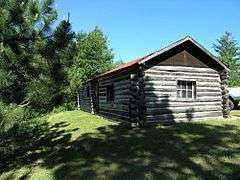 |
(#78000376) |
Kettle Channel in Voyageurs National Park 48°30′05″N 92°38′25″W / 48.501389°N 92.640278°W |
Island View | Ancient portage site and 1914 dam complex.[5] |
| 11 | Kettle Falls Hotel | 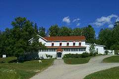 |
(#76000210) |
Kettle Channel in Voyageurs National Park 48°30′11″N 92°38′23″W / 48.503056°N 92.639722°W |
Island View | Remote 1913 frame hotel, only accessible by water. Reopened as the only lodging within Voyageurs National Park.[10] |
| 12 | Little American Mine | 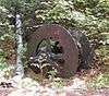 |
(#75000226) |
Little American Island in Voyageurs National Park 48°36′09″N 93°10′05″W / 48.6025°N 93.168056°W |
Island View | Remnants from Minnesota's only profitable gold mine, in operation 1893–1898.[5] Now developed with an interpretive trail.[11] |
See also
- National Register of Historic Places listings in St. Louis County, Minnesota
- National Register of Historic Places listings in Koochiching County, Minnesota
- National Register of Historic Places listings in Minnesota
References
- ↑ The latitude and longitude information provided in this table was derived originally from the National Register Information System, which has been found to be fairly accurate for about 99% of listings. For about 1% of NRIS original coordinates, experience has shown that one or both coordinates are typos or otherwise extremely far off; some corrections may have been made. A more subtle problem causes many locations to be off by up to 150 yards, depending on location in the country: most NRIS coordinates were derived from tracing out latitude and longitudes off of USGS topographical quadrant maps created under the North American Datum of 1927, which differs from the current, highly accurate WGS84 GPS system used by most on-line maps. Chicago is about right, but NRIS longitudes in Washington are higher by about 4.5 seconds, and are lower by about 2.0 seconds in Maine. Latitudes differ by about 1.0 second in Florida. Some locations in this table may have been corrected to current GPS standards.
- ↑ "National Register of Historic Places: Weekly List Actions". National Park Service, United States Department of the Interior. Retrieved on December 16, 2016.
- ↑ Numbers represent an ordering by significant words. Various colorings, defined here, differentiate National Historic Landmarks and historic districts from other NRHP buildings, structures, sites or objects.
- ↑ The eight-digit number below each date is the number assigned to each location in the National Register Information System database, which can be viewed by clicking the number.
- 1 2 3 4 5 6 7 Nord, Mary Ann (2003). The National Register of Historic Places in Minnesota. Minnesota Historical Society. ISBN 0-87351-448-3.
- ↑ Hurley, John (1994-08-15). "National Register of Historic Places Registration Form: Fujita, Jun Cabin" (PDF). National Park Service. Retrieved 2013-03-16.
- ↑ Nagle, Liza; John J. Hackett (1976-09-13). "National Register of Historic Places Registration Form: Gold Mine Sites" (PDF). National Park Service. Retrieved 2013-03-16.
- ↑ "Ingersoll Seasonal Estate-Main Cabin". List of Classified Structures. National Park Service. Retrieved 2014-07-21.
- ↑ Franklin, Rachel (1993-01-14). "National Register of Historic Places Registration Form: Kabetogama Ranger Station District" (PDF). National Park Service. Retrieved 2013-03-18.
- ↑ "Kettle Falls". Voyageurs National Park. National Park Service. 2012-10-09. Retrieved 2012-10-10.
- ↑ National Park Service (2005). "Rainy Lake Gold Rush" (PDF). Lake States Interpretive Association. Retrieved 2013-01-02.
External links
| Wikimedia Commons has media related to National Register of Historic Places in Voyageurs National Park. |
- Minnesota National Register Properties Database—Minnesota Historical Society
- Voyageurs National Park: Places–National Park Service
- Visitor Destinations–National Park Service
| Topics | |
|---|---|
| Lists by states |
|
| Lists by insular areas | |
| Lists by associated states | |
| Other areas | |
| |
This article is issued from Wikipedia - version of the 3/10/2016. The text is available under the Creative Commons Attribution/Share Alike but additional terms may apply for the media files.