National Register of Historic Places listings in Seward County, Nebraska
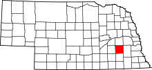
Location of Seward County in Nebraska
This is a list of the National Register of Historic Places listings in Seward County, Nebraska. It is intended to be a complete list of the properties and districts on the National Register of Historic Places in Seward County, Nebraska, United States. The locations of National Register properties and districts for which the latitude and longitude coordinates are included below, may be seen in a map.[1]
There are 9 properties and districts listed on the National Register in the county.
- This National Park Service list is complete through NPS recent listings posted December 16, 2016.[2]
Current listings
| [3] | Name on the Register | Image | Date listed[4] | Location | City or town | Description |
|---|---|---|---|---|---|---|
| 1 | John Cattle, Jr. House | 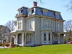 |
(#78001714) |
W. Hillcrest St. 40°54′57″N 97°06′12″W / 40.915833°N 97.103333°W |
Seward | |
| 2 | Deutsche Evangelisch Lutherische Zion Kirche | _from_NE_1.JPG) |
(#82003202) |
3743 Marysville Rd.[5] 40°57′59″N 97°13′46″W / 40.966389°N 97.229444°W |
Staplehurst | Now known as Our Redeemer Lutheran Church[6] |
| 3 | Germantown State Bank Building | 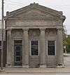 |
(#84000512) |
Main St. 40°56′40″N 96°59′12″W / 40.944444°N 96.986667°W |
Garland | |
| 4 | Harry T. Jones House | 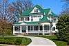 |
(#90001771) |
136 N. Columbia Ave. 40°54′31″N 97°05′28″W / 40.908611°N 97.091111°W |
Seward | |
| 5 | Seward County Courthouse |  |
(#89002245) |
Seward between 5th and 6th Sts. 40°54′26″N 97°05′54″W / 40.90735°N 97.09844°W |
Seward | |
| 6 | Seward County Courthouse Square Historic District | 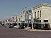 |
(#82003201) |
Roughly bounded by Jackson, 7th, and South Sts. 40°54′27″N 97°05′54″W / 40.9075°N 97.098333°W |
Seward | |
| 7 | States Ballroom | |
(#81000375) |
Off Nebraska Highway 415 41°00′24″N 97°03′31″W / 41.00675°N 97.05853°W |
Bee | |
| 8 | Troyer Site | Upload image | (#95000159) |
Address Restricted |
Milford | |
| 9 | John and Philomena Sand Zimmerer House | 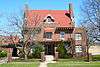 |
(#93000060) |
316 N. 6th St. 40°54′36″N 97°05′54″W / 40.91°N 97.098333°W |
Seward |
See also
| Wikimedia Commons has media related to National Register of Historic Places in Seward County, Nebraska. |
- List of National Historic Landmarks in Nebraska
- National Register of Historic Places listings in Nebraska
References
- ↑ The latitude and longitude information provided in this table was derived originally from the National Register Information System, which has been found to be fairly accurate for about 99% of listings. For about 1% of NRIS original coordinates, experience has shown that one or both coordinates are typos or otherwise extremely far off; some corrections may have been made. A more subtle problem causes many locations to be off by up to 150 yards, depending on location in the country: most NRIS coordinates were derived from tracing out latitude and longitudes off of USGS topographical quadrant maps created under the North American Datum of 1927, which differs from the current, highly accurate WGS84 GPS system used by most on-line maps. Chicago is about right, but NRIS longitudes in Washington are higher by about 4.5 seconds, and are lower by about 2.0 seconds in Maine. Latitudes differ by about 1.0 second in Florida. Some locations in this table may have been corrected to current GPS standards.
- ↑ "National Register of Historic Places: Weekly List Actions". National Park Service, United States Department of the Interior. Retrieved on December 16, 2016.
- ↑ Numbers represent an ordering by significant words. Various colorings, defined here, differentiate National Historic Landmarks and historic districts from other NRHP buildings, structures, sites or objects.
- ↑ The eight-digit number below each date is the number assigned to each location in the National Register Information System database, which can be viewed by clicking the number.
- ↑ "Contact Us". Our Redeemer Lutheran Church and School. Retrieved 2013-06-04.
- ↑ Fagler, James D. "National Register of Historic Places Inventory - Nomination Form: Deutsche Evangelisch Lutherische Zion Kirche". Nebraska State Historical Society. Retrieved 2013-06-04.
| Topics | |
|---|---|
| Lists by states |
|
| Lists by insular areas | |
| Lists by associated states | |
| Other areas | |
| |
Municipalities and communities of Seward County, Nebraska, United States | ||
|---|---|---|
| Cities | ||
| Villages | ||
| CDP | ||
| Unincorporated communities | ||
| Ghost town | ||
This article is issued from Wikipedia - version of the 6/6/2016. The text is available under the Creative Commons Attribution/Share Alike but additional terms may apply for the media files.