National Register of Historic Places listings in Reno County, Kansas
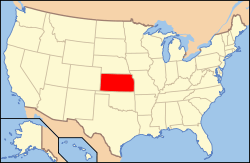
Location of Reno County in Kansas
This is a list of the National Register of Historic Places listings in Reno County, Kansas.
This is intended to be a complete list of the properties and districts on the National Register of Historic Places in Reno County, Kansas, United States. The locations of National Register properties and districts for which the latitude and longitude coordinates are included below, may be seen in a map.[1]
There are 20 properties and districts listed on the National Register in the county.
- This National Park Service list is complete through NPS recent listings posted December 16, 2016.[2]
Current listings
| [3] | Name on the Register[4] | Image | Date listed[5] | Location | City or town | Description |
|---|---|---|---|---|---|---|
| 1 | Downtown Core North Historic District | 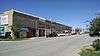 |
(#04000739) |
Generally bounded by BNSF Railway tracks, 1st Ave., west side of N. Main and Poplar St. 38°03′22″N 97°55′50″W / 38.056111°N 97.930556°W |
Hutchinson | Commercial and Industrial Resources of Hutchinson MPS |
| 2 | Downtown Core South Historic District | 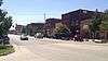 |
(#04000737) |
Generally bounded by C Ave., the alley south of Sherman, and Washington and Poplar Sts. 38°03′07″N 97°55′52″W / 38.051944°N 97.931111°W |
Hutchinson | Commercial and Industrial Resources of Hutchinson MPS |
| 3 | Fox Theater | 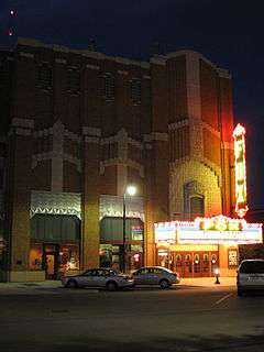 |
(#89001391) |
18 E. First 38°03′16″N 97°55′48″W / 38.054444°N 97.93°W |
Hutchinson | |
| 4 | John P.O. Graber House | 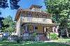 |
(#93001518) |
208 E. 6th St. 38°04′53″N 97°55′37″W / 38.081389°N 97.926944°W |
Hutchinson | |
| 5 | Hamlin Block | 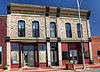 |
(#08000613) |
304-306 S. Main St. 38°02′54″N 97°55′55″W / 38.048333°N 97.931944°W |
Hutchinson | Commercial and Industrial Resources of Hutchinson MPS |
| 6 | Hoke Building | 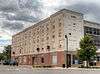 |
(#11000506) |
25 E. 1st Ave. 38°03′11″N 97°55′49″W / 38.053056°N 97.930278°W |
Hutchinson | Commercial and Industrial Resources of Hutchinson MPS |
| 7 | Houston Whiteside Historic District | Upload image | (#04000738) |
Roughly bounded by BNSF Railway, Pershing, Ave. B and Ave. A, and Plum and Elm Sts. 38°03′15″N 97°55′11″W / 38.054167°N 97.919722°W |
Hutchinson | |
| 8 | Hutchinson Public Carnegie Library |  |
(#87000968) |
427 N. Main 38°03′35″N 97°55′51″W / 38.059722°N 97.930833°W |
Hutchinson | |
| 9 | Kansas Sugar Refining Company Mill | 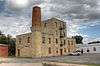 |
(#85000013) |
600 E. 1st St. 38°03′14″N 97°55′04″W / 38.053889°N 97.917778°W |
Hutchinson | |
| 10 | Kelly Mills | 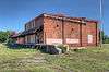 |
(#08000304) |
400-414 S. Main St. 38°02′49″N 97°55′55″W / 38.046944°N 97.931944°W |
Hutchinson | Commercial and Industrial Resources of Hutchinson MPS |
| 11 | G.W. Norris House | Upload image | (#09000876) |
301 E. 12th Ave. 38°03′57″N 97°55′35″W / 38.0659°N 97.9265°W |
Hutchinson | |
| 12 | Ranson Hotel | Upload image | (#08001067) |
4918 E. Main St. 38°08′54″N 97°50′52″W / 38.148333°N 97.847778°W |
Medora | |
| 13 | Reno County Courthouse | 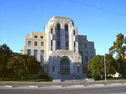 |
(#86003530) |
206 W. 1st 38°03′17″N 97°56′04″W / 38.054722°N 97.934444°W |
Hutchinson | |
| 14 | St. Teresa's Catholic Church |  |
(#94000390) |
211 E. 5th Ave. 38°03′33″N 97°55′38″W / 38.059167°N 97.927222°W |
Hutchinson | |
| 15 | Soldiers and Sailors Memorial | 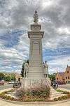 |
(#02000557) |
First Ave. and Walnut St. 38°03′12″N 97°55′47″W / 38.053333°N 97.929722°W |
Hutchinson | |
| 16 | Sylvia Rural High School | Upload image | (#05001247) |
203 Old K-50 37°57′25″N 98°24′33″W / 37.956944°N 98.409167°W |
Sylvia | |
| 17 | Terminal Station | 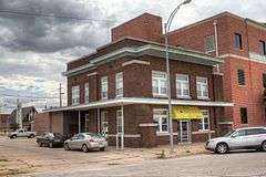 |
(#83003601) |
111 2nd Ave., E. 38°03′16″N 97°55′45″W / 38.054444°N 97.929167°W |
Hutchinson | |
| 18 | US Post Office-Hutchinson | 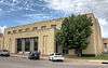 |
(#89001644) |
128 E. First St. 38°03′15″N 97°55′38″W / 38.054167°N 97.927222°W |
Hutchinson | |
| 19 | Wall-Ratzlaff House | Upload image | (#92000443) |
103 N. Maple 38°08′05″N 97°46′09″W / 38.134722°N 97.769167°W |
Buhler | |
| 20 | Frank D. Wolcott House |  |
(#94000408) |
100 W. 20th Ave. 38°04′33″N 97°56′00″W / 38.075833°N 97.933333°W |
Hutchinson |
Former listings
| [3] | Name on the Register | Image | Date listed | Date removed | Location | City or town | Summary |
|---|---|---|---|---|---|---|---|
| 1 | Plevna General Store | Upload image | (#88002968) | 3rd and Main |
Plevna |
See also
| Wikimedia Commons has media related to National Register of Historic Places in Reno County, Kansas. |
- List of National Historic Landmarks in Kansas
- National Register of Historic Places listings in Kansas
References
- ↑ The latitude and longitude information provided in this table was derived originally from the National Register Information System, which has been found to be fairly accurate for about 99% of listings. For about 1% of NRIS original coordinates, experience has shown that one or both coordinates are typos or otherwise extremely far off; some corrections may have been made. A more subtle problem causes many locations to be off by up to 150 yards, depending on location in the country: most NRIS coordinates were derived from tracing out latitude and longitudes off of USGS topographical quadrant maps created under the North American Datum of 1927, which differs from the current, highly accurate WGS84 GPS system used by most on-line maps. Chicago is about right, but NRIS longitudes in Washington are higher by about 4.5 seconds, and are lower by about 2.0 seconds in Maine. Latitudes differ by about 1.0 second in Florida. Some locations in this table may have been corrected to current GPS standards.
- ↑ "National Register of Historic Places: Weekly List Actions". National Park Service, United States Department of the Interior. Retrieved on December 16, 2016.
- 1 2 Numbers represent an ordering by significant words. Various colorings, defined here, differentiate National Historic Landmarks and historic districts from other NRHP buildings, structures, sites or objects.
- ↑ National Park Service (2009-03-13). "National Register Information System". National Register of Historic Places. National Park Service.
- ↑ The eight-digit number below each date is the number assigned to each location in the National Register Information System database, which can be viewed by clicking the number.

Municipalities and communities of Reno County, Kansas, United States | ||
|---|---|---|
| Cities | | |
| CDP | ||
| Unincorporated communities | ||
| Ghost towns | ||
| Townships |
| |
This article is issued from Wikipedia - version of the 4/3/2016. The text is available under the Creative Commons Attribution/Share Alike but additional terms may apply for the media files.