National Register of Historic Places listings in Powell County, Montana
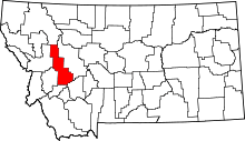
Location of Powell County in Montana
This is a list of the National Register of Historic Places listings in Powell County, Montana.
This is intended to be a complete list of the properties and districts on the National Register of Historic Places in Powell County, Montana, United States. The locations of National Register properties and districts for which the latitude and longitude coordinates are included below, may be seen in a map.[1]
There are 17 properties and districts listed on the National Register in the county, including 1 National Historic Landmark.
- This National Park Service list is complete through NPS recent listings posted December 16, 2016.[2]
Current listings
| [3] |
Name on the Register |
Image |
Date listed[4] |
Location |
City or town |
Description |
|---|
| 1 |
Nick J. Bielenberg House |
Upload image |
000000001979-08-10-0000August 10, 1979
(#79003719) |
801 Milwaukee Ave.
46°24′03″N 112°43′34″W / 46.400833°N 112.726111°W / 46.400833; -112.726111 (Nick J. Bielenberg House) |
Deer Lodge |
|
| 2 |
Charter Oak Mine and Mill |
Upload image |
000000002001-02-06-0000February 6, 2001
(#01000038) |
United States Forest Service Road 227 B-1 in Helena National Forest
46°29′23″N 112°25′03″W / 46.489722°N 112.4175°W / 46.489722; -112.4175 (Charter Oak Mine and Mill) |
Elliston |
|
| 3 |
William E. Coleman House |
Upload image |
000000001979-05-21-0000May 21, 1979
(#79001422) |
500 Missouri Ave.
46°23′55″N 112°43′51″W / 46.398611°N 112.730833°W / 46.398611; -112.730833 (William E. Coleman House) |
Deer Lodge |
|
| 4 |
Conley Street Bridge |
Upload image |
000000002011-04-28-0000April 28, 2011
(#11000227) |
Clark Fork River Crossing on Conley St.
46°23′26″N 112°44′14″W / 46.390556°N 112.737222°W / 46.390556; -112.737222 (Conley Street Bridge) |
Deer Lodge |
Reinforced Concrete Bridges in Montana, 1900-1958 MPS
|
| 5 |
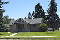
Deer Lodge American Women's League Chapter House |
|
000000001982-06-14-0000June 14, 1982
(#82003177) |
802 Missouri Ave.
46°23′54″N 112°43′38″W / 46.398333°N 112.727222°W / 46.398333; -112.727222 (Deer Lodge American Women's League Chapter House) |
Deer Lodge |
|
| 6 |
Deer Lodge Central Business Historic District |
Upload image |
000000002008-08-13-0000August 13, 2008
(#08000767) |
Roughly bounded by Cottonwood Ave. to the north, Montana Ave. to the south, 2nd St. to the west, and 4th St. to the east
46°23′54″N 112°44′07″W / 46.398414°N 112.735292°W / 46.398414; -112.735292 (Deer Lodge Central Business Historic District) |
Deer Lodge |
|
| 7 |
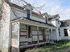
Fitzpatrick Ranch Historic District |
|
000000001981-07-08-0000July 8, 1981
(#81000365) |
Northwest of Avon
46°47′19″N 112°46′38″W / 46.788611°N 112.777222°W / 46.788611; -112.777222 (Fitzpatrick Ranch Historic District) |
Avon |
|
| 8 |
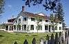
Grant-Kohrs Ranch/Warren Ranch |
|
000000002003-07-11-0000July 11, 2003
(#03000127) |
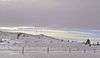
Cattle Drive at Grant-Kohrs Ranch National Historic Site
46°24′57″N 112°44′44″W / 46.415833°N 112.745556°W / 46.415833; -112.745556 (Grant-Kohrs Ranch/Warren Ranch) |
Deer Lodge |
|
| 9 |
Grant-Kohrs Ranch National Historic Site |
|
000000001972-08-25-0000August 25, 1972
(#72000738) |
Edge of Deer Lodge
46°24′31″N 112°44′17″W / 46.408667°N 112.737975°W / 46.408667; -112.737975 (Grant-Kohrs Ranch National Historic Site) |
Deer Lodge |
|
| 10 |
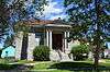
William K. Kohrs Free Memorial Library |
|
000000001979-05-07-0000May 7, 1979
(#79001423) |
5th St. and Missouri Ave.
46°23′56″N 112°43′06″W / 46.398889°N 112.718333°W / 46.398889; -112.718333 (William K. Kohrs Free Memorial Library) |
Deer Lodge |
|
| 11 |
Little Blackfoot River Bridge |
|
000000002010-01-04-0000January 4, 2010
(#09001185) |
Milepost 0 on County Road 186 near its junction with U.S. Route 12
46°34′24″N 112°39′50″W / 46.573375°N 112.663947°W / 46.573375; -112.663947 (Little Blackfoot River Bridge) |
Avon |
|
| 12 |
MacDonald Pass Airway Beacon |
|
000000002014-07-29-0000July 29, 2014
(#14000462) |
United States Route 12
46°33′16″N 112°18′32″W / 46.5545°N 112.309°W / 46.5545; -112.309 (MacDonald Pass Airway Beacon) |
Helena vicinity |
|
| 13 |
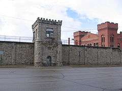
Montana Territorial and State Prison |
|
000000001976-09-03-0000September 3, 1976
(#76001126) |
925 Main St.
46°23′33″N 112°44′07″W / 46.3925°N 112.735278°W / 46.3925; -112.735278 (Montana Territorial and State Prison) |
Deer Lodge |
|
| 14 |
Northern Pacific Railroad Completion Site, 1883 |
Upload image |
000000001983-08-19-0000August 19, 1983
(#83001075) |
Off Interstate 90
46°33′03″N 112°51′36″W / 46.550833°N 112.86°W / 46.550833; -112.86 (Northern Pacific Railroad Completion Site, 1883) |
Goldcreek |
|
| 15 |
Prison Brickyard Historic District |
Upload image |
000000001988-04-14-0000April 14, 1988
(#88000430) |
Gravel road off Interstate 90, ¼ mile south of Deer Lodge
46°23′12″N 112°43′37″W / 46.386667°N 112.726944°W / 46.386667; -112.726944 (Prison Brickyard Historic District) |
Deer Lodge |
|
| 16 |
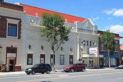
Rialto Theater |
|
000000001998-02-19-0000February 19, 1998
(#98000124) |
418 Main St.
46°24′02″N 112°44′08″W / 46.400556°N 112.735556°W / 46.400556; -112.735556 (Rialto Theater) |
Deer Lodge |
|
| 17 |
Trask Hall |
Upload image |
000000001982-04-30-0000April 30, 1982
(#82003178) |
703 5th Ave.
46°23′40″N 112°43′52″W / 46.394444°N 112.731111°W / 46.394444; -112.731111 (Trask Hall) |
Deer Lodge |
A building at the College of Montana |
See also
References
- ↑ The latitude and longitude information provided in this table was derived originally from the National Register Information System, which has been found to be fairly accurate for about 99% of listings. For about 1% of NRIS original coordinates, experience has shown that one or both coordinates are typos or otherwise extremely far off; some corrections may have been made. A more subtle problem causes many locations to be off by up to 150 yards, depending on location in the country: most NRIS coordinates were derived from tracing out latitude and longitudes off of USGS topographical quadrant maps created under the North American Datum of 1927, which differs from the current, highly accurate WGS84 GPS system used by most on-line maps. Chicago is about right, but NRIS longitudes in Washington are higher by about 4.5 seconds, and are lower by about 2.0 seconds in Maine. Latitudes differ by about 1.0 second in Florida. Some locations in this table may have been corrected to current GPS standards.
- ↑ "National Register of Historic Places: Weekly List Actions". National Park Service, United States Department of the Interior. Retrieved on December 16, 2016.
- ↑ Numbers represent an ordering by significant words. Various colorings, defined here, differentiate National Historic Landmarks and historic districts from other NRHP buildings, structures, sites or objects.
- ↑ The eight-digit number below each date is the number assigned to each location in the National Register Information System database, which can be viewed by clicking the number.
|
|---|
|
| Topics | |
|---|
|
| Lists by states | |
|---|
|
| Lists by insular areas | |
|---|
|
| Lists by associated states | |
|---|
|
| Other areas | |
|---|
|
-
 Portal Portal
-
 WikiProject WikiProject
|
_-_Powell_County%2C_Montana.png)