National Register of Historic Places listings in Meeker County, Minnesota
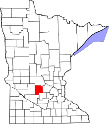
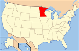
Location of Meeker County in Minnesota
This is a list of the National Register of Historic Places listings in Meeker County, Minnesota.
This is intended to be a complete list of the properties and districts on the National Register of Historic Places in Meeker County, Minnesota, United States. The locations of National Register properties and districts for which the latitude and longitude coordinates are included below, may be seen in an online map.
There are 10 properties and districts listed on the National Register in the county. Another property was once listed but has been removed.
- This National Park Service list is complete through NPS recent listings posted December 16, 2016.[1]
Current listings
| [2] | Name on the Register | Image | Date listed[3] | Location | City or town | Description |
|---|---|---|---|---|---|---|
| 1 | Henry Ames House | 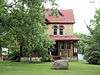 |
(#84001623) |
Minnesota Highway 24 45°08′54″N 94°29′55″W / 45.148452°N 94.498698°W |
Litchfield | 1888 brick house of a notable local contractor.[4] |
| 2 | Bridge No. 90980 | 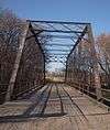 |
(#96001560) |
County Road 190 over the North Fork of the Crow River 45°12′08″N 94°22′45″W / 45.202092°N 94.37917°W |
Forest City | 1899 steel Pratt through truss bridge.[4] |
| 3 | Brightwood Beach Cottage | 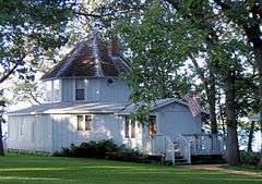 |
(#78001551) |
S. Ripley Dr. 45°05′54″N 94°32′22″W / 45.098285°N 94.539338°W |
Litchfield | 1889 octagon house built as part of a resort.[4] |
| 4 | District No. 48 School | 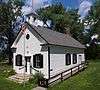 |
(#96001612) |
17757 745th Ave. 45°03′54″N 94°15′40″W / 45.064972°N 94.260997°W |
Dassel | 1870 frame one-room schoolhouse.[4] |
| 5 | Grand Army of the Republic Hall | 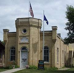 |
(#75000995) |
370 N. Marshall St. 45°07′45″N 94°31′35″W / 45.129137°N 94.526322°W |
Litchfield | 1885 brick Grand Army of the Republic meeting hall.[4] Now part of the Meeker County Historical Society Museum.[5] |
| 6 | Litchfield Commercial Historic District |  |
(#96000192) |
N. Sibley Ave. between Depot and 3rd Sts. 45°07′39″N 94°31′41″W / 45.127404°N 94.528111°W |
Litchfield | Late-19th and early-20th century buildings of an agricultural commerce hub.[4] |
| 7 | Litchfield Opera House |  |
(#84000019) |
126 N. Marshall Ave. 45°07′38″N 94°31′35″W / 45.127263°N 94.526311°W |
Litchfield | 1900 brick Renaissance Revival performance hall.[4] |
| 8 | Pipe Lake Fort | Upload image | (#03000576) |
Off County Road 1, Cedar Mills Township[6] 44°55′56″N 94°35′44″W / 44.932222°N 94.595556°W |
Cosmos | Remnants of the state's only surviving sod fort, one of 12 military forts built in Minnesota in 1863 following the Dakota War of 1862.[7] |
| 9 | Trinity Episcopal Church | .jpg) |
(#75000996) |
400 N. Sibley Ave. 45°07′48″N 94°31′40″W / 45.130041°N 94.527775°W |
Litchfield | Superlative Carpenter Gothic church built in 1871, believed to have been designed by Richard Upjohn.[8] |
| 10 | Universal Laboratories Building | .jpg) |
(#96000191) |
901 1st St., N. 45°05′10″N 94°18′28″W / 45.086195°N 94.30779°W |
Dassel | 1937 facility that became the key U.S. processor of ergot for drug manufacturing, a novel and timely enterprise on the eve of World War II.[9] Now houses a local history museum.[10] |
Former listing
| [2] | Name on the Register | Image | Date listed | Date removed | Location | City or town | Summary |
|---|---|---|---|---|---|---|---|
| 1 | West End Elevator | Upload image | (#85000556) | 4th St. and Atlantic Ave. |
Dassel | 1885 grain elevator.[11] Burned down in 1987.[4] |
See also
- List of National Historic Landmarks in Minnesota
- National Register of Historic Places listings in Minnesota
References
- ↑ "National Register of Historic Places: Weekly List Actions". National Park Service, United States Department of the Interior. Retrieved on December 16, 2016.
- 1 2 Numbers represent an ordering by significant words. Various colorings, defined here, differentiate National Historic Landmarks and historic districts from other NRHP buildings, structures, sites or objects.
- ↑ The eight-digit number below each date is the number assigned to each location in the National Register Information System database, which can be viewed by clicking the number.
- 1 2 3 4 5 6 7 8 Nord, Mary Ann (2003). The National Register of Historic Places in Minnesota. Minnesota Historical Society. ISBN 0-87351-448-3.
- ↑ "The Meeker County Historical Society Museum & G.A.R. Hall". Retrieved 2013-02-17.
- ↑ Pipe Lake Fort, Minnesota Historical Society, n.d. Accessed 2016-05-05.
- ↑ Dudzik, Mark J. "The Pipe Lake Sod Fort: A Dakota Conflict Era (1862-1863) Military Fortification". Minnesota Office of the State Archaeologist. Retrieved 2016-05-05.
- ↑ Atkinson, Florence D.; Edward V. Lofstrom (1975-02-25). "National Register of Historic Places Inventory -- Nomination Form: Trinity Episcopal Church" (PDF). National Park Service. Retrieved 2016-01-01.
- ↑ "To Market: Universal Laboratories Building". Minnesota from the Railroad. Minnesota Historical Society. 2007. Retrieved 2013-02-17.
- ↑ "Museum". City of Dassel. Retrieved 2013-02-26.
- ↑ "West End Elevator (removed)". Minnesota National Register Properties Database. Minnesota Historical Society. 2009. Retrieved 2013-01-17.
External links
| Wikimedia Commons has media related to National Register of Historic Places in Meeker County, Minnesota. |
- Minnesota National Register Properties Database—Minnesota Historical Society

This article is issued from Wikipedia - version of the 8/26/2016. The text is available under the Creative Commons Attribution/Share Alike but additional terms may apply for the media files.