National Register of Historic Places listings in Cherry County, Nebraska
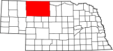
Location of Cherry County in Nebraska
This is a list of the National Register of Historic Places listings in Cherry County, Nebraska. It is intended to be a complete list of the properties and districts on the National Register of Historic Places in Cherry County, Nebraska, United States. The locations of National Register properties and districts for which the latitude and longitude coordinates are included below, may be seen in a map.[1]
There are 13 properties and districts listed on the National Register in the county.
- This National Park Service list is complete through NPS recent listings posted December 16, 2016.[2]
Current listings
| [3] | Name on the Register | Image | Date listed[4] | Location | City or town | Description |
|---|---|---|---|---|---|---|
| 1 | Adamson Bridge | 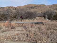 |
(#92000749) |
Nebraska Highway 97 over the Niobrara River, 7.8 miles southwest of Valentine 42°48′26″N 100°40′20″W / 42.807222°N 100.672222°W |
Valentine | Located on a different road alignment than the current crossing (a concrete beam bridge built c. 1994[5]), this bridge seems to be gone based on aerial photo view of its coordinates and on photos taken at the site in 2014. |
| 2 | Bell Bridge | _2.JPG) |
(#92000752) |
County road over the Niobrara River, 11.9 miles northeast of Valentine 42°53′42″N 100°19′20″W / 42.895°N 100.322222°W |
Valentine | Bridge built in 1903; one of oldest surviving Pratt through truss bridges in Cherry County and the state; one of only four bridges in the county surviving ice melt flood of 1916. |
| 3 | Berry State Aid Bridge | |
(#92000753) |
County road over the Niobrara River, 10 miles northeast of Valentine 42°54′07″N 100°21′44″W / 42.901944°N 100.362222°W |
Valentine | Built 1920-21, replacing one of the four that survived. |
| 4 | Borman Bridge | _from_SE_2.JPG) |
(#92000751) |
County road over the Niobrara River, 2.3 miles southeast of Valentine 42°51′07″N 100°31′15″W / 42.851944°N 100.520833°W |
Valentine | Pinned Pratt through truss 1916 replacement for one of the bridges that was destroyed in the flood. |
| 5 | Brewer Bridge | 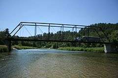 |
(#92000754) |
County road over the Niobrara River, 14.7 miles east of Valentine 42°52′34″N 100°15′58″W / 42.876111°N 100.266111°W |
Valentine | |
| 6 | Bryan Bridge | 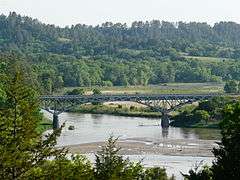 |
(#88000912) |
U.S. Route 20 42°49′56″N 100°31′41″W / 42.832222°N 100.528056°W |
Valentine | |
| 7 | Cherry County Courthouse | 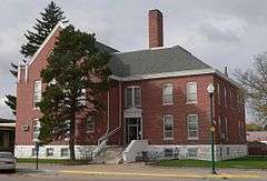 |
(#89002229) |
4th and Main Sts. 42°52′34″N 100°33′04″W / 42.876111°N 100.551111°W |
Valentine | |
| 8 | Dry Valley Church and Cemetery | 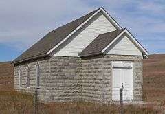 |
(#07000660) |
West of Nebraska Highway 97 north of Mullen[6] 42°15′50″N 101°05′10″W / 42.263889°N 101.086111°W |
Mullen | |
| 9 | Spade Ranch | |
(#80002464) |
Northwest of Ellsworth 42°18′23″N 102°04′47″W / 42.306389°N 102.079722°W |
Ellsworth | |
| 10 | Twin Bridge | _from_S_bank_3.JPG) |
(#92000750) |
North Loup River, 7.9 miles northwest of Brownlee 42°20′00″N 100°45′45″W / 42.333332°N 100.762407°W |
Brownlee | |
| 11 | US Post Office-Valentine | |
(#91001750) |
348 N. Main St. 42°52′32″N 100°33′01″W / 42.87564°N 100.55029°W |
Valentine | One of 12 Nebraska post offices featuring a Section of Fine Arts mural.[7] The $700 mural in the post office was both praised and panned when it was originally produced.[8] Now the Valentine Media Center, operated by Educational Service Unit #17.[9] |
| 12 | Valentine Public School | _from_SW_1.JPG) |
(#84002454) |
3rd and Macomb Sts. 42°52′31″N 100°32′49″W / 42.87541°N 100.54702°W |
Valentine | Now operated as a museum.[10] |
| 13 | F.M. Walcott House | _from_E_2.JPG) |
(#82000599) |
431 N. Hall St. 42°52′40″N 100°32′58″W / 42.877694°N 100.549444°W |
Valentine | Deemed locally significant architecturally "as an example of a vernacular Neo-Classical Revival dwelling, based upon earlier upright-with-wing or templeform houses common to the Greek Revival style in the eastern and midwestern states" and for association with F. M. Walcott, a county attorney and county judge who had one of the largest legal practices in Nebraska.[11] |
See also
- List of National Historic Landmarks in Nebraska
- National Register of Historic Places listings in Nebraska
References
- ↑ The latitude and longitude information provided in this table was derived originally from the National Register Information System, which has been found to be fairly accurate for about 99% of listings. For about 1% of NRIS original coordinates, experience has shown that one or both coordinates are typos or otherwise extremely far off; some corrections may have been made. A more subtle problem causes many locations to be off by up to 150 yards, depending on location in the country: most NRIS coordinates were derived from tracing out latitude and longitudes off of USGS topographical quadrant maps created under the North American Datum of 1927, which differs from the current, highly accurate WGS84 GPS system used by most on-line maps. Chicago is about right, but NRIS longitudes in Washington are higher by about 4.5 seconds, and are lower by about 2.0 seconds in Maine. Latitudes differ by about 1.0 second in Florida. Some locations in this table may have been corrected to current GPS standards.
- ↑ "National Register of Historic Places: Weekly List Actions". National Park Service, United States Department of the Interior. Retrieved on December 16, 2016.
- ↑ Numbers represent an ordering by significant words. Various colorings, defined here, differentiate National Historic Landmarks and historic districts from other NRHP buildings, structures, sites or objects.
- ↑ The eight-digit number below each date is the number assigned to each location in the National Register Information System database, which can be viewed by clicking the number.
- ↑ "N97 over Niobrara River". Uglybridges.com. Retrieved 2012-11-26.
- ↑ Dry Valley Church, Hooker County, 2009. Accessed 2013-04-16.
- ↑ Ahlgren, Carol (August 1991). "National Register of Historic Places Multiple Property Documentation Form: Nebraska Post Offices Which Contain Section Artwork (1938-1942)" (PDF). Retrieved 2013-01-28.
- ↑ David Hendee (November 15, 2012). "The post-Depression post office murals of Nebraska". Omaha World-Herald. (see Valentine mural visible in 4th clickable photo)
- ↑ "Welcome to Educational Service Unit #17". Retrieved 2012-11-26.
- ↑ "Museums". Valentine Chamber of Commerce. Retrieved 2012-11-26.
- ↑ Randel Anderson and Joni Gilkerson (August 1992). "National Register of Historic Places Inventory/Nomination: F.M. Walcott House" (PDF). National Park Service. and accompanying six photos from 1980
External links
| Wikimedia Commons has media related to National Register of Historic Places in Cherry County, Nebraska. |
- Nebraska National Register Sites in Cherry County–Nebraska State Historical Society
| Topics | |
|---|---|
| Lists by states |
|
| Lists by insular areas | |
| Lists by associated states | |
| Other areas | |
| |
Municipalities and communities of Cherry County, Nebraska, United States | ||
|---|---|---|
| City | ||
| Villages | ||
| CDP | ||
| Other unincorporated communities | ||
| Ghost towns | ||
This article is issued from Wikipedia - version of the 6/5/2016. The text is available under the Creative Commons Attribution/Share Alike but additional terms may apply for the media files.