Mulberry River Bridge (Pleasant Hill, Arkansas)
|
Mulberry River Bridge | |
|
Mulberry Bridge under rehabilitation, August 2011 | |
  | |
| Nearest city | Pleasant Hill, Arkansas |
|---|---|
| Coordinates | 35°31′57″N 94°2′27″W / 35.53250°N 94.04083°WCoordinates: 35°31′57″N 94°2′27″W / 35.53250°N 94.04083°W |
| Area | less than one acre |
| Built | 1912/1929 |
| Architect | Lakeside Bridge & Steel Co. |
| Architectural style | Pratt through truss |
| MPS | Historic Bridges of Arkansas MPS |
| NRHP Reference # | 06001272[1] |
| Added to NRHP | January 24, 2007 |
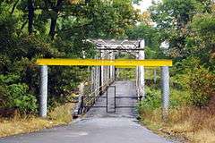
The Mulberry River Bridge, also known as the Silver Bridge and the Wire Ford Bridge,[2] is a historic bridge Pratt through truss bridge northeast of Pleasant Hill, Arkansas, now a neighborhood of the city of Mulberry. The bridge (which is closed for renovations) normally carries Wire Road/Center Point Road across the Mulberry River. The bridge has three spans, set on metal caissons filled with concrete, and has a total length of 342 feet (104 m). Each span measures 105 feet (32 m), and has a deck width of 12 feet (3.7 m) and a vertical clearance of 13 feet (4.0 m).[3] In 1927 it was rebuilt when two of the three spans were washed out by the Mulberry River.[2] The bridge is the last known multi-span Pratt through truss bridge in the state.[3]
The bridge was listed on the National Register of Historic Places in 2007.[1]
See also
- Mulberry River Bridge (Turner's Bend, Arkansas), also NRHP-listed
- National Register of Historic Places listings in Franklin County, Arkansas
- National Register of Historic Places listings in Crawford County, Arkansas
- List of bridges on the National Register of Historic Places in Arkansas
References
- 1 2 National Park Service (2009-03-13). "National Register Information System". National Register of Historic Places. National Park Service.
- 1 2 http://bridgehunter.com/ar/franklin/mulberry-67/
- 1 2 "NRHP nomination for Mulberry River Bridge" (PDF). Arkansas Preservation. Retrieved 2015-04-01.
| Topics | |
|---|---|
| Lists by states |
|
| Lists by insular areas | |
| Lists by associated states | |
| Other areas | |
| |