Mount Morris Park Historic District
|
Mount Morris Park Historic District | |
   | |
| Location |
Bounded roughly by Lenox Ave., Mount Morris Park West, and W. 124th and W. 119th Sts., (original) |
|---|---|
| Coordinates | 40°48′17″N 73°56′49″W / 40.80472°N 73.94694°WCoordinates: 40°48′17″N 73°56′49″W / 40.80472°N 73.94694°W |
| Built | 1878 |
| Architect | Multiple; including in the increase: Angell, Edward L.; Baxter, Charles |
| Architectural style |
Queen Anne, Late 19th- and 20th-century Revivals, Romanesque (original) Beaux Arts, Second Empire, Renaissance (increase) |
| NRHP Reference # | 73001221 |
| Added to NRHP |
February 06, 1973 (original) May 24, 1996 (increase)[1] |
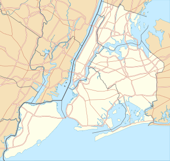
Mount Morris Park Historic District was designated a historic district by New York City Landmarks Preservation Commission in 1971, and is part of the larger Mount Morris Park neighborhood. It is a large 16-block area in west central Harlem. The boundaries are West 118th and West 124th Streets, Fifth Avenue, and Adam Clayton Powell Jr. Boulevard (Seventh Avenue).[2] "Doctor's Row" comprises the nearby stretch of West 122nd Street, Mount Morris Park West and Malcolm X Boulevard; one of the doctors of "Doctor's Row" was the father of the composer Richard Rodgers. Mount Morris Square, the core of the district, is now called Marcus Garvey Park.
Early history
Before the European settlements, the rocky hill of Manhattan mica-schist was used by the Native Americans as a lookout station to see over the entire island. The nearness of the Harlem River made Slang Berg a militarily strategic location.
Despite the 18th-century local prominence of the Gouverneur Morris family,[3] the name "Mount Morris" for the rocky formation, one of two the Dutch called the Ronde Gerbergte is of 19th-century origin:
"One is an abrupt wooded eminence, by modern innovation styled Mount Morris, but which the Dutch called Slang Berg, or Snake Hill, from the reptile tribes that infested its cleft rocks and underbrush even within memory of the living. Southerly from it the gneiss rock crops out in huge, disordered masses. A little way to the right[4] is... a lesser height or ridge, and which to the inhabitants came to be known as the Little Hill.[5]
Little Hill was leveled when the right-of-way was graded for the New York and Harlem Railroad, following the present route of Park Avenue.[6]
On September 4, 1839, a 20-acre (81,000 m2) residential square, on land which was formerly a race track for horses, out of 173 acres (0.70 km2) of a land grant farm owned by the Benson family, was set aside.[7] The square was resited from the Commissioners' Plan of 1811, which had planned for a square in the neighborhood, in order to take advantage of the rugged topography that stood squarely in the path of Fifth Avenue.

"Mount Morris Square" was officially opened December 1, 1840. Robert H. Morris, a client of the Tammany Hall political machine who had recently been removed from his position as Recorder of the City, had recently been elected Mayor of New York; he served several terms, 1841-1844. The new square that existed on paper remained unimproved for decades. It was landscaped in 1869, to a plan by the City surveyor Ignaz Pilat,[8] for which the Central Park Commission allocated $15,000. Walks were graded and the sloping path to the summit was constructed; by the next spring, the New York Times predicted, "croquet playing, decent picnic parties, and a band of music will attract not only the inhabitants of Harlem, but those of New-York"[9] Blocks of the original rusticated retaining walls, akin to the stonework that surrounds Central Park, can still be seen, though vandals have overthrown many stretches of walling.
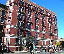
Late 19th- and early 20th-century residential row houses and church architecture fill Mount Morris Park Historic District. There are several unaltered streetscapes. Romanesque Revival, neo-Grec, Queen Anne, and 1893's World Columbian Exposition in Chicago were among the influences that created the eclectic style from the Gilded Age.
Community
In the 1930s, New York City Parks Commissionmer Robert Moses installed playgrounds and a pool. The Boys Choir of Harlem was established in the neighborhood in 1968.[10]
In 1973, the name of the land was changed to Marcus Garvey Park. This was in honor of the international Pan-African movement leader. In 1973, a part of the current district was listed on the National Register of Historic Places.[1]
In 1981, the Mount Morris Park Community Association (MMPCIA) was created.[11] The organization promotes the preservation of buildings such as Apollo Theatre, National Black Theatre. It has also supported the Schomburg Center for Research in Black Culture and the Studio Museum in Harlem. The MMPCIA sponsored annual Historic Neighborhood House Tours, held on the second week of June.[12] The association features historic brownstones and landmark buildings open for the public to view. In 1996, the boundaries of Mount Morris Park District were expanded. They were pushed west to include blocks between Lenox Avenue and Seventh Avenue, and south to include some of West 118th Street.[1] An extension is contemplated to reflect the area on National Register of Historic Places.
References
- 1 2 3 4 National Park Service (2008-04-15). "National Register Information System". National Register of Historic Places. National Park Service.
- ↑ "Expanding Historic District Boundaries- Mount Morris Park." Historic Districts Council.
- ↑ "On Harlem Heights, Colonel Roger Morris and his wife Mary Philpse, were building Mount Morris, a beautiful Georgian showplace commanding a view down the length of Manhattan," observe Edwin G. Burrows and Mike Wallace, 1999. Gotham: A History of New York City to 1898 p. 179; the house they refer to exists, as the Morris-Jumel Mansion, sometimes also called "Mount Morris".
- ↑ As seen from McGown's Pass to the south.
- ↑ James Riker, 1881. Harlem (City of New York): its origin and early annals, quoted in Eric W. Sanderson, et al. 2009. Mannahatta: a natural history of New York City, p. 256.
- ↑ Sanderson 2009.
- ↑ MMPCIA: Mount Morris Park Historic District
- ↑ East Harlem: Marcus Garvey Park.
- ↑ The New York Times, September 21, 1869.
- ↑ Petri, E. R. "Mt. Morris Park, Manhattan", Forgotten New York, May 3, 2009, accessed March 1, 2014
- ↑ Mount Morris Park Community Association
- ↑ Mount Morris Park House Tour Showcases Historic Homes, Jeff Mays, DNA Info, on 2012-05-30.
| Topics | |
|---|---|
| Lists by states |
|
| Lists by insular areas | |
| Lists by associated states | |
| Other areas | |
| |