Jeffersonville, Vermont
| Jeffersonville, Vermont | |
|---|---|
| Village | |
| Nickname(s): Jeffertonsville | |
| Motto: "The Center Must Hold" | |
 Jeffersonville Location within the state of Vermont | |
| Coordinates: 44°38′37″N 72°49′46″W / 44.64361°N 72.82944°W | |
| Country | United States |
| State | Vermont |
| County | Lamoille |
| Area | |
| • Total | 0.80 sq mi (2.08 km2) |
| • Land | 0.78 sq mi (2.01 km2) |
| • Water | 0.03 sq mi (0.07 km2) |
| Elevation | 1,060 ft (323.1 m) |
| Population (2010) | |
| • Total | 729 |
| • Density | 939/sq mi (362.7/km2) |
| Time zone | Eastern (EST) (UTC-5) |
| • Summer (DST) | EDT (UTC-4) |
| ZIP code | 05464 |
| Area code(s) | 802 |
| FIPS code | 50-36475[1] |
| GNIS feature ID | 1457997[2] |
Jeffersonville is a village in the town of Cambridge, Vermont, United States. The population was 729 at the 2010 census,[3] up from 568 at the 2000 census.
History
The village was originally called Cambridge Center. The name was changed to Jeffersonville in 1827 to honor Thomas Jefferson.[4] The village was incorporated in 1897.[5]
Geography
According to the United States Census Bureau, the village has a total area of 0.81 square miles (2.1 km2), of which 0.03 square miles (0.07 km2), or 3.25%, is water.[3] The village is located near the geographic center of the town of Cambridge, along the south bank of the Lamoille River where it is joined by the Brewster River. Jeffersonville is 25 miles North-east of the city of Burlington, Vermont. Jeffersonville sits at 1,060 feet above sea level, surrounded by higher standing mountains, such as Mount Mansfield (the highest peak in Vermont at 4,393 feet [1,339m])), 4 miles to the east.
Climate
Jeffersonville has a humid continental climate (Köppen Dfb), with very cold winters and warm, humid summers. The monthly daily average temperatures ranges from 12 °F (−11.1 °C) in January to 64.4 °F (18 °C) in July. The annual precipitation is significant, averaging 72.3 inches (1703.6 mm) and is well-distributed throughout the year, but the latter months are the wettest. The town's location east of Lake Champlain sometimes accounts for localized snow squalls, producing up to 18 inches (45.7 cm) in 12 hours on rare occasions.[20] Annual snowfall is significant, averaging 331.4 inches (841.2 cm). Extremes have ranged from −38 °F (−38.8 °C) on January 28, 1994 to 89 °F (31 °C) on June 28, 2003 and July 26, 1989.[17] The most snowfall from a single storm is 73.1 inches (185.7 cm), which fell January 2–4, 2010.[21]
Climate data for Jeffersonville (Jeffersonville, Vermont), 1981–2010 normals, extremes 1981–present[a] Month Jan Feb Mar Apr May Jun Jul Aug Sep Oct Nov Dec Year Record high °F (°C) 59 (15) 60 (15) 71 (21) 83 (28) 84 (28) 89 (31) 89 (31) 88 (31) 87 (30) 75 (24) 67 (19) 62 (17) 89 (31) Average high °F (°C) 23.1 (-5) 26.4 (-3.1) 31.9 (-.05) 46.2 (7.8) 60 (15.5) 69.8 (20.5) 74.1 (23.4) 71.6 (22) 65 (18.3) 50 (10) 38.1 (3.3) 28 (-2.2) 48.3 (9) Daily mean °F (°C) 12 (-11.1) 15 (-9.4) 23.2 (-4.9) 37.1 (2.8) 50 (10) 61 (16.1) 64.4 (18) 62.6 (17) 55 (12.8) 42.3 (5.7) 31.7 (-.1) 19.2 (-7.1) 39.2 (4) Average low °F (°C) 1.1 (−17.2) 4.9 (−15) 14.5 (-9.7) 27 (-2.7) 41.3 (5.2) 51.6 (10.8) 55.8 (13.2) 54.3 (12.4) 45.1 (7.3) 32 (0) 22.2 (-5.4) 10 (-12.2) 29.7 (-1.3) Record low °F (°C) −38 (−38.8) −34 (−36.6) -22 (−30) -3 (−19) 21 (-6.1) 28 (-2.2) 35 (1.7) 30 (-1.1) 15 (-9.4) 10 (−12.2) -12 (−24) −29 (−33.9) −38 (−38.8) Average precipitation inches (mm) 5.2 (132.8) 4.6 (116.8) 4.1 (104.1) 4.4 (111.7) 6.1 (154.5) 5.8 (147.3) 6.1 (154.5) 6.2 (157.5) 5.4 (137.2) 6.8 (172.3) 5.8 (147.3) 6.6 (167.6) 72.3 (1703.6) Average snowfall inches (cm) 67.0 (170.8) 61.3 (155.7) 55.2 (140.2) 21.3 (54.1) 5.6 (14.6) 1.3 (3.3) 0 (0) 0.1 (.3) 2.8 (7.1) 17.1 (43.4) 36.4 (92.5) 63.2 (160.5) 331.4 (841.8) Avg. precipitation days (≥ 0.01 in) 20.3 18 14.3 17.8 18.2 17.2 15.4 16.2 13.3 14.4 19.6 22.6 207.3 Avg. snowy days (≥ 0.1 in) 19.8 16.8 12.8 13.3 6.2 1.1 0 0.1 1.3 5.2 8.2 14.3 20.4 Source: WCC
Demographics
| Historical population | |||
|---|---|---|---|
| Census | Pop. | %± | |
| 1930 | 305 | — | |
| 1940 | 287 | −5.9% | |
| 1950 | 387 | 34.8% | |
| 1960 | 346 | −10.6% | |
| 1970 | 382 | 10.4% | |
| 1980 | 491 | 28.5% | |
| 1990 | 462 | −5.9% | |
| 2000 | 568 | 22.9% | |
| 2010 | 729 | 28.3% | |
| Est. 2015 | 753 | [6] | 3.3% |
As of the census[1] of 2000, there were 568 people, 248 households, and 150 families residing in the village. The population density was 714.3 people per square mile (274.1/km²). There were 254 housing units at an average density of 319.4/sq mi (122.6/km²). The racial makeup of the village was 98.06% White, and 1.94% from two or more races. Hispanic or Latino of any race were 0.88% of the population.
There were 248 households out of which 29.4% had children under the age of 18 living with them, 48.4% were married couples living together, 8.9% had a female householder with no husband present, and 39.5% were non-families. 29.0% of all households were made up of individuals and 11.7% had someone living alone who was 65 years of age or older. The average household size was 2.29 and the average family size was 2.85.
In the village the population was spread out with 23.8% under the age of 18, 9.7% from 18 to 24, 35.2% from 25 to 44, 20.6% from 45 to 64, and 10.7% who were 65 years of age or older. The median age was 32 years. For every 100 females there were 97.2 males. For every 100 females age 18 and over, there were 95.0 males.
The median income for a household in the village was $38,333, and the median income for a family was $48,929. Males had a median income of $35,375 versus $23,036 for females. The per capita income for the village was $20,323. About 1.3% of families and 6.6% of the population were below the poverty line, including 3.2% of those under age 18 and 17.6% of those age 65 or over.
Education
- Students in public school Pre-Kindergarten through sixth grade attend Cambridge Elementary School in Jeffersonville, VT (318 students).
- For grades 7 - 8, public school students attend Lamoille Union Middle School in Hyde Park, VT (274 students).
- For grades 9 - 12, public school students attend Lamoille Union High School in Hyde Park, VT (601 students).
Sites of interest
- Smugglers' Notch Resort, 5 miles (8 km) south of the village
- Smugglers Notch, mountain pass 9 miles (14 km) south of the village
Notable people
- Scott Buchanan, educator, philosopher, and foundation consultant; raised in Jeffersonville
Coordinates: 44°38′38″N 72°49′45″W / 44.64389°N 72.82917°W
References
- 1 2 "American FactFinder". United States Census Bureau. Retrieved 2008-01-31.
- ↑ "US Board on Geographic Names". United States Geological Survey. 2007-10-25. Retrieved 2008-01-31.
- 1 2 "Geographic Identifiers: 2010 Demographic Profile Data (G001): Jeffersonville village, Vermont". U.S. Census Bureau, American Factfinder. Retrieved September 30, 2014.
- ↑ Virtual Vermont: About Jeffersonville, Vermont Retrieved 2011-06-30.
- ↑ City-Data.com: Jeffersonville, Vermont Retrieved 2011-06-30.
- ↑ "Annual Estimates of the Resident Population for Incorporated Places: April 1, 2010 to July 1, 2015". Retrieved July 2, 2016.
- ↑ "Census of Population and Housing". Census.gov. Retrieved June 4, 2015.
Municipalities and communities of Lamoille County, Vermont, United States | ||
|---|---|---|
| Towns | 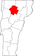 | |
| Villages | ||
| CDP | ||
| Unincorporated community | ||