Montaigut-le-Blanc, Puy-de-Dôme
| Montaigut-le-Blanc | |
|---|---|
|
View of the town of Montaigut-le-Blanc with the village of St. Julien in the background and Montaigut-le-Blanc dominated by its castle on the hill in the background | |
 Montaigut-le-Blanc | |
|
Location within Auvergne-Rhône-Alpes region  Montaigut-le-Blanc | |
| Coordinates: 45°35′13″N 3°05′26″E / 45.5869°N 3.0906°ECoordinates: 45°35′13″N 3°05′26″E / 45.5869°N 3.0906°E | |
| Country | France |
| Region | Auvergne-Rhône-Alpes |
| Department | Puy-de-Dôme |
| Arrondissement | Issoire |
| Canton | Champeix |
| Intercommunality | Communauté de communes des Puys et Couzes |
| Government | |
| • Mayor (2008–2014) | Christian Chabaud[1] |
| Area1 | 22.26 km2 (8.59 sq mi) |
| Population (1999)2 | 601 |
| • Density | 27/km2 (70/sq mi) |
| Time zone | CET (UTC+1) |
| • Summer (DST) | CEST (UTC+2) |
| INSEE/Postal code | 63234 / 63320 |
| Elevation |
474–879 m (1,555–2,884 ft) (avg. 500 m or 1,600 ft) |
|
1 French Land Register data, which excludes lakes, ponds, glaciers > 1 km² (0.386 sq mi or 247 acres) and river estuaries. 2 Population without double counting: residents of multiple communes (e.g., students and military personnel) only counted once. | |

Montaigut-le-Blanc in the commune in the Puy-de-Dôme department in Auvergne in central France.
Photogallery
 Montaigut-le-Blanc with the castle
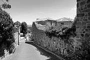 A street in the village of Montaigut-le-Blanc
See also
References
- ↑ Site de la préfecture du Puy-de-Dôme, consulté le 8 janvier 2008
External links
| Wikimedia Commons has media related to Montaigut-le-Blanc. |
This article is issued from Wikipedia - version of the 11/14/2014. The text is available under the Creative Commons Attribution/Share Alike but additional terms may apply for the media files.