Saint-Priest-des-Champs
| Saint-Priest-des-Champs | |
|---|---|
_city_limit_sign.JPG) | |
 Saint-Priest-des-Champs | |
|
Location within Auvergne-Rhône-Alpes region  Saint-Priest-des-Champs | |
| Coordinates: 45°59′35″N 2°45′54″E / 45.993°N 2.765°ECoordinates: 45°59′35″N 2°45′54″E / 45.993°N 2.765°E | |
| Country | France |
| Region | Auvergne-Rhône-Alpes |
| Department | Puy-de-Dôme |
| Arrondissement | Riom |
| Canton | Saint-Gervais-d'Auvergne |
| Intercommunality | Cœur de Combrailles |
| Government | |
| • Mayor (2001-2020) | Bernard Favier |
| Area1 | 45.09 km2 (17.41 sq mi) |
| Population (2010)2 | 691 |
| • Density | 15/km2 (40/sq mi) |
| Time zone | CET (UTC+1) |
| • Summer (DST) | CEST (UTC+2) |
| INSEE/Postal code | 63388 / 63640 |
| Elevation |
500–716 m (1,640–2,349 ft) (avg. 650 m or 2,130 ft) |
|
1 French Land Register data, which excludes lakes, ponds, glaciers > 1 km² (0.386 sq mi or 247 acres) and river estuaries. 2 Population without double counting: residents of multiple communes (e.g., students and military personnel) only counted once. | |
Saint-Priest-des-Champs is a French commune in the Puy-de-Dôme department in the Auvergne of central France.
The inhabitants of the commune are known as Saint-Priestois or Saint-Priestoises.[1]
Geography
Saint-Priest-des-Champs is located some 25 km west of Combronde and 15 km north-west of Bromont-Lamothe. Access to the commune is by the D987 from Pontaumur in the south which passes through the length of the commune and the village before continuing north-east to Saint-Gervais-d'Auvergne. The D62 comes from Espinasse in the north-west and continues through the village south-east to Les Ancizes-Comps. The D515 also goes west from the village to Biollet. The D512 branches from the D987 at the south-western border of the commune and forms most of the southern border of the commune. The commune is mixed forest and farmland.[2]
The south-eastern border of the commune is marked by the Sioule river which flows north forming a lake behind the dam just east of the commune. The north eastern border is formed by the Chalamont which flows south to join the Sioulet near the dam. The Coli rises in the west of the commune and flows east, south of the village, to join the Sioule. Many other streams rise in the commune and flow south-east to join the Sioule. Other streams rise in the west of the commune and join the Ruisseau de Coulet which flows south to join the Chevalet near Tingaud.[2]
Localities and Hamlets[3]
- Bargheon
- Beauffessoux le petit
- Beauffessoux le grand
- Blanquet
- Bois Redon
- Bois des Girauds
- Boscavert
- Bouchelet
- Buffevent
- Buige de la Roche
- Carton
- Champ Moise
- Chez Saby
- Chirol
- Cluzel
- Coulazède
- Couronnet
- Courtine
- Croix de Boissis
- Gandichoux
- Gaulme
- Grandsaigne
- Jouhet
- La Barge
- La Buchaille
- La Carte
- La Chomette
- Lacost
- La Couaire
- La Croizette
- La Force
- La Geneste
- La Georges
- La Mazière
- La Motte
- L'Arbre
- La Reine
- La Roche
- La Sauvolle
- Lasciouve
- Laussedat
- Laval
- La Vergne
- Lébeaupin
- Le Bladeix
- Le Davideix
- Le Marais
- Le Moulin du Bay
- Le Moulin de Laval
- Le Moulin de l'Étang Grand
- Le Puy Gotier
- Le Pradeix
- Le Puy
- Le Sagnard
- Les Barsses
- Les Chaussades
- Les Chomets
- Les Communaux
- Les Eaux Minérales
- Le Signolet
- Lespadys
- Les Paris
- Les Pâturaux
- Les Rioux
- Les Sandes
- Les Treux
- Le Teilhot
- Marcheix
- Mazeron
- Montpied
- Pas de Saint-Martin
- Pérol
- Pont de Fourche
- Puy de Beix
- Ragheade
- Retaillat
- Roudadoux
- Ruderre
- Sous la Roche
- Sous le Bois
- Vernadel
- Villemaine
- Visignol
Neighbouring communes and villages[3]
 |
Espinasse | Saint-Julien-la-Geneste | Saint-Gervais-d'Auvergne | |
| Biollet | |
Sauret-Besserve | ||
| ||||
| | ||||
| Villosanges | Miremont | Saint-Georges-de-Mons |
Administration
_mairie.JPG)
| From | To | Name | Party | Position |
|---|---|---|---|---|
| 2001 | 2020 | Bernard Favier |
(Not all data is known)
Twinning
Saint-Priest-des-Champs has twinning associations with:[5]
 Hohentengen (Germany) since 1986.
Demography
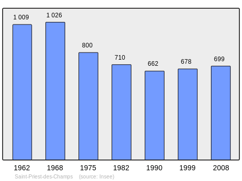
In 2010 the commune had 691 inhabitants. The evolution of the number of inhabitants is known from the population censuses conducted in the commune since 1793. From the 21st century, a census of communes with fewer than 10,000 inhabitants is held every five years, unlike larger communes that have a sample survey every year.[Note 1]
| 1793 | 1800 | 1806 | 1821 | 1831 | 1836 | 1841 | 1846 | 1851 |
|---|---|---|---|---|---|---|---|---|
| 1,983 | 1,873 | 1,946 | 1,892 | 1,981 | 2,159 | 2,202 | 2,259 | 2,253 |
| 1856 | 1861 | 1866 | 1872 | 1876 | 1881 | 1886 | 1891 | 1896 |
|---|---|---|---|---|---|---|---|---|
| 2,126 | 2,062 | 1,972 | 1,974 | 1,960 | 1,919 | 1,943 | 1,853 | 1,797 |
| 1901 | 1906 | 1911 | 1921 | 1926 | 1931 | 1936 | 1946 | 1954 |
|---|---|---|---|---|---|---|---|---|
| 1,760 | 1,814 | 1,766 | 1,527 | 1,382 | 1,335 | 1,254 | 1,165 | 1,024 |
| 1962 | 1968 | 1975 | 1982 | 1990 | 1999 | 2006 | 2010 | - |
|---|---|---|---|---|---|---|---|---|
| 1,009 | 1,026 | 800 | 710 | 662 | 678 | - | 691 | - |
Sources : Ldh/EHESS/Cassini until 1962, INSEE database from 1968 (population without double counting and municipal population from 2006)
Culture and heritage


- The Church of the Nativity of Saint John the Baptist
- The War Memorial
- Many Wayside Crosses
There is a Bourrée or dance called Bourrée de Saint-Priest (also known as Les garçons maçons). Many of these popular dance tunes, usually untitled and anonymous, have often been "renamed" in their collection, or interpretation, or the name of the collection place. There is a giate (a bourrée in triple time) in the repertoire of Jean Lecuyer, an accordion player at Saint-Priest-des-Champs.
Saint-Priest-des-Champs Picture Gallery
.JPG) The Church of the Nativity
The Church of the Nativity_%C3%A9glise%2C_chevet.JPG) The Chevet
The Chevet_%C3%A9glise_nef_central_avec_tribune.JPG)
_monument_aux_morts.JPG) The War Memorial
The War Memorial.JPG) A Wayside Cross in the Town Square
A Wayside Cross in the Town Square_croix_de_chemin_D62.JPG) A Wayside Cross on the D62
A Wayside Cross on the D62
Facilities
There is a convenience store and a postal agency in the commune. There is an osteopath near the church.
See also
External links
- Website on Saint-Priest-des-Champs (French)
- Saint-Priest-des-Champs on Lion1906
- Saint-Priest-des-Champs on Google Maps
- Saint-Priest-des-Champs on Géoportail, National Geographic Institute (IGN) website (French)
- St Prieft des Champs on the 1750 Cassini Map
- Saint-Priest-des-Champs on the INSEE website (French)
- INSEE (French)
Notes and references
Notes
- ↑ At the beginning of the 21st century, the methods of identification have been modified by Law No. 2002-276 of 27 February 2002, the so-called "law of local democracy" and in particular Title V "census operations" allows, after a transitional period running from 2004 to 2008, the annual publication of the legal population of the different French administrative districts. For communes with a population greater than 10,000 inhabitants, a sample survey is conducted annually, the entire territory of these communes is taken into account at the end of the period of five years. The first "legal population" after 1999 under this new law came into force on 1 January 2009 and was based on the census of 2006.
References
- ↑ Inhabitants of Puy-de-Dôme (French)
- 1 2 Google Maps
- 1 2 Géoportail, IGN (French)
- ↑ List of Mayors of France (French)
- ↑ National Commission for Decentralised cooperation (French)
| Wikimedia Commons has media related to Saint-Priest-des-Champs. |