Miravalles Volcano
"Miravalles" redirects here. For other uses, see Miravalles (disambiguation).
| Miravalles Volcano | |
|---|---|
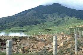 Miravalles Volcano in 1988 | |
| Highest point | |
| Elevation | 2,028 m (6,654 ft) [1] |
| Listing | List of volcanoes in Costa Rica |
| Coordinates | 10°44′54″N 85°09′10″W / 10.74833°N 85.15278°WCoordinates: 10°44′54″N 85°09′10″W / 10.74833°N 85.15278°W [1] |
| Geography | |
 Miravalles Volcano | |
| Parent range | Cordillera de Guanacaste |
| Geology | |
| Age of rock | 1.5 Myr |
| Mountain type | Stratovolcano |
| Last eruption | September 1946[1] |
The Miravalles Volcano is an andesitic stratovolcano in Costa Rica. The caldera was formed during several major explosive eruptions that produced voluminous dacitic-rhyolitic pyroclastic flows between about 1.5 and 0.6 million years ago. The only reported historical eruptive activity was a small steam explosion on the SW flank in 1946. High heat flow remains, and Miravalles is the site of the largest developed geothermal field in Costa Rica.[1]
The Miravalles Volcano reaches an elevation of 6,653 feet (2,023 m) and is the highest mountain in the Guanacaste Mountains. The heat from the volcano also helps power a geothermal energy plant at Las Hornillas, which is run by the Institute of Electricity.[2]
References
- 1 2 3 4 "Miravalles". Global Volcanism Program. Smithsonian Institution. Retrieved 2010-03-11.
- ↑ Stater, Adam. "The Miravalles Volcano".
| Guatemala |  | |
|---|---|---|
| El Salvador | ||
| Nicaragua | ||
| Costa Rica |
| |
| Panama | ||
Note: volcanoes are ordered from north-west to south-east. | ||
This article is issued from Wikipedia - version of the 7/5/2015. The text is available under the Creative Commons Attribution/Share Alike but additional terms may apply for the media files.