Milan, Indiana
| Milan, Indiana | |
|---|---|
| Town | |
| Town of Milan | |
|
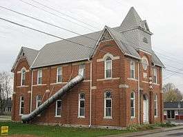
Milan's historic Masonic lodge building | |
 Location of Milan in the state of Indiana | |
| Coordinates: 39°7′22″N 85°7′50″W / 39.12278°N 85.13056°WCoordinates: 39°7′22″N 85°7′50″W / 39.12278°N 85.13056°W | |
| Country | United States |
| State | Indiana |
| County | Ripley |
| Townships | Franklin, Washington |
| Area[1] | |
| • Total | 1.98 sq mi (5.13 km2) |
| • Land | 1.95 sq mi (5.05 km2) |
| • Water | 0.03 sq mi (0.08 km2) |
| Elevation | 991 ft (302 m) |
| Population (2010)[2] | |
| • Total | 1,899 |
| • Estimate (2012[3]) | 1,878 |
| • Density | 973.8/sq mi (376.0/km2) |
| Time zone | Eastern (EST) (UTC-5) |
| • Summer (DST) | EDT (UTC-4) |
| ZIP code | 47031 |
| Area code | 812 & 930 |
| FIPS code | 18-49266[4] |
| GNIS feature ID | 0439132[5] |
| Website | http://www.milan-in-gov.net/ |
Milan /ˈmaɪlən/ is a town in Franklin and Washington townships, Ripley County, Indiana, United States. The population was 1,899 at the 2010 census.
Milan High School won the Indiana state basketball championship against Muncie Central High School in 1954, the victory being significant as Milan was the smallest town to win a state championship in the United States at that time. The 1986 film Hoosiers is based on the story of the 1954 Milan Team.[6]
While it is often claimed that Milan is the subject of a volume of poetry entitled "Pop. 359" written in 1941 by Carl Wilson under the pseudonym of Tramp Starr, that book is actually about the nearby town of Moores Hill.[7]
History
Milan was laid out in 1854 when the railroad was extended to that point.[8] The town, like its predecessor Old Milan, was named after Milan, in Italy.[9]
Milan Masonic Lodge No. 31 was listed on the National Register of Historic Places in 2013.[10]
Geography
Milan is located at 39°7′22″N 85°7′50″W / 39.12278°N 85.13056°W (39.122730, -85.130653).[11]
According to the 2010 census, Milan has a total area of 1.98 square miles (5.13 km2), of which 1.95 square miles (5.05 km2) (or 98.48%) is land and 0.03 square miles (0.08 km2) (or 1.52%) is water.[1]
Demographics
| Historical population | |||
|---|---|---|---|
| Census | Pop. | %± | |
| 1880 | 106 | — | |
| 1890 | 318 | 200.0% | |
| 1900 | 422 | 32.7% | |
| 1910 | 557 | 32.0% | |
| 1920 | 718 | 28.9% | |
| 1930 | 877 | 22.1% | |
| 1940 | 1,000 | 14.0% | |
| 1950 | 1,014 | 1.4% | |
| 1960 | 1,174 | 15.8% | |
| 1970 | 1,260 | 7.3% | |
| 1980 | 1,566 | 24.3% | |
| 1990 | 1,529 | −2.4% | |
| 2000 | 1,816 | 18.8% | |
| 2010 | 1,899 | 4.6% | |
| Est. 2015 | 1,886 | [12] | −0.7% |
2010 census
As of the census[2] of 2010, there were 1,899 people, 706 households, and 476 families residing in the town. The population density was 973.8 inhabitants per square mile (376.0/km2). There were 795 housing units at an average density of 407.7 per square mile (157.4/km2). The racial makeup of the town was 97.7% White, 0.3% African American, 0.2% Native American, 0.1% Asian, 0.3% from other races, and 1.4% from two or more races. Hispanic or Latino of any race were 0.8% of the population.
There were 706 households of which 38.7% had children under the age of 18 living with them, 44.2% were married couples living together, 16.9% had a female householder with no husband present, 6.4% had a male householder with no wife present, and 32.6% were non-families. 28.3% of all households were made up of individuals and 14.7% had someone living alone who was 65 years of age or older. The average household size was 2.53 and the average family size was 3.06.
The median age in the town was 36.7 years. 28.1% of residents were under the age of 18; 6.9% were between the ages of 18 and 24; 25.7% were from 25 to 44; 21.5% were from 45 to 64; and 17.9% were 65 years of age or older. The gender makeup of the town was 46.6% male and 53.4% female.
2000 census
As of the census[4] of 2000, there were 1,816 people, 693 households, and 460 families residing in the town. The population density was 955.2 people per square mile (369.0/km²). There were 768 housing units at an average density of 404.0 per square mile (156.1/km²). The racial makeup of the town was 98.51% White, 0.22% African American, 0.28% Native American, 0.33% Asian, and 0.66% from two or more races. Hispanic or Latino of any race were 0.50% of the population.
There were 693 households out of which 33.3% had children under the age of 18 living with them, 50.5% were married couples living together, 10.2% had a female householder with no husband present, and 33.6% were non-families. 28.7% of all households were made up of individuals and 16.5% had someone living alone who was 65 years of age or older. The average household size was 2.52 and the average family size was 3.13.
In the town the population was spread out with 27.1% under the age of 18, 8.9% from 18 to 24, 28.3% from 25 to 44, 18.8% from 45 to 64, and 17.0% who were 65 years of age or older. The median age was 34 years. For every 100 females there were 91.2 males. For every 100 females age 18 and over, there were 85.4 males.
The median income for a household in the town was $36,066, and the median income for a family was $41,435. Males had a median income of $31,512 versus $22,244 for females. The per capita income for the town was $16,191. About 7.9% of families and 9.0% of the population were below the poverty line, including 11.4% of those under age 18 and 9.0% of those age 65 or over.
Education
Milan Community School Corporation is organized of three schools - Milan Elementary, Milan Middle, and Milan High School. The corporation was a 2006 Indiana Department of Education Exemplary Progress School Corporation.
Notable people
- Gene White - Member of the 1954 Milan High School Indiana State Championship Basketball team.
- William Jordan - Actor (forty-five year career of more than 50 notable movie and TV show credits; most notably played Major Jake Gatlin in Project U.F.O.), and member of the 1954 Milan High School Indiana State Championship basketball team.
- Bobby Plump - Member of the 1954 Milan High School Indiana State Championship basketball team; "Mr. Basketball", 1954; Trester award winner, 1954; Most Valuable Player, Butler University, 1957, 1958; College Basketball All-Star Team, 1958; named one of the 50 greatest sports figures from Indiana in the 20th century, according to Sports Illustrated; Indiana Basketball Hall of Fame Inductee, 1981; author; restaurateur.
- Jamie Johnson - Member of the Grascals, the 2005 International Bluegrass Music Association (IBMA) Emerging Artist of the Year Award, as well as the Song of the Year award for "Me and John and Paul". In 2006 and 2007, they won the IBMA Entertainer of the Year award.
References
- 1 2 "G001 - Geographic Identifiers - 2010 Census Summary File 1". United States Census Bureau. Retrieved 2015-07-17.
- 1 2 "American FactFinder". United States Census Bureau. Retrieved 2012-12-11.
- ↑ "Population Estimates". United States Census Bureau. Retrieved 2013-06-25.
- 1 2 "American FactFinder". United States Census Bureau. Retrieved 2008-01-31.
- ↑ "US Board on Geographic Names". United States Geological Survey. 2007-10-25. Retrieved 2008-01-31.
- ↑ "'Hoosiers'-style celebration". The Herald Bulletin. Retrieved 2006-06-02.
- ↑ Starr, Tramp (1941). Pop. 359. Moore-Langen.
- ↑ Places, Indiana (18 November 2011). A Visit To Sunman and Milan, Indiana: A Travel Guide to Southern Indiana. Mossy Feet Books. p. 8. ISBN 978-1-4661-1079-3.
- ↑ "About Us". Town of Milan, IN. Retrieved 30 November 2015.
- ↑ "National Register of Historic Places Listings". Weekly List of Actions Taken on Properties: 1/07/13 through 1/11/13. National Park Service. 2013-01-18.
- ↑ "US Gazetteer files: 2010, 2000, and 1990". United States Census Bureau. 2011-02-12. Retrieved 2011-04-23.
- ↑ "Annual Estimates of the Resident Population for Incorporated Places: April 1, 2010 to July 1, 2015". Retrieved July 2, 2016.
- ↑ "Census of Population and Housing". Census.gov. Retrieved June 4, 2015.
External links
Municipalities and communities of Ripley County, Indiana, United States | ||
|---|---|---|
| City | ||
| Towns | ||
| Townships | ||
| Unincorporated communities |
| |
| Footnotes | ‡This populated place also has portions in an adjacent county or counties | |