Metaline Falls, Washington
| Metaline Falls | |
|---|---|
| Town | |
| Metaline Falls, Washington | |
 Location of Metaline Falls, Washington | |
| Coordinates: 48°51′41″N 117°22′15″W / 48.86139°N 117.37083°WCoordinates: 48°51′41″N 117°22′15″W / 48.86139°N 117.37083°W | |
| Country | United States |
| State | Washington |
| County | Pend Oreille |
| Area[1] | |
| • Total | 0.21 sq mi (0.54 km2) |
| • Land | 0.21 sq mi (0.54 km2) |
| • Water | 0 sq mi (0 km2) |
| Elevation | 2,090 ft (637 m) |
| Population (2010)[2] | |
| • Total | 238 |
| • Estimate (2015)[3] | 241 |
| • Density | 1,133.3/sq mi (437.6/km2) |
| Time zone | Pacific (PST) (UTC-8) |
| • Summer (DST) | PDT (UTC-7) |
| ZIP code | 99153 |
| Area code(s) | 509 |
| FIPS code | 53-45320 |
| GNIS feature ID | 1523023[4] |
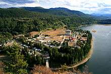
Metaline Falls is a town in Pend Oreille County, Washington, United States. The population was 238 at the 2010 census.[5]
History
Evidence of early indigenous peoples in the area dates to some 12,000 years ago. By 1810, European fur traders were crossing the area. The settlement of Metaline Falls was founded in 1900, with most of its residents then employed by the Mammoth and Morning lead-zinc mines.[6] Metaline Falls was officially incorporated on 13 May 1911.
The train sequences of the 1993 film Benny & Joon were filmed in the Metaline Falls area; the 1997 film The Postman was filmed in part in the area.
Geography
Metaline Falls is located at 48°51′41″N 117°22′15″W / 48.86139°N 117.37083°W (48.861462, -117.370867).[7]
According to the United States Census Bureau, the town has a total area of 0.21 square miles (0.54 km2), all of it land.[1]
Climate
Metaline Falls has a dry-summer Humid continental climate (Dsb) according to the Köppen climate classification system.
| Climate data for Metaline Falls | |||||||||||||
|---|---|---|---|---|---|---|---|---|---|---|---|---|---|
| Month | Jan | Feb | Mar | Apr | May | Jun | Jul | Aug | Sep | Oct | Nov | Dec | Year |
| Record high °F (°C) | 49 (9) |
57 (14) |
71 (22) |
87 (31) |
98 (37) |
98 (37) |
104 (40) |
108 (42) |
96 (36) |
87 (31) |
59 (15) |
55 (13) |
108 (42) |
| Average high °F (°C) | 29.9 (−1.2) |
37.3 (2.9) |
46.9 (8.3) |
58.9 (14.9) |
68.5 (20.3) |
74.4 (23.6) |
83.9 (28.8) |
82.3 (27.9) |
72.8 (22.7) |
57.2 (14) |
39.6 (4.2) |
32.4 (0.2) |
57 (14) |
| Average low °F (°C) | 16.6 (−8.6) |
19.5 (−6.9) |
25.2 (−3.8) |
31.5 (−0.3) |
39 (4) |
45 (7) |
48.6 (9.2) |
46.9 (8.3) |
41.3 (5.2) |
34.7 (1.5) |
26.9 (−2.8) |
21.7 (−5.7) |
33.1 (0.6) |
| Record low °F (°C) | −29 (−34) |
−28 (−33) |
−9 (−23) |
1 (−17) |
22 (−6) |
28 (−2) |
31 (−1) |
33 (1) |
20 (−7) |
−1 (−18) |
−6 (−21) |
−24 (−31) |
−29 (−34) |
| Average precipitation inches (cm) | 3 (8) |
2.27 (5.77) |
2.12 (5.38) |
1.8 (4.6) |
2.35 (5.97) |
2.71 (6.88) |
1.25 (3.18) |
1.07 (2.72) |
1.7 (4.3) |
2.65 (6.73) |
3.11 (7.9) |
3.35 (8.51) |
27.38 (69.55) |
| Average snowfall inches (cm) | 26.3 (66.8) |
15.7 (39.9) |
8.5 (21.6) |
0.7 (1.8) |
0.1 (0.3) |
0 (0) |
0 (0) |
0 (0) |
0 (0) |
1 (3) |
9.8 (24.9) |
23.1 (58.7) |
85.2 (216.4) |
| Average precipitation days | 14 | 12 | 12 | 10 | 11 | 12 | 6 | 6 | 7 | 11 | 13 | 15 | 129 |
| Source: [8] | |||||||||||||
National protected areas
Demographics
| Historical population | |||
|---|---|---|---|
| Census | Pop. | %± | |
| 1920 | 153 | — | |
| 1930 | 316 | 106.5% | |
| 1940 | 453 | 43.4% | |
| 1950 | 547 | 20.8% | |
| 1960 | 469 | −14.3% | |
| 1970 | 307 | −34.5% | |
| 1980 | 296 | −3.6% | |
| 1990 | 210 | −29.1% | |
| 2000 | 223 | 6.2% | |
| 2010 | 238 | 6.7% | |
| Est. 2015 | 241 | [9] | 1.3% |
| U.S. Decennial Census[10] 2015 Estimate[3] | |||
2010 census
As of the census[2] of 2010, there were 238 people, 124 households, and 54 families residing in the town. The population density was 1,133.3 inhabitants per square mile (437.6/km2). There were 206 housing units at an average density of 981.0 per square mile (378.8/km2). The racial makeup of the town was 94.5% White, 0.4% African American, 2.1% Native American, 0.8% Asian, and 2.1% from two or more races. Hispanic or Latino of any race were 1.7% of the population.
There were 124 households of which 24.2% had children under the age of 18 living with them, 36.3% were married couples living together, 4.0% had a female householder with no husband present, 3.2% had a male householder with no wife present, and 56.5% were non-families. 49.2% of all households were made up of individuals and 18.5% had someone living alone who was 65 years of age or older. The average household size was 1.92 and the average family size was 2.91.
The median age in the town was 48.3 years. 20.6% of residents were under the age of 18; 4.6% were between the ages of 18 and 24; 18.9% were from 25 to 44; 37.8% were from 45 to 64; and 18.1% were 65 years of age or older. The gender makeup of the town was 47.9% male and 52.1% female.
2000 census
As of the census of 2000, there were 223 people, 122 households, and 52 families residing in the town. The population density was 1,076.1 people per square mile (410.0/km²). There were 192 housing units at an average density of 926.5 per square mile (353.0/km²). The racial makeup of the town was 96.86% White, 1.35% Asian, 0.45% from other races, and 1.35% from two or more races. Hispanic or Latino of any race were 0.45% of the population.
There were 122 households out of which 18.0% had children under the age of 18 living with them, 36.1% were married couples living together, 4.9% had a female householder with no husband present, and 56.6% were non-families. 54.1% of all households were made up of individuals and 21.3% had someone living alone who was 65 years of age or older. The average household size was 1.83 and the average family size was 2.79.
In the town the population was spread out with 19.3% under the age of 18, 3.6% from 18 to 24, 21.1% from 25 to 44, 33.2% from 45 to 64, and 22.9% who were 65 years of age or older. The median age was 49 years. For every 100 females there were 95.6 males. For every 100 females age 18 and over, there were 85.6 males.
The median income for a household in the town was $17,083, and the median income for a family was $35,250. Males had a median income of $36,250 versus $18,333 for females. The per capita income for the town was $16,390. About 24.4% of families and 33.2% of the population were below the poverty line, including 48.1% of those under the age of eighteen and 16.2% of those sixty five or over.
References
- 1 2 "US Gazetteer files 2010". United States Census Bureau. Retrieved 19 December 2012.
- 1 2 "American FactFinder". United States Census Bureau. Retrieved 19 December 2012.
- 1 2 "Population Estimates". United States Census Bureau. Retrieved July 14, 2016.
- ↑ "US Board on Geographic Names". United States Geological Survey. 25 October 2007. Retrieved 2008-01-31.
- ↑ "2010 Census Redistricting Data (Public Law 94-171) Summary File". American FactFinder. United States Census Bureau. Retrieved 17 September 2012.
- ↑ Majors, Harry M. (1975). Exploring Washington. Van Winkle Publishing Co. p. 59. ISBN 978-0-918664-00-6.
- ↑ "US Gazetteer files: 2010, 2000, and 1990". United States Census Bureau. 12 February 2011. Retrieved 23 April 2011.
- ↑ "METALINE FALLS, WASHINGTON (455317)". Western Regional Climate Center. Retrieved November 18, 2015.
- ↑ "Annual Estimates of the Resident Population for Incorporated Places: April 1, 2010 to July 1, 2015". Retrieved July 2, 2016.
- ↑ United States Census Bureau. "Census of Population and Housing". Retrieved October 4, 2013.
Municipalities and communities of Pend Oreille County, Washington, United States | ||
|---|---|---|
| City | 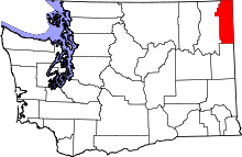 | |
| Towns | ||
| Unincorporated communities | ||