Mesquite, Borden County, Texas
This article is about the ghost town in Borden County, Mesquite, Texas. For the Dallas suburb, see Mesquite, Texas.
| Mesquite, Texas | |
|---|---|
| Ghost Town | |
|
Mesquite school (abandoned) | |
 Mesquite  Mesquite | |
| Coordinates: 32°52′13″N 101°37′49″W / 32.87028°N 101.63028°WCoordinates: 32°52′13″N 101°37′49″W / 32.87028°N 101.63028°W | |
| Country |
|
| State |
|
| County | Borden |
| Physiographic region | Llano Estacado |
| Founded | 1905 |
| Elevation[1] | 2,966 ft (904 m) |
| Time zone | Central (CST) (UTC-6) |
| • Summer (DST) | CDT (UTC-5) |
| Area code(s) | 806 |
| Website | Handbook of Texas |
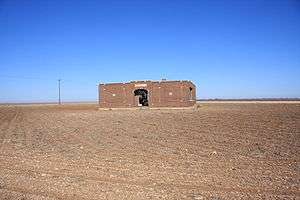
Mesquite is a ghost town in Borden County, Texas, United States. From its inception, Mesquite has remained a rural farming community. A school, established in 1905, served the area until sometime around 1930 when the building appears to have fallen into disuse. Today all that remains of Mesquite are a few residences, a Church of Christ, and the abandoned schoolhouse.[2]
Geography
Mesquite is located on Farm to Market 1054, east of US Route 87 and north of US Route 180. The nearest large community is Lamesa, about 15 miles (24 km) to the southwest.
See also
References
- ↑ "Mesquite". Geographic Names Information System. United States Geological Survey.
- ↑ Davis, Charles G. "Mesquite, TX (Borden County)". Handbook of Texas Online. Retrieved February 3, 2011.
External links
- Brief information on Mesquite
- U.S. Geological Survey Geographic Names Information System: Mesquite, Texas (Borden County)
- Photos of West Texas and Eastern New Mexico
Municipalities and communities of Borden County, Texas, United States | ||
|---|---|---|
| Census-designated place | 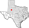 | |
| Other unincorporated community | ||
| Ghost town | ||
This article is issued from Wikipedia - version of the 11/10/2016. The text is available under the Creative Commons Attribution/Share Alike but additional terms may apply for the media files.